Clumner Bluff 2015 Sept

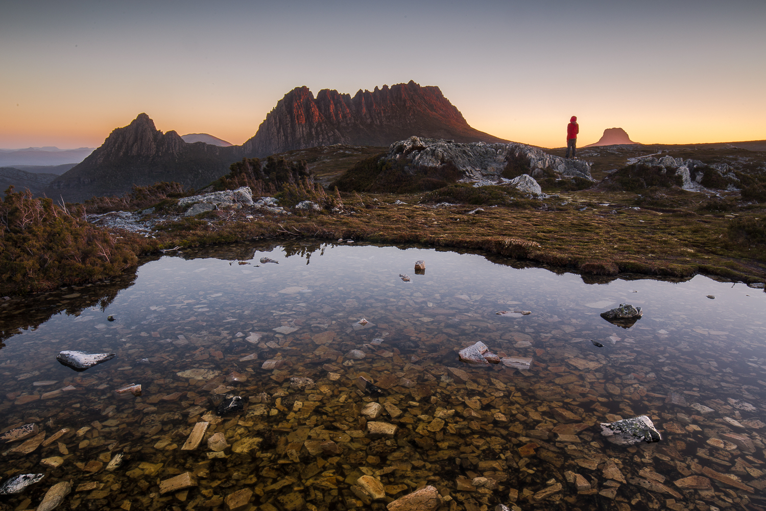
Not my photo. Neither is it my view (seeing’s I didn’t get one). This is a photo kindly sent to me by my friend David, taken from a snowy “summit B” under somewhat more ideal conditions than my own.

Clumnar Bluff. Hoorah. Sixth time lucky – if “luck” is what you call it. I have at last climbed you. Both summits. And what happened on the failed attempts? Is it a hard mountain? No, it is not hard at all, although I was starting to feel that it must be. So, what’s the story?
Time 1) It was frosty with icicles on the rock, so it was called off before we began, and we climbed a slippery, icy Mt Victoria instead. (It’s not as high).
Time 2) We got started, but didn’t even get half way. It was raining and cold, and our organiser was still recovering from an operation. We were obviously not going to make it, so we all opted for the comfort of the car and to the business of pulling leeches off ourselves while we drove back. The count was 42 leeches thrown out the window on the return trip.
Time 3) This trip was called off because of rain before we left our homes.
Time 4) I put my name on the list, but then discovered I had a clash and a trip organised up a more important mountain. That group made the top, but without me.
Trip 5) I was told we were skiing to Clumner Bluff. HOW exciting is that? I was thrilled. However, in the car on the way, I was told we were not going to Clumner at all.

This is also not my photo, but one offered to me by another friend, Catherine, showing me walking around a different lake on Wednesday. This is very similar to what we could have been seeing had we been able to see, or had the luxury of time to stop and take it.
Enough was enough. Obviously it seems, if you want a mountain dearly enough, you need to take matters into your own hands. I studied the weather and decided Friday was good enough for a try, despite the fact that either snow or rain was predicted for the afternoon (depending on the temperature). An early frost would at least mean that the snow would be firm for the way out. It would be several kilometres across the top once I’d climbed up to the snow, so I wanted to make sure of being out by midday, just in case it got slushy and slow, and in case sinking with every step became a possibility. It thus needed to be a trip with a nice early start, and one done on the march with very, very few stops, if any. Who would be up for such a trip? My friend Angela, of course. I was so annoyed with five failed attempts that I was prepared to go solo if she couldn’t come, but luckily for me, she could, so when the sky closed in and even the ground became difficult to see, I had the warmth of company.

Angela checking the summit. Sorry, it’s just a phone image. Beggars can’t be choosers. Having forgotten my camera, I had to learn to use my Galaxy, which won’t let me download onto my computer, so this got texted to my daughter and then emailed to me. Quality has been lost somewhere in all of that. Don’t be fooled by the shorts. It was COLD. Angela is tough!

Angela and I, as a duo, now have, by default, a very good – yea, pure – record of summitting success in the snow, and this mountain was no exception. I say “by default” as we don’t always set out intending to snow climb. It just happens to be the case. This time, however, the snow was sought out and courted. I thought it would be great fun to have my first summitting of this elusive mountain in winter white. The fact that it was also in a grey-out, done half-blind, just added spice.
At first the day seemed benign. I thought it would be another glorious one, like Wednesday. However, once we gained a contour or two and were exposed to winds coming from the west, we were hit with an icy blast, and quickly donned another layer to cope with the freeze. We were not deterred. It was chilling, but we also both had many more layers in our daypacks in case. To the west, the sky began to look dark and ominous. I checked my compass to note our bearing, as the land was almost featureless. The clouds were rolling in, and yet it was still so bright because of the snow that we both found our gps screens very hard to read; I was glad of the paper map and compass we were each also carrying. Somewhere in the clouds, Clumner Bluff was hiding, but it was a matter of belief, not of seeing – a belief based on the accuracy of map and compass, for the eyes told us nothing.

The wildness of the tops

The ground became exceptionally hard to discern. I changed from sunglasses to red-tinted ones, but I still couldn’t detect any helpful patterns in the snow that indicated where the ground was. Like a little old lady, I walked bending low to try to make out the ground. We crossed something we decided was a lake, treading very gently indeed as we crossed it. We had no idea how deep it was, or how stable the ice covering on top. I was so glad to have Angela’s company!!! On the return journey, we evaded that bit by doing a wide arc.
After maybe 50 minutes across the snow, a shadowy lump loomed up ahead. This must be Clumner Bluff. At last we come face to face. ‘Odyssea’ meets her giant. Up we climbed and exactly 60 minutes after cresting the snowy tops, we were standing on what we supposed was “summit B”. I assume this is the “historical summit”. However, even in the grey misty gloom, our eyes said there were higher things to our left (south). My old map told me nothing, as it lacked a black dot of any description for the summit, but Angela’s more modern map had a summit where our eyes said one should lie – apparently 10 meters higher than the one we were on. I really don’t know, and never will, if I would have had the courage to go even further into the dark mist and visually unknown without the company of a friend. I don’t need to know right now, as Angela agreed that we’d go on to touch the highest point, and not just this cairn and summit. It took us a further 15 minutes to reach it, but they were glorious minutes where we felt even wilder and freer than that first hour across the snowy plateau. Somehow or other this was the ultimate: wild and free on rugged eerie tops with wind so noisy we couldn’t hear each other speak; the only marks in the snow were wind waves and the tracks of wombats and wallabies. It was fabulous. And oh was it good to breast that summit rock and know we had at last got to the top of the runaway mount.

This was the clearest it got during a two hour period, which happened to coincide with when we were on the summit, and when we stopped for five minutes to celebrate before hastening away.

Here, after 2 hrs 15 mins walking from the car, we had our first break, if you call it that. I took four photos. Angela similar, and then we were away again. No food; no drink. We were still both in a hurry, as the weather really was quite nasty, and we both wanted to reach this nice thing called safety before we ate or drank or wasted any time. We had our first break from earnest progress, and I had my first drink and food of any description after 3 hrs 45 (12.15 pm), when we were successfully out of the snow, and about a quarter of the way back down the mountain. I had been right to think we needed to be out by midday. The snow had been a little sludgy towards the end. It started raining lightly as we tightened our seat belts to drive away, both feeling quite excited by the day’s adventure, and very, very satisfied with all that had happened.

Our walking route in blue. For instructions on how to get to the start, see the post before this one on XC skiing. We parked the 2WD just before the puddle, as suggested, 4.3 kms from the turn. At the puddle, you turn right, head up a steep section that 4WD cars with courageous drivers can do, until the tapes indicating the start. The additional walking resulting from parking that bit early meant we had to walk an extra 6 mins 45 to reach the carpark for the brave and well equipped.

For the first time in my very long life, I forgot to take my camera with me!!! It was in the car, but I thought it was in my pack. I realised 10 minutes into the walk that this was the case, but was not prepared to lose 20 mins getting it, given that I had calculated that we needed to be out by midday. As it was, our progress was so purposeful that I would possibly not have had time to use it apart from at the summit anyway. Wednesday was about photography; today was about business – if you call feeling the wondrous expanse of infinitude in nature’s wildness “business”.

16 kms; 500 ms climb = 21 km equivalents. 4 hrs 45 walking (plus lunch and four photos).

XC skiing Central Plateau Mersey Crag 2015 Sep

A day of XC-skiing, on which I tried to reach Mersey Crag, but failed as my shoes fell to bits after 2kms.

Unnamed lake (on my map, anyway) about 2kms from the start 

Turrana Bluff and Mersey Crag from one of our many vantage points

I am so in love with yesterday, and with the opportunities that living in Tasmania provide. While the rest of the normal world went to work, a group of us who are free on Wednesdays, either by default or design (unemployed, partially unemployed, deliberately semiretired or fully retired – some of them early to enable a better lifestyle) went off into the wilderness and had a glorious day skiing or walking in the snow.

Turrana and Mersey again

My gear had had a long rest in my attic. While I was a representative athlete, I was unwilling to ski in the winter, which was my European racing season, just in case I got injured, so the gear just sat. Yesterday I got it out and carted it to the top of the central plateau (about 400 ms vertical climb – not a big deal) and began skiing for the first time in a very, very long time. I felt a bit nervous, but just as I was getting the hang of it again, my shoe fell apart – literally fell to bits. I had to walk in a shoe and a (luckily, woollen) sock back to where we had mounted the plateau and exchanged ski gear for the walking gear I’d worn to get to that point. While the others skied off to the glorious blue and white yonder, I was “stuck” in the snow for a day.

Well, as you know, I adore photography, and had already been lamenting the fact that I was skiing past scenes that I had wanted to represent in my own creative medium. Now I could fill my heart’s desire and snap away at all that beauty. I also had a fantastic workout, as when I was finished snapping, I walked a nice long way, nearly as far as Mersey Crag, some of which was with a “new girl”, Catherine, whose borrowed gear didn’t suit her. She abandoned it and came walking with me. Being up there in those vast domains, surrounded by a world of blue and white was a refreshing, rejuvenating experience. I can’t wait to go back. With fewer setbacks (clearing the road of fallen timber, broken gear and more) I am sure we can get to the top of Mersey Crag and back in a day using that route.

Weather closing in a bit as we all head back to the start
Is this not heaven on earth?
To get to the start, drive past Lake Rowallan, taking the Dublin Rd to the left (as for Rinadena Falls or Turrana Bluff), and then take the second road to the right, Clumner Spur road 2. Follow it for 4.3 kms until the drivable end of the road where there are tapes leading up to the plateau using the Henry Shannon track, named after the conceiver and maker of this route to the top, who skied with us yesterday. If you only have a 2WD, you have maybe 700ms extra to walk, maybe less. I didn’t measure, but I am going up next time in my 2WD as my 4 is out of action at present, and I don’t see this as a great hardship. Just stop before the muddy puddle.

Collins Cap 2015 Aug

Russell Falls – not a bad alternative to playing in the snow.
With a good dumping of snow forecast for the weekend, it was hard to choose where to go to capitalise on this wonder. The best snow seemed to be for Mt Field, so we planned to go there. Luckily, I threw my Wellington Ranges map into the car, just in case. I say “luckily”, as we gave little forethought to the fact that we were going to the snow in a 2WD; that is not always a good idea. We don’t even own any chains that fit it. (Our 4WD was out of action this weekend).

Lady Barron Falls, looking very dramatic with so much water

I did actually get almost to the Lake Dobson Carpark, but there was a lot of snow, and I was nervous about hanging around. If conditions got one iota worse up there – which tends to happen in snow storms – then we were in a pickle. We retreated, admired (and photographed) two wonderful waterfalls, and then drove to Hobart, resorting to my plan B for the morrow, which was to climb Collins Cap.

I was rather excited to see that there was snow in the Myrtle Forest picnic area car park as we pulled in. This boded well. I looked forward to seeing the cascading creek with its banks decked in snow. It did not disappoint. I wondered about the creek crossings that lay ahead – how icy and slippery they might be – but left that as a problem for later.  As it turned out, they were manageable – just.

The second crossing – the easier of the two.

Just before the second crossing, we met a jolly trio of HWC members, whose footsteps in the snow we’d been following the whole time. Unfortunately they had turned around just after the creek, and were on their way back to the car. Somehow, in weather like that it’s nice to think of someone “up there” ahead of you; someone else wild enough to be on the mountain in snow with further storms forecast. Now the only footprints in the snow were those made by Paddymelons and wombats. I find it endearing that the animals of the forest choose to use the pathways created by humans for humans. They are smart enough to pick that these routes offer the least resistance to forwards movement. Once, after a snowstorm on Cradle, I was on the boardwalk following tiny footprints in the snow, and here I was doing it again. The path was not marked on the trees. I was deciding on its whereabouts by picking the clearest line through the vegetation – a method that became harder the higher we climbed, as vegetation thinned out.

There’s the best line. Straight through that puddle.

My husband got to follow my prints.

The beautiful rainforest, firstly characterised by ferns and later by small pandani plants with snowy caps on, eventually ceded to burnt out snow gums, especially once we’d crossed the fire trail. Climbing in some sections was very steep indeed. I guessed there were rocks under the snow, as otherwise I think we would have slipped downhill a bit. My foot found it easy to kick into or onto something horizontal despite the severe angle of the snow.

Clouds began encircling us; visibility lessened. Just as my husband’s “I think we should turn around” kind of noises increased, I gasped. Up ahead I could see that every single tree and bush had a glorious coating of ice. We were in fairy land. Sorry, but I was not turning around in the presence of beauty such as this. As long as it didn’t actually snow, I knew the way down would be much quicker than our ascent, not just because of not fighting gravity, but also because I was doing all the step kicking and all the route finding on the way up. As long as I could follow our own footsteps down, the task would be halved. On we marched.


Fagus adorned in white, sparkling jewellery.

Nearly there. B taking the lead so I could take a photo of his back as the ground levelled out for the summit.
As I suspected, the way down was almost lightning fast. Speeds in the snow on the way up had been extraordinarily slow, which is why the other group had turned back. You needed to be prepared to take twice the normal time to factor in for step kicking, general caution and deciding where the track might be once things got vague. I had fun in the snow. I would have liked to use my macro lens on some of the formations, but moving was a high priority in those conditions.

Projection Bluff 2015 Jun

From the base of Projection Bluff as we passed it the first time

Luckily Projection Bluff is not far away from our intended mountain for the day, which had been Rats Castle, for we piked out of the latter. The story goes like this:
We stood at the base of Rats Castle, feet crunching the icy snow, wind howling ominously around our ears, numb, aching hands held close to our bodies in a vain attempt to warm them – and we hadn’t yet begun clutching icy vegetation. Our overpants seemed ineffective at offering any kind of help in protecting us against this blast. I gazed up to where our goal lay, up there beyond the couple-of-kilometre-long band of frosted scrub, and up above the blocks of now white dolerite. Dark clouds were swirling on the tops. It would be slow work along the ridgeline, making sure we didn’t slip on the thin ice carapace that covered each rock. Snow started falling again as we considered. This worsened matters.

The walk begins …

“If this snow continues, it may make the road undriveable on the way out,” I mused aloud. I was beginning to feel decidedly wussy about this whole venture. Luckily for me, Angela agreed to a change in plans. Let’s do nearby Projection Bluff instead – short, sweet, a pad with markers hopefully so that we didn’t have to bush bash and could move quickly enough to maybe even warm up. The path would debouch us onto the rocky area much more quickly than the alternative in front of us, and if the rocks  were treacherous, well, we’d turn around. The trouble with our planned Rats Castle was that we could work for a few hours and only then discover the rocks wouldn’t admit passage under these conditions. By choosing the shorter Projection Bluff, we’d at least get a mountain in for our drive.

So, here we were at the startling line a second time, ready to push through snowy bushes, wondering where the “pad” was, buried somewhere there under arching bushes and covered in white. We had trouble locating it at first, and decided it wasn’t there, but then some markers appeared, then disappeared in a frozen lake, but eventually reemerged in icy rainforest once we happened on the right spot out the other side. After that, it was plain sailing – just the normal game of “spot the marker” as we climbed, being careful not to be caught out on slippery ice.

 The exercise even warmed us up enough for me to shed my ridiculous oversized goretex mittens that made me shockingly clumsy and that fell off every few metres. I had enough feeling in my fingers to plait my hair at last so I could begin to see. I even had enough movement in my fingers now to tie my shoelaces properly for the first time that day.

The views from the moment we popped out above the tree line were worth any discomfort we may have felt earlier on. I was in love. Click, click. Two or three metres’ progress. Click, click. Poor Angela. She waited with great patience as my photography slowed us down far more than the icy rocks. What a privilege it was to climb something, even as small as Projection Bluff, in conditions such as these, and to witness such enormous stretches of beauty laid out before us.


Hobhouse 2015 Jun

Mt Hobhouse success.

The forest just below the rocks of the ridge. Our first stop where we took off the packs (for a quick drink) – which meant I could have an equally quick snap with the camera that was tucked out of the weather in cosier environs.
“Mt Hobhouse. That’ll be a tough one to get on a short winter’s day,” an acquaintance said, and of course, he was right, but we just wanted to do it, so that was that. Did one always need to be sensible?
I was farewelled on my way by the Launceston debating community, as we had had Parliamentary Shield on the Saturday. To many of those people, who inhabit a very different world to mine, the notion of abandoning creature comforts to drive over an icy and dangerous Central Plateau to then attempt to climb a remote mountain in semi-snow was something almost outrageous. They wished me well with all their wonderful hearts. My students had won both trophies on offer. The memory of their warm hugs and delighted faces, and the joy shown by their families, lining up to photograph them with their booty, buoyed me as I drove. I don’t often travel to the mountains in a skirt and stockings. I hoped Angela would recognise me in this uncharacteristic and utterly unsuitable attire. She laughed when she saw me and suggested I carry the stuff up to wear on the summit for our victory photo. I declined. We were going to stay at Bronte Park Village which has an open fire. I’d dress more appropriately later. Let’s brave the ice on the road now, without delay, before it got any worse.

Moody forest and cliffs near the top.

…
And here we were, sniffing the top. It had to be that next lumpy shadow appearing out of the mist. I’d checked off all the features as they went by; this was finally it.
“I can hear in your voice you’re getting excited now,” Angela commented, with enough momentum to carry her to the top even if her legs dropped off her torso right at this moment.
“Yep,” I agreed, unwilling to call it success until this moment, but now, now, it would take an atomic bomb or a fatal heart attack to keep us from that prized summit stick. We crunched on the last of the snow and covered the final twenty metres of our day’s directed endeavours.
The mountain had seemed so formidable on our first attempt – because we had come up onto the ridgeline a tad too early and had met a solid wall of cliff, well fortified by a palisade of dauntingly thick scrub. Now it seemed nothing but a song and dance across the ridgeline to the top. Amazing what 100 ms difference can make.

Weeee. We’ve done it. Angela on top.

This trip was not about views. It was about undoing a bad job last time and not admitting defeat. Last time we had done all the hard work of getting up onto the same ridgeline we were now on, but we had been timed out of finding a way around the cliffs so we could reach a point from which ascent was possible. We had started too late, underestimated our mountain, and were not prepared enough in our homework (we had actually not intended to climb the mountain on that day. It was a last minute switch).

Fabulous summit views.

So dedicated were we to our task this time that the only breaks were a toilet stop, a quick drink before the ridgeline, and a bit of time wasted looking for a cairn that we have decided has been knocked down by fallen timber (of which there is a lot. Recent storms have caused quite a number of new obstacles, even since last time we were there). We were at the top by midday, having survived the overgrown and very unclear bombardier track, the magnificent and quite open rainforest of the early part of our ridge, the slow and snowy bauera and eucalyptus band between it and the ridgeline, and the final, enjoyable semi-romp of the last section where the bushes were lower and a pad could even be seen.

Picturesque lunch spot on the descent that offered rocky substratum for our packs and shelter of sorts in the rain.

The weather was such that we didn’t linger long on the summit, and chose to eat our rather hasty lunch in the rain at the bottom of the cliffs prior to plummeting down into the bauera once more. I timed it to this spot. Twenty-three minutes. It was where we had passed through on our retreat last time. How sad that we had been so close the summit, yet had not had the time to go there. Of course, at the time we didn’t realise the journey would be so quick, and our decision to turn around had been a wise one given the time. We did not have forty six minutes (plus photos) to spare on that day, and we thought it would all take a lot longer than that, containing the possibility, we thought, for many errors and false chutes. This time we knew better, thanks to the kind advice offered to us by both Phil Dawson and Becca Lunnon, who each described their (basically identical) route across the ridge. That knowledge gave us more confidence this time.

This time I am posting both a 1:100,000 map (here) as well as the more normal 1:25,000, as this one has darker contour lines that make the shape of the land and our route more obvious. The other scale on this particular map has oddly light contour lines, and as, for me, a map is all about contours, I find that excessively unhelpful. I’ve done all I can to darken them.

The trip back, retracing our steps was uneventful if you don’t count the fact that our clothes were so sodden they were hard to keep on, and that we increasingly resembled odd wooden puppets trying to move in a way that kept pants up and frozen feet operating. We were both a little worried about how very numb our fingers were, knowing that we would need them for our lives right at the very end, but, here I am, alive to tell the tale. The return trip was slower than the ascent – partly due to the fact that the bushes now bent low over the bombardier “track”, making it impossible to differentiate from its ambient non-track scrub. We lost it several times, but were still out with a nice amount of light to spare so we could see the ice and snow on the road and attempt to dodge the animals that decided suicide at Angela’s hands was the way to go.

Here is the 1:25,000 version which usually gives you more information, but with the contour lines so very washed out, is not as useful as it should be. A combination of the two should give you all the information you need to determine our route, I hope. The line crossing the ridge is a boundary line. Don’t be tricked into thinking it’s a helpful track, although at the very top, just for the end game, there is a bit of a pad in the shorter vegetation.