Rawlinson Falls 2018 Mar

Rawlinson Falls. Mar 2018


Rawlinson Falls
I was very curious to see what happened to the contoured track after Montezuma Falls as it wended its way west towards, inter alia, Rawlinson Falls. The (beautiful) path is now part of an eighteen-kilometre MTB track, which is a great initiative. This track is also open to 4WDs and quad bikes, with all their noise and petrol fumes. I was pretty worried about being splattered with mud most of the time; however, no one got me. That said, I always felt the onus was on ME to get out of their road, and that they wouldn’t slow down much to give me an opportunity of finding a good spot to get off their turf. I saw four quads and about eight or more 4WDs on my journey. The sound carries, so it seemed like more. I must admit, on the positive side, that all bar one of them thanked me for moving out of their road. I like courtesy.


It took thirty eight minutes from Montezuma to Rawlinson (I wasn’t mucking around), and then the fun began. I thought these ones would be a breeze – hey, they’re just beside the track. No breeze was blowing that day! I followed the creek the short distance from the bridge and … whoah, that’s a huge drop!! How am I to get down there? I knew it was humanly possible, so I opted to go back quite a bit, and angle in (not clear from the map below) to cut the gradient. Do not try this if you are not experienced. It really was very steep. I was travelling solo, and no one knew where I was, so I was a little anxious. For every single step I took, I made sure one arm was around a nice healthy young tree that would not break. I trusted nothing dodgy. Not only can you harm yourself greatly if you don’t know how to handle slopes like this, but you could also cause a landslide that would harm the environment for everyone else. If you photograph from the top, you have still bagged the falls.

I was rewarded for my efforts by the sights in these shots. I took one (not here) from half way down, perched above a sapling, as I never actually believed I’d get to the bottom, so was feeling quite jubilant to reach flat land below. Having not slid at any time, I knew I could easily get up my downward route.

Montezuma Falls 2018 Mar

Montezuma Falls Mar 2018.


Water tumbles quietly over the base of the falls
I feel rather ashamed to write that last weekend was only the second time I have ever visited the renowned Montezuma Falls. This is especially shameful if one considers how very beautiful the area in which they are situated is. And it is perhaps even more so if I add that I only actually visited them as I was on my way to other, more distant waterfalls; they just happened to be the first ones I came to directly on the track.

On  my first visit, they were pumping so wildly it was impossible to keep the spray off one’s lens, and I threw my picture out. This time, the problem was kind of the opposite, in that they were flowing so demurely that I could sit on top of them and not really get wet. As a result, the photos included here are more “details” of the lower outlet of the falls. You could certainly get up close and cuddly this weekend. Meanwhile, however, if you’re not obsessed with seeing massive and unphotogenic gushes of water down your falls, the delicacy of the offering was, for me, quite appealing, and I absolutely adored the lush green forest en route.

And why on earth did I visit these falls on a hot day in March when the water was bound to be undramatic and the forests bereft of fungi and mist? Because, essentially, this trip was a recce to check out Rawlinson, Frazer and Svengali Falls. I would be driving down from Launceston, and then covering about 22 kms over rough ground on foot, some of which would be bushbashing. I wanted to be able to move quickly (not too much mud) and to walk in river beds should I need to, just to suss things out and get a rough time-frame for the expedition. I now know, for example, that it takes about 55 mins to reach Montezuma, another 38 to reach Rawlinson, and 30 mins to climb up to Frazer. Such items of knowledge are handy when planning future trips. I also learned that bringing just one ETC salad roll and florentine plus OJ is not enough to keep me in food for such an expedition. As usual, I was hungry most of the day, and was stealing lunch by 10 a.m.. I got very low on blood sugar by the end.


Loved the cows early on in my trip to the falls, shortly after leaving Launceston.
For reports on the other falls, see www.natureloverswalks.com/rawlinson-falls/ and www.natureloverswalks.com/frazer-falls/. I was too tired and hungry to do any more than a brief exploratory journey in the direction of Svengali. They’re for another time.


The tiny “settlement” in the top right corner is Williamstown, where you park. The road to it begins 2kms south of Rosebery, and is 6kms long. The Falls are marked on the sign that says Williamstown.

Cuckoo Falls 2018 Feb

Cuckoo Falls Feb 2018


Bruce and I tried to get to Cuckoo Falls two years ago, but made the mistake of underestimating how much time it would take. We didn’t get started until 3.30 on a winter’s afternoon, and never reached our goal. On that occasion, we spent a lot of time putting out tapes in the forest, pulling in tapes that went  in an entirely misleading direction, and breaking bracken fronds along the old track so that the way would be clearer, and the going faster next time. At last, this weekend that ‘next time’ came by, but Carrie was a to be my companion this attempt.


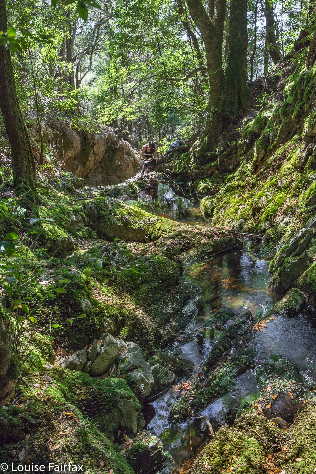
Now, please don’t get excited when I tell you I put out tapes. My old tapes were still there, indeed, and they had had babies, which is great, as other tapes had joined them, but this does NOT mean that the going is easy or the way is clear.  Like last time, I had a little bag of ribbons of varying colours, grabbed from here and there, and we added even more tape when we thought things weren’t clear, but the trick to adding tape is that you do NOT add it unless you know for sure you’re on the right track, for otherwise you are more of a hindrance than a help. This means that when you need the tape most, you can’t put it out, as you are not confident you’re on track. Once you become sure again, of course, you don’t need tape. Carrie put up with my going backwards on several occasions once we knew we were back on track, and I put tapes where I hoped it would be helpful.


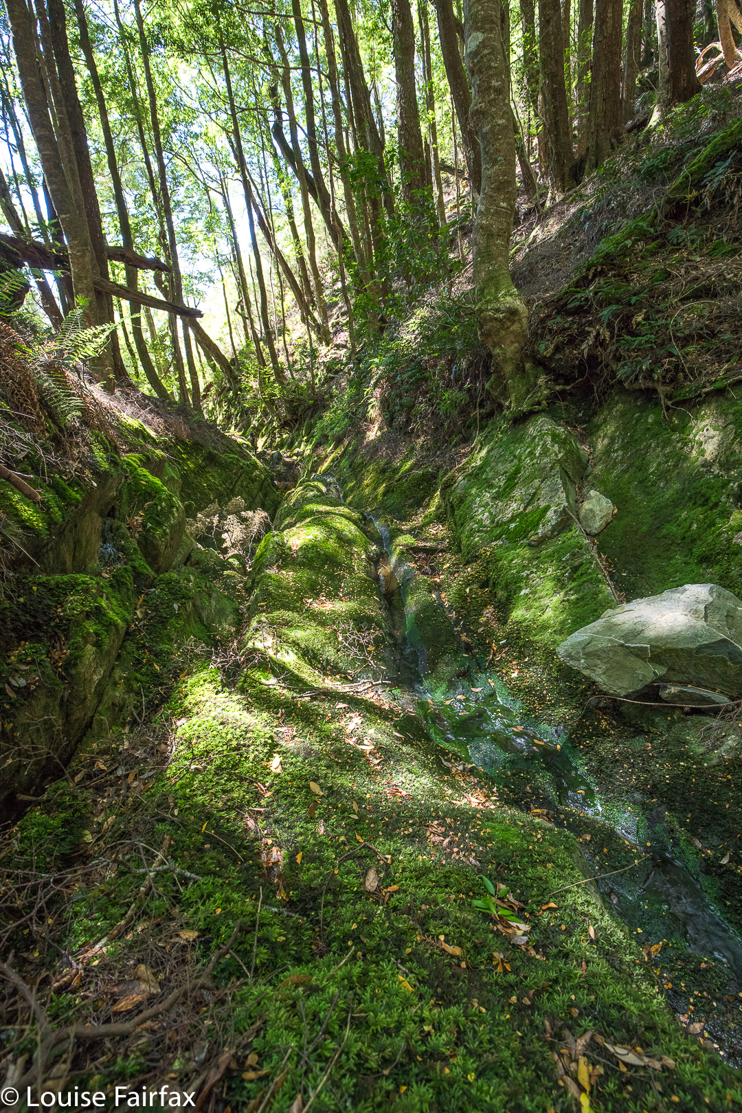
But again, please don’t rejoice and think I have now solved all your problems. Even with the path thus “fixed”, I had to use my gps several times both on the outward and return trips to ensure we hadn’t wandered. There remains ample room for error, and this waterfall must absolutely not be attempted unless you really know what you’re doing. Not only is the path unclear on many occasions, but the way, especially at the end, is rough, violently steep, and challenging, and the rainforest you traverse is old and decayed. Both of us fell now and then when the forest floor gave way under us. This can prove fatal, as Philosopher Smith noted when he was exploring old rainforest further west. I also think that Bruce must have had a fall in the forest (having wandered off track) and got covered by leaf litter: it’s my only explanation as to why we never found him, despite a huge, professional search. Walking in old, decayed rainforest is not to be done without full knowledge of the dangers. I once watched a very experienced bushman break his tibia when a log gave way underneath him, upsetting his balance. I once did a dangerous faceplant down a slope for the same reason. You’re not expecting what’s under you to give way, and so you tumble when it does.


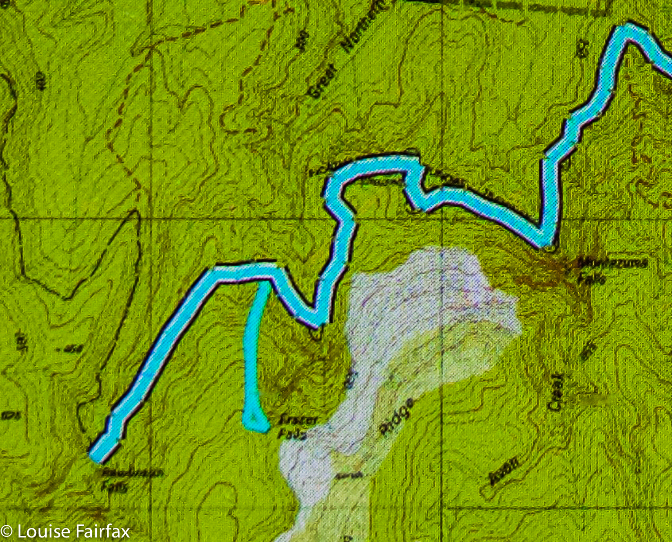
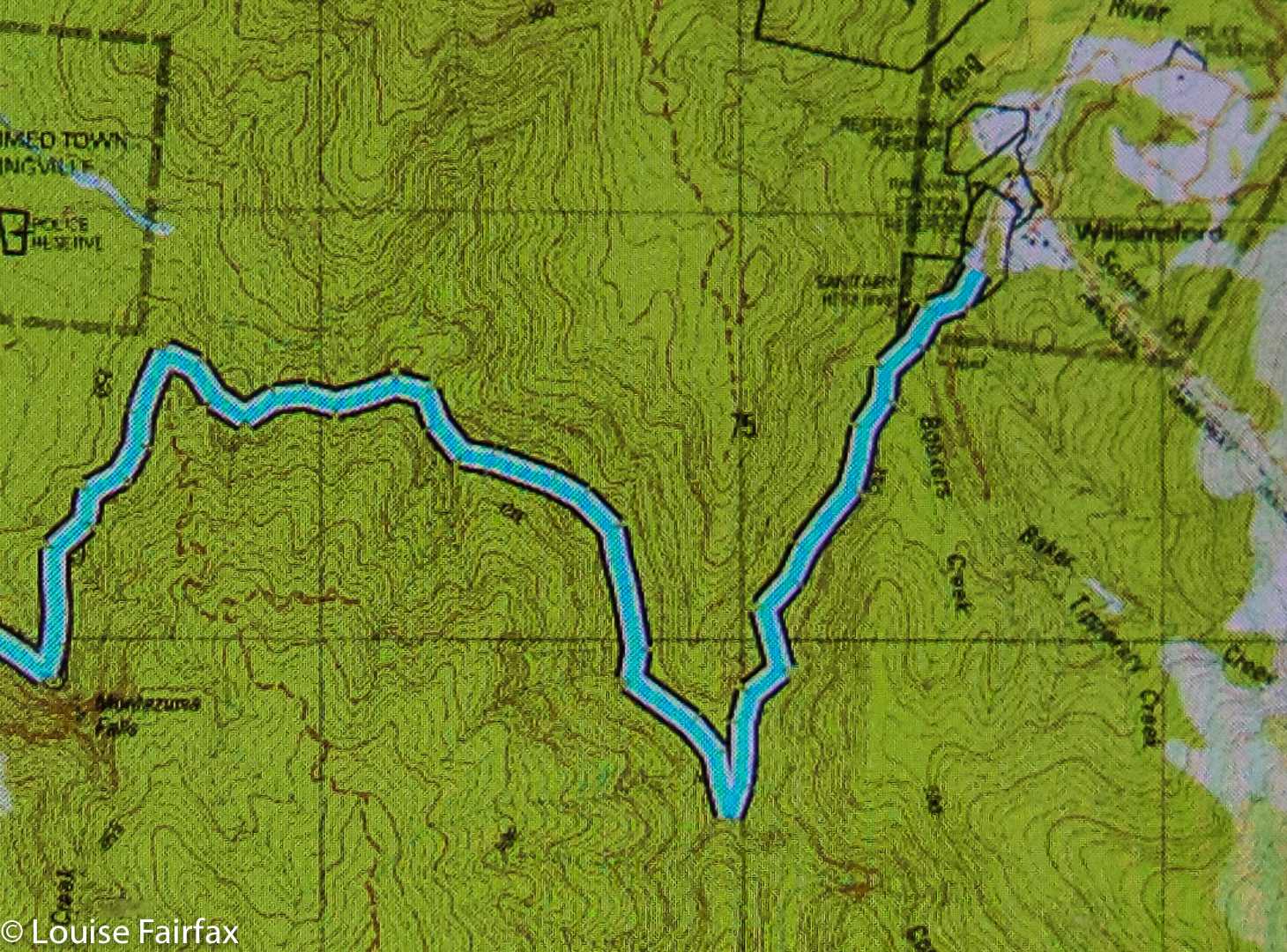
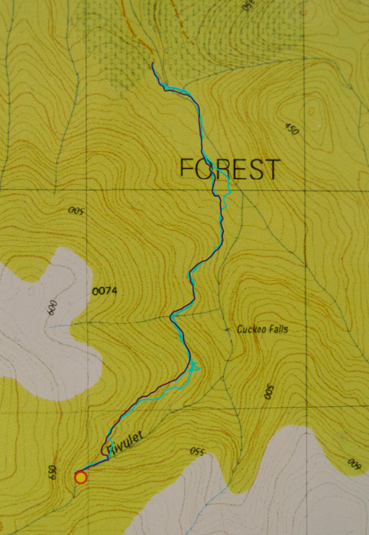
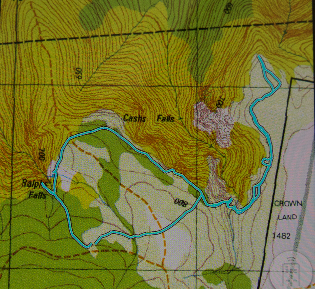
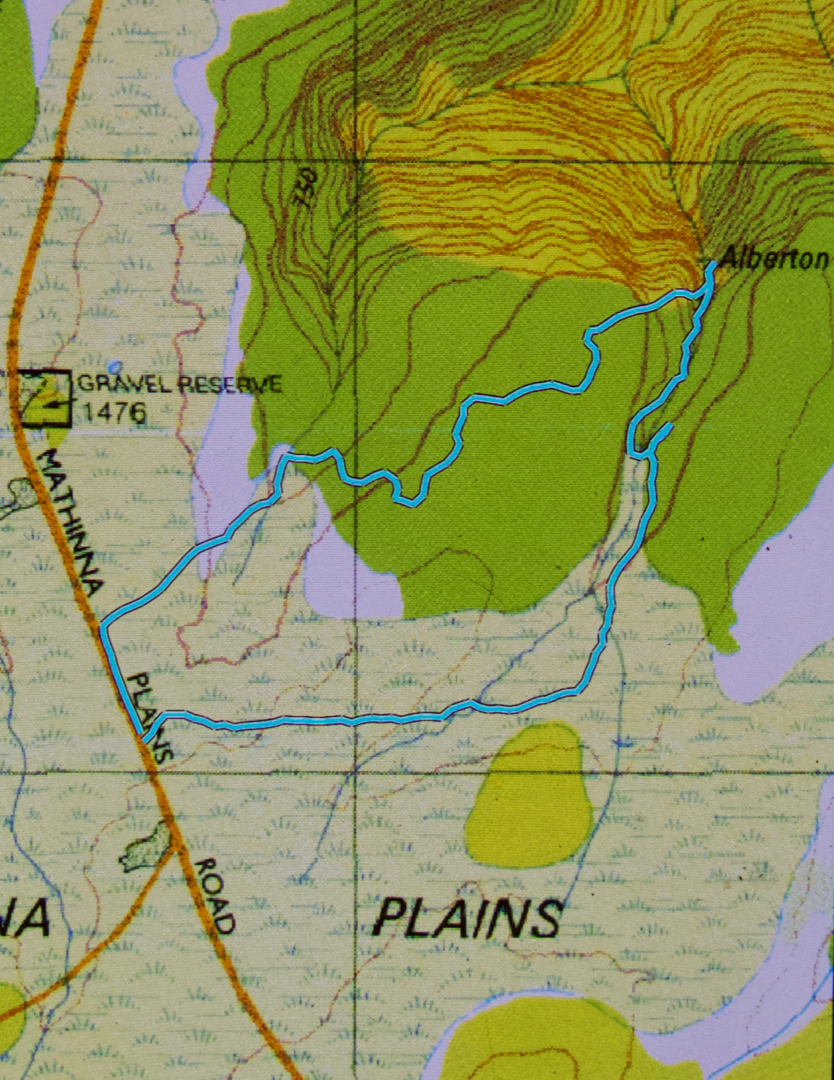
I am putting in my map of our route below to show you its shape. This is nothing new, but merely a shortcut for you, as the shape / route can also be seen on the List Maps, or on old 1:100,000 maps. What is clear on a map is not so arresting on the ground. This is not a track for “tourists” or people who “just” like photography, or even for “track-type” bushwalkers. It’s for experienced, off-track bushwalkers, wearing boots and gaiters, who not only know how to read maps, but also know how to move through potentially dangerous areas, and how to manage steep slopes, as there is an art to negotiating unstable areas and not causing a landslide that would damage the person or the environment. If you are an experienced walker, then this area is pure magic.


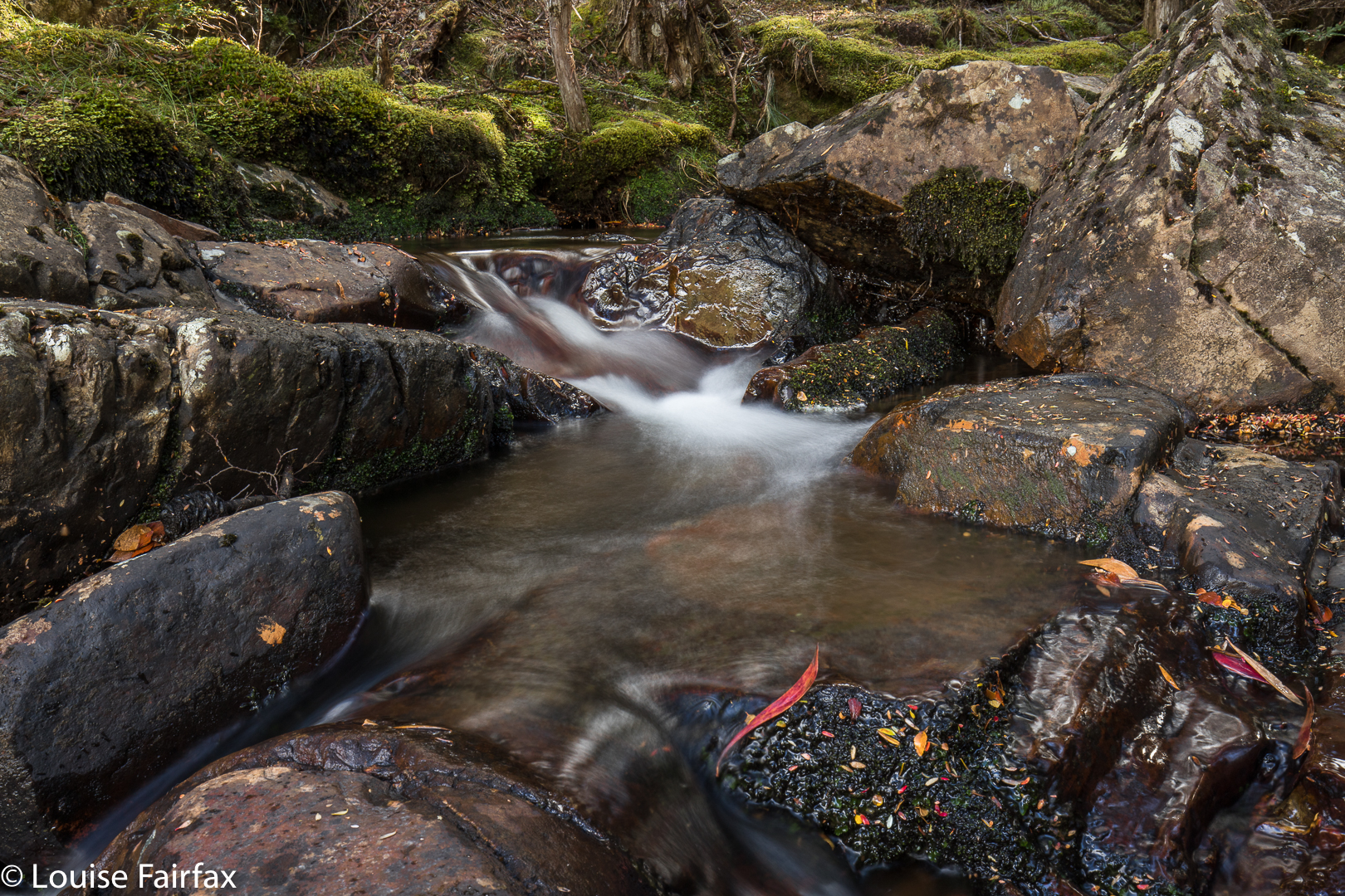
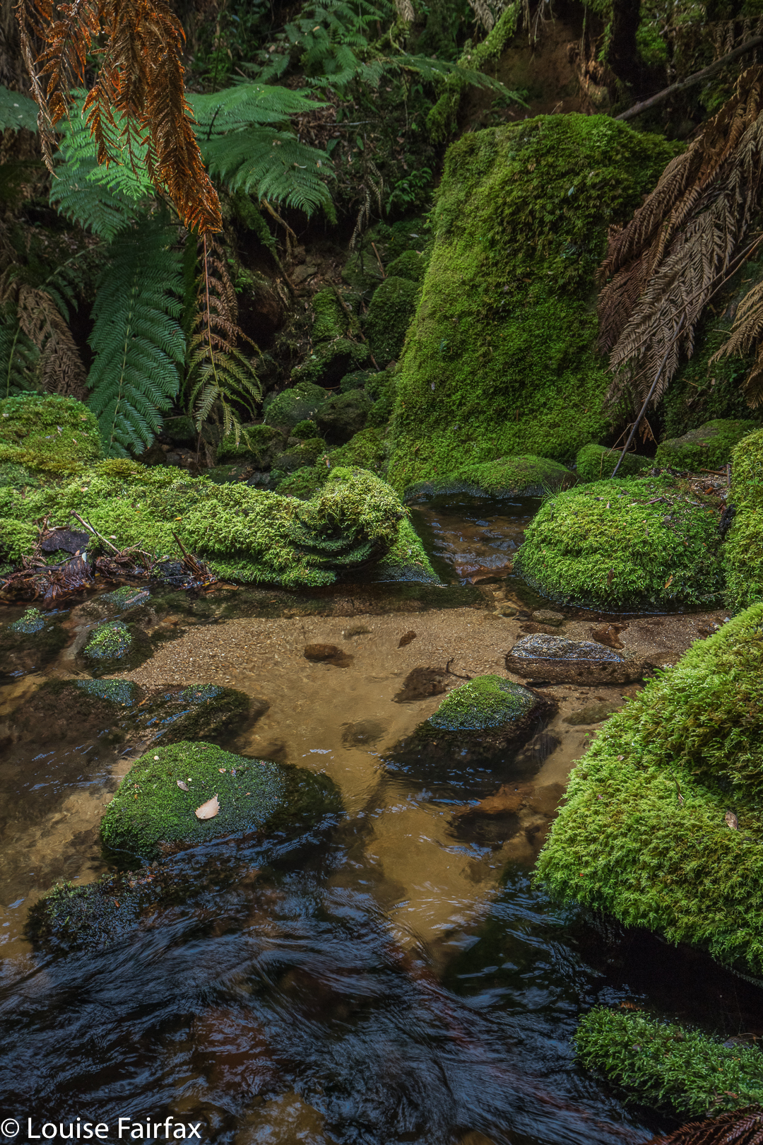
So, enough dire warnings. Let the story begin. As hinted above, it begins by negotiating a very unclear path through delightful ferns, alongside a magnificent creek that is soon left behind as you ascend to dryer domains where the undergrowth is not so lush, but the forest is still pleasing. That said, it comes as a relief when you at last once more hear the sound of running water, as, by this time, you are getting impatient for your goal. We took one hour forty to cover the mere three kilometres of the outward journey, and I would not call us slow. One has to be hesitant in such country, or else it is easy to wander off the route. Like a tracker, you are on the alert the whole time for signs that other humans have been this way.

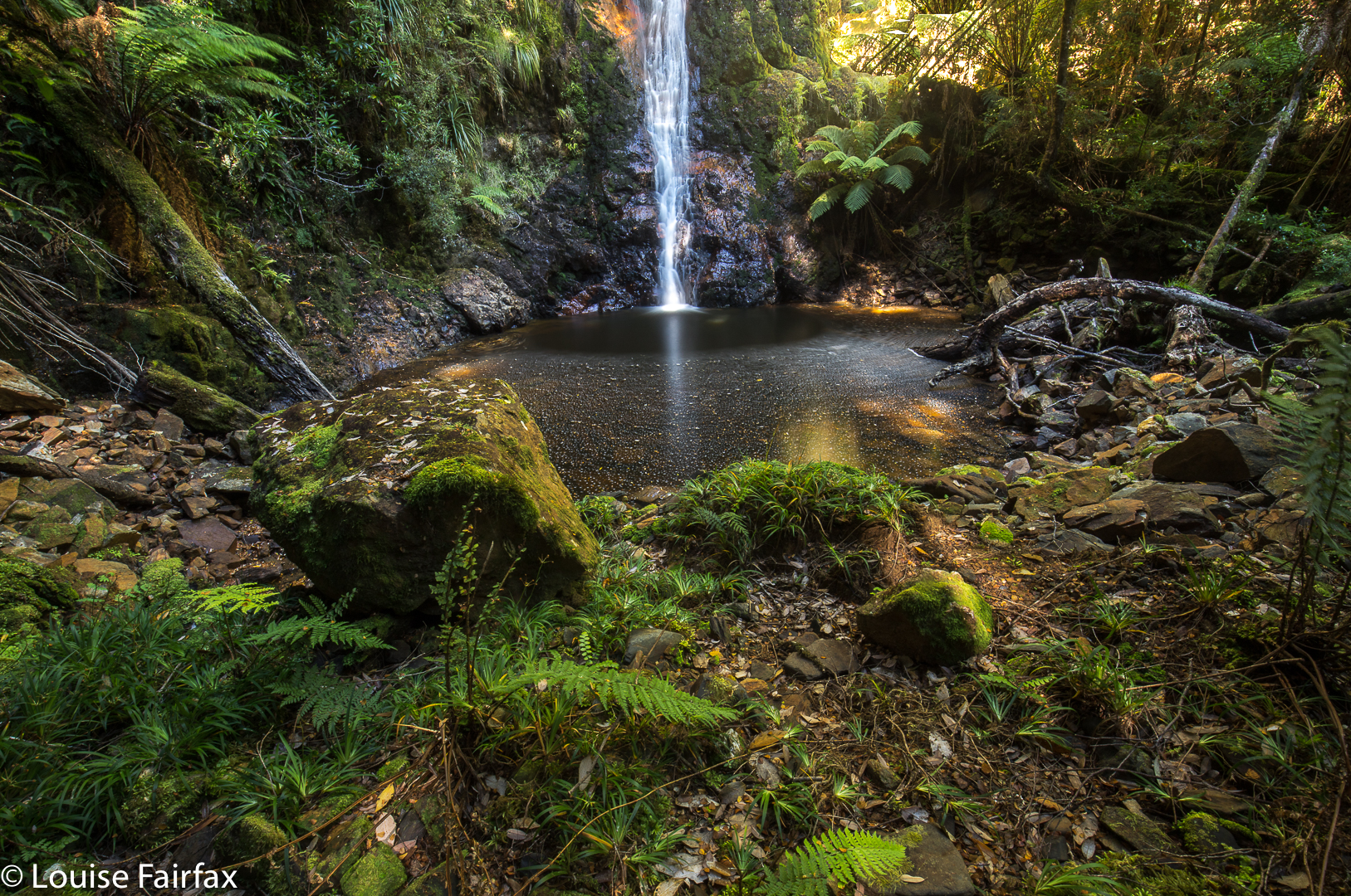
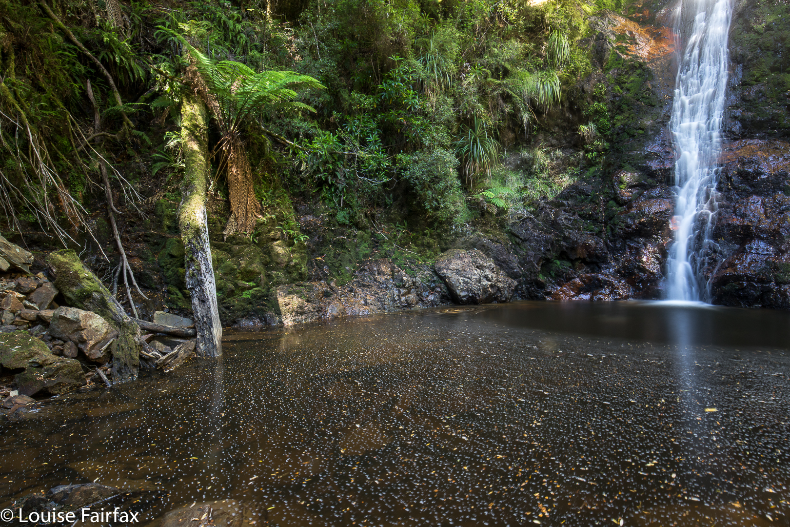
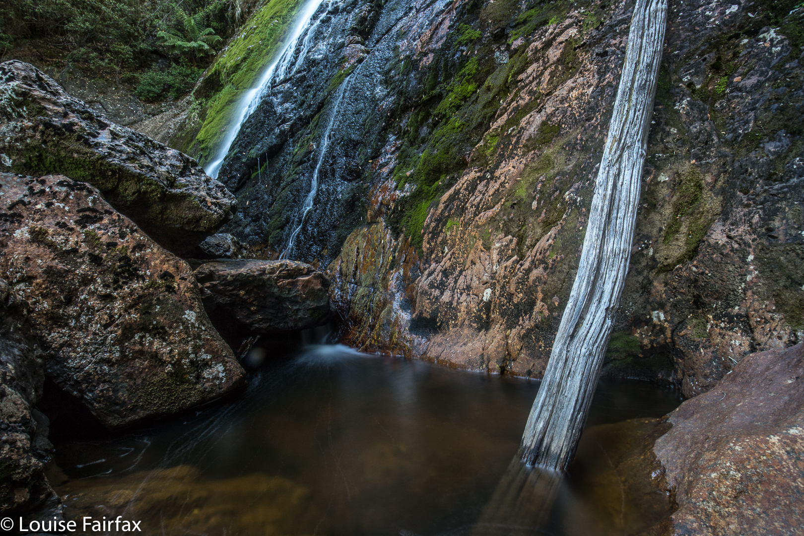
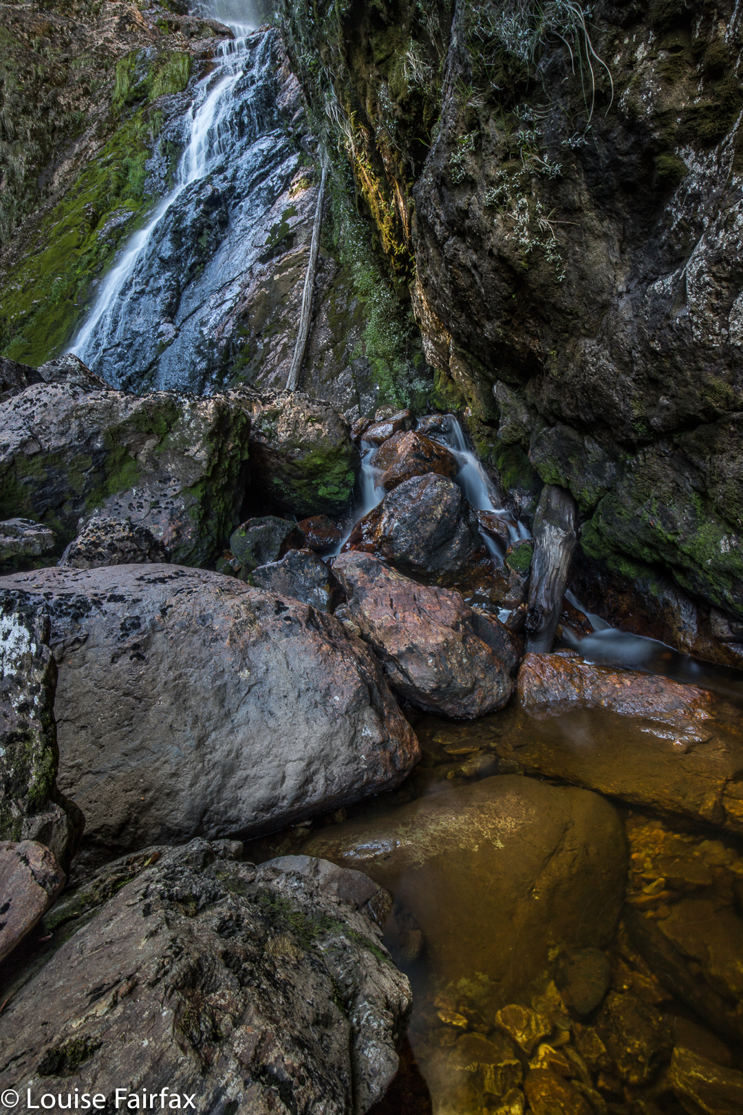
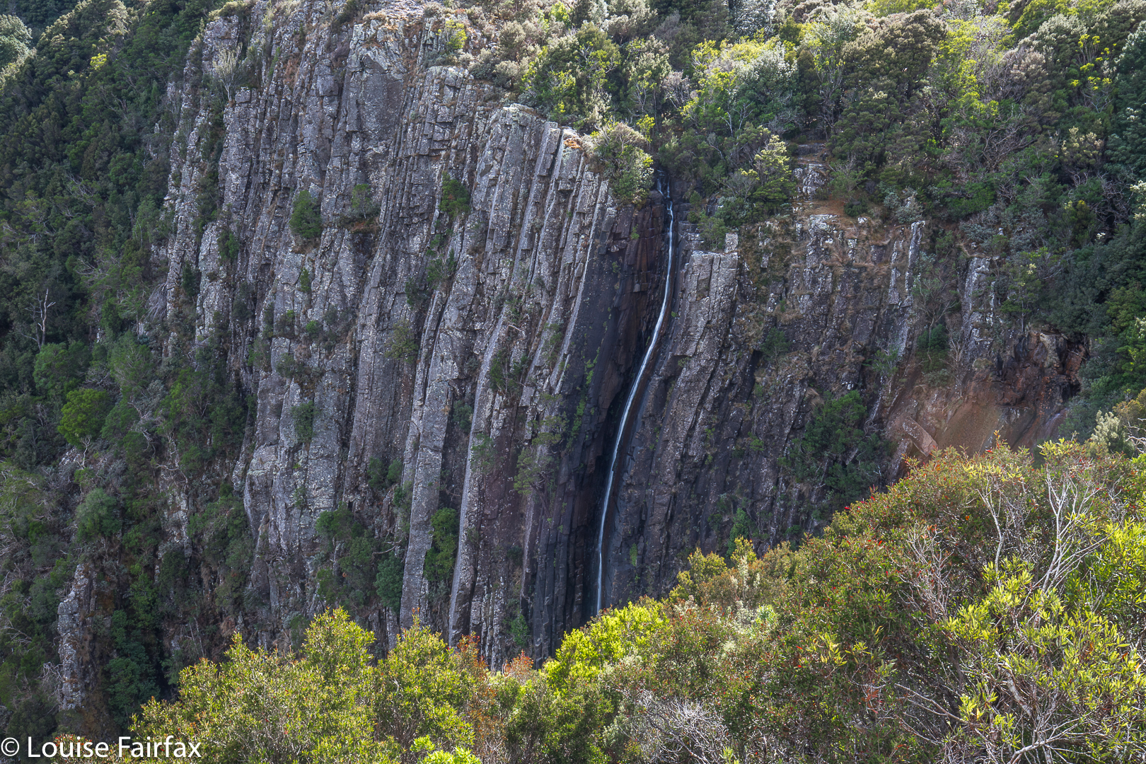
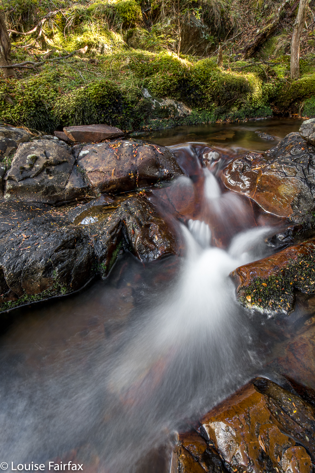
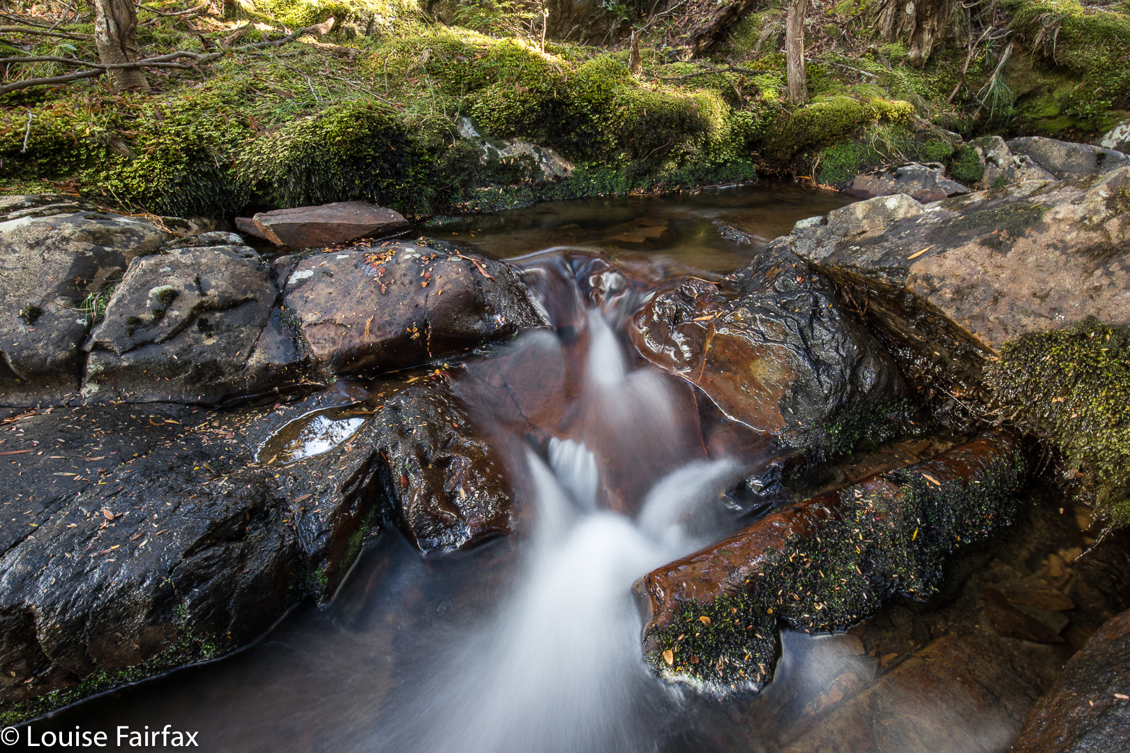
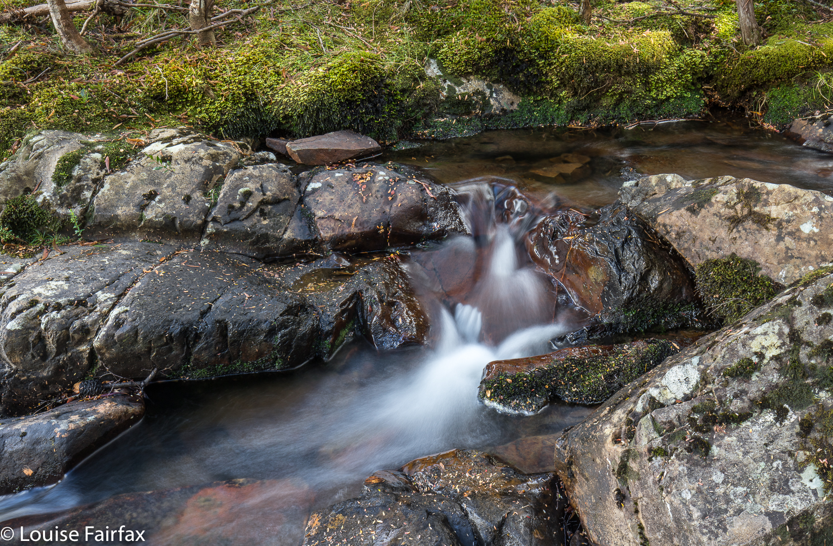
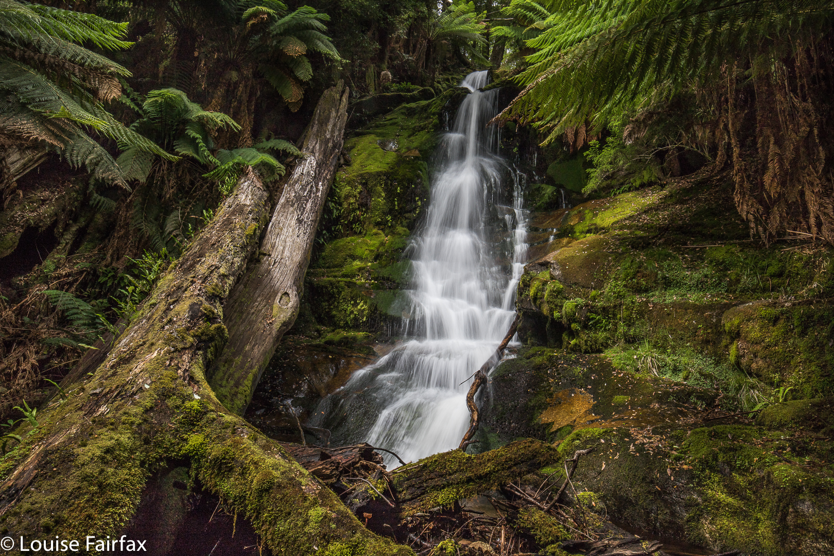
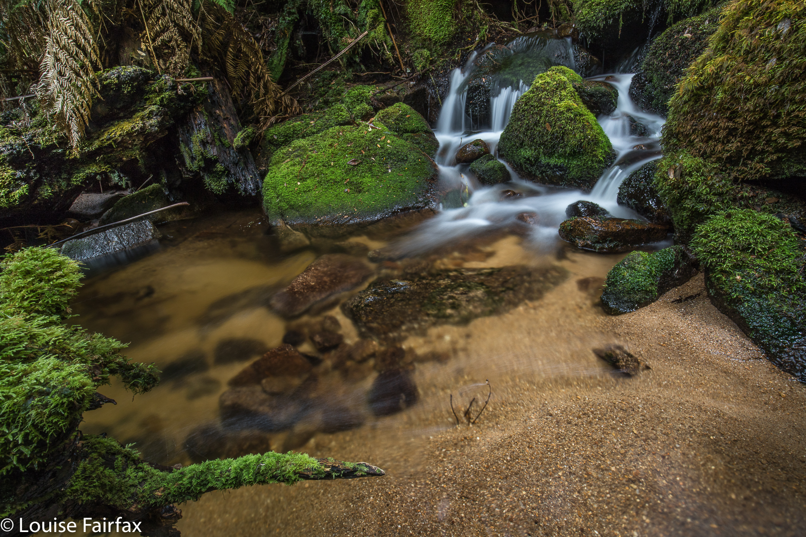
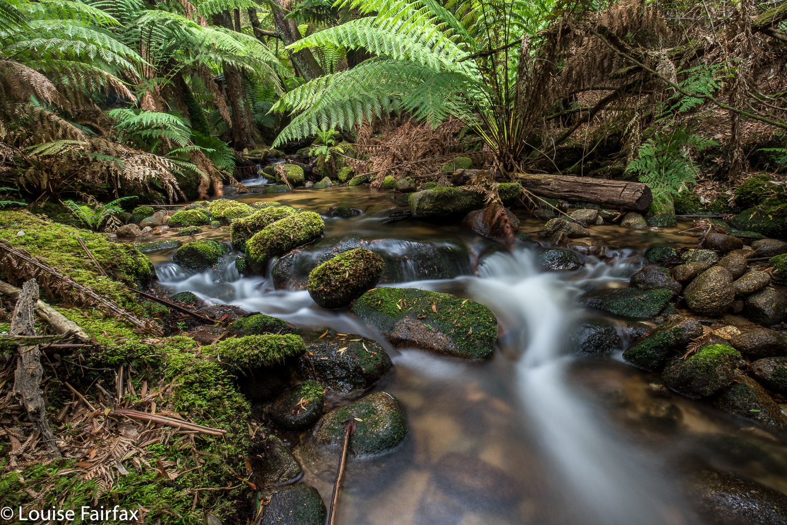
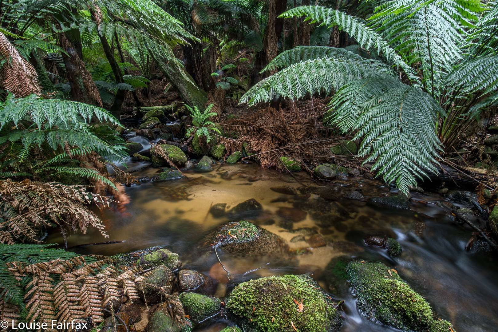
The final hundred or so metres were hilarious. I used to run 100 metres in 12.2 seconds. I think we took over ten minutes to negotiate the final hundred into the falls – or was it even longer? I didn’t time it exactly, We had started to lose our belief in the existence of what the map was promising, as we could neither hear falling water of any magnitude, nor see the telltale white glare up ahead. At last I gave a victory shout. We had done it. Before that, however, there were squeals of joy, like infants when they see the birthday cake. Once we descended from the heights down to the river, we felt we were in fairyland. It was utterly wonderful, and we were yelping in our excitement, lining up pools and cascades we would shoot on our way back. At that stage, we both wanted the final goal first, and these other spots could follow.

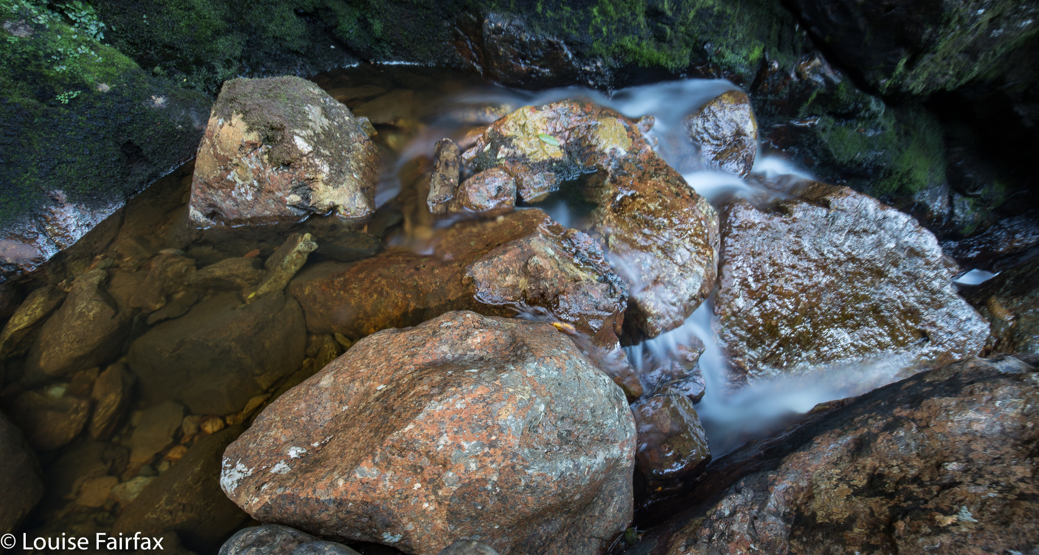
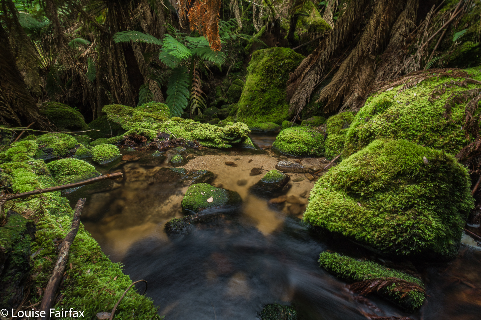
The way there took, as said, 1 hr 40 mins (walking). The return, where we spent less time track finding, 1 hr 20. These times do not include tag maintenance, hesitations while route finding, photography or eating. When you add in those things, the trip was 4 hrs 20 minutes long – and that does not include lunch. We had that back at the car. At “lunchtime”, we both grabbed a rushed few bites of chocolate bar, and then set about photographing, which we did for forty five minutes (so my phone’s track data tells me). We probably spent another thirty, at least, photographing pools on the rebound.


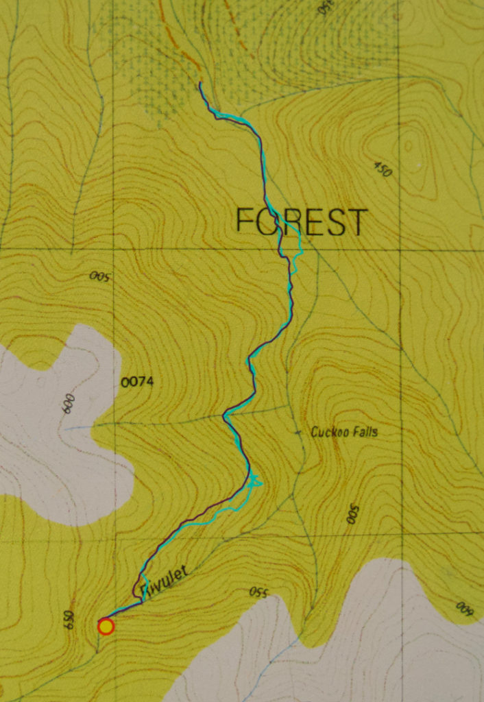
There is a curious feature about the photo I have included. Can you see there’s a falls labelled Cuckoo that we didn’t visit? And that we are claiming to have visited Cuckoo Falls at the far end, when it is not labelled such? The far end Cuckoo Falls are the falls of the 1:100,000 map, and also of the List Maps, government site. These falls on this map seem to be a speciality of some 1:25,000 maps. I am still seeking an explanation of this intriguing matter. We were totally happy with the falls we found and the photos we took, and did not have time to explore these other, nearer falls on this occasion. Besides, it’s nice not to exhaust an area of such beauty as this, and to have an excuse (as if one needs it) to return. If you know the story behind the two Cuckoo Falls, please let me know in the comments if you can.
Post script. I have now been told by a very experienced person from Scottsdale that the “lower” falls marked and labelled on this map do not exist. They need to be omitted from List Maps. I guess someone made a transcription error at some stage, and it has been handed down.

Ralphs Falls 2018 Feb

Ralphs Falls, Feb 2018.


I didn’t think that the walk to Ralphs Falls was going to be particularly exciting (being a mere six minutes along a track from the carpark), or that the falls themselves would offer much, being a thin sliver down a brown cliff, but I am one of those thorough types and I like to see everything at least once for myself. I didn’t think Ralphs would be exciting at any time of year, so why not do it in summer? At least we’d had some rain last week. You never know your luck. And if we’d been certain of a big flow somewhere, I can think of much better places to be than a waterfall that has a single narrow line of water dropping into a space that you can’t see below. So, our adventure for this week would be Ralphs Falls, an attempt at Cashs (or at least a viewing of the Cashs Gorge), and then Alberton Falls.
(see http://www.natureloverswalks.com/alberton-falls/ ).

Cascade above Ralphs Falls
Off Carrie and I set. We were both struck by the extreme beauty of the forest. This, for us, outweighed anything the waterfall might or might not bring. The forest was an end in itself. Luckily I had asked Carrie to meet me nice and early, as, even at this early hour, the sun was casting shadows that were a little too bright for good photography. We enjoyed the fairy forest without photographing it. The falls were as ‘exciting’ as we expected,  but we were glad to see the view, and to make the acquaintance of this Fall.

On we continued around the circuit, wondering how long it would take. (Twenty four minutes, actually, which wasn’t a great deal of bang for the driving buck, but don’t worry, I extended it, as you will see). The route remained wonderful, with a sense of space beyond the trees that felt lovely. The forest floor was really open and clear – like a parkland – and we delighted in it. We got to a point where one could go down the steep, unknown spur to try to see the base of Cashs Falls, but we were both filled with curiosity still to discover what could be seen from above. Nine minutes’ walking  after leaving Ralphs Falls, we arrived at the Cashs Gorge viewing platform, where we learned you could see precisely nothing of the actual falls. Hm.


The situation had not been right to go down the first spur that we could have followed (and then traversed in to the base). I had left a few things at home – like suitable clothes if it got any colder, and had forgotten to charge my gps which now read at 8%, bespeaking a crash at any moment. I had had a fire on my property in the late hours of Friday and early hours of Saturday morning, with very little sleep, and was not in a good headspace. Meanwhile, Carrie was wearing sneakers rather than boots, and it looked very steep down there. And, my tripod was sticking out, and would catch on all the bushes. I needed to have a different pack which could protect it if I was going to do THAT kind of bushbashing. However, now that we could see that we couldn’t see, we were disappointed, whilst still rejecting that first route to visibility for the above reasons.


Therefore, I suggested we follow the big spur opposite around to where it might give an opportunity of approach on that side. It was a beautiful route through more surprisingly wonderful forest, and we happened upon a pad, which a handmade sign said belonged to a Rattler Range traverse. We left that though, to do what I wanted. However, my tripod kept getting stuck here, too, once we started to lose contours, so we decided to come back to Cashs on a day where the flow would justify the bash, and on which I had a suitable pack for my tripod. Just in case, it would also be nice to have a gps that wasn’t going to faint. We had no risk of getting lost – I could have drawn a contour map in the dirt had Carrie wanted one – but for knowing whether you are above or below your destination, and other fine points of detail, a gps is of comfort. We went back to the car and fed her before doing the next falls.


Alberton Falls 2018 Feb

Alberton Falls Feb 2018
The web remains curiously silent on the topic of Alberton Falls, and I am an incredibly curious person who likes visiting outré places. Alberton Falls yelled out its challenge to me: “Come and get me if you can.”
I suspected that this wouldn’t be a brilliant mission with respect to photography, but, well, you never know, and we did have a huge storm last night, with a cloudy, possibly rainy day forecast for today. Of course, seeing’s we were there to photograph, the sun shone brilliantly nearly the whole day. The aim with this waterfall was, more than anything else,  just to get there and to satisfy my curiosity. Any good photos would be a bonus.

Off we set. It seemed by the sound of things that Carrie was not appreciating walking through marshy button grass in summer heat. Early on she thought she heard a snake. I forged on, trying to pacify her by saying they’d bite me first. I don’t know how convincing I sounded. It seemed she was of the opinion they could bite either of us, and more likely her, as I had on gaiters. I kept pointing to where the forest began: “See, just there. Once we’re there we’ll be in lovely forest with no snakes.” And I was right. The forest was really beautiful, and we didn’t see one single snake. Now we could both start enjoying ourselves.

Once we were in the forest, we just followed the creek down. I spotted signs that someone had once walked this way, and Carrie, whose eyes were not so glued to the ground, started spotting old bits of faded, rotted tape, many of which were above my head in height, so I guess a kindly giant put them there. They were not to be relied upon, but that’s fine. I was navigating using the normal methods, but their reassurance was a friendly one.

Eventually we came to the “falls” – except that nothing much was falling today. However, just as you can tell that a building was once beautiful by inspecting its ruins, you could tell that this waterfall would be a lovely one when the water was flowing. The drop away from us was huge. We looked out from where it exited the rainforest past a whopping cliff and out, out into the way way yonder. We were both determined to have some photos for our efforts, so snapped away just because that’s what you do when you’ve arrived.
As we both enjoyed the magic rainforest, which was surprisingly open, and so beautiful that we spoke in whispers so as not to spoil the feeling of peace and serenity that prevailed, I took us on a route back to the car that maximised our time in the forest, and thus minimised our time in open land. (The crookedness of the line exists because I was using the parts of the forest with almost no undergrowth, as opposed to areas where this was not the case.) To the north, the land dropped to eternity below us. It was a gorgeous forest and a fun adventure, and we have now documented a previously web-neglected waterfall, and had the pleasure of experiencing a place that not many others have seen, one suspects.

I nearly forgot to add: it took us 23 minutes to the falls, longer on the way back, due to weaving and more map consulting than on the way there.