Cam Falls 2017 Aug

Cam Falls and Owen Brook Falls. 24 Aug 2017.
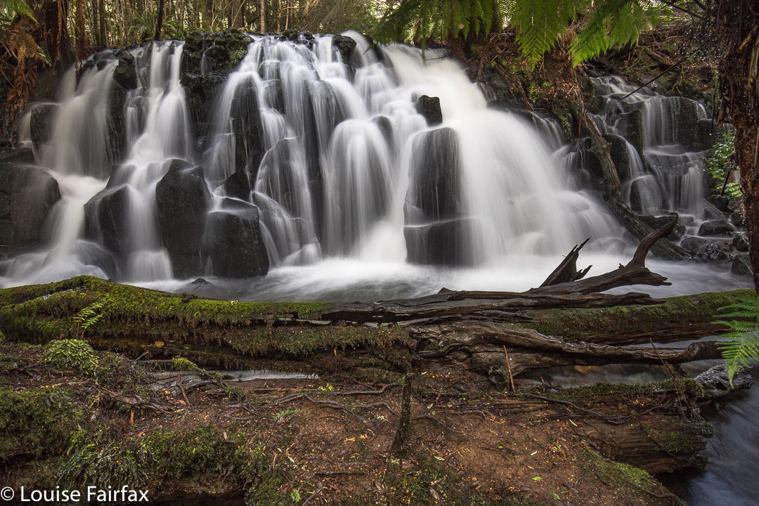
Being somewhat new to the waterfall bagging business, I was really confused about whether the Cam Falls and the Upper Cam Falls were the same thing. Many web sites depict a waterfall and name it the Cam Falls, but the picture is actually of the Upper Cam Falls, which is confusing if you’ve come in from the outside. The Waterfalls of Tasmania website does not list the Cam Falls as either a documented or an undocumented feature of our environment. Wikipedia kindly has them both, and the wiki-map cleared up for me the confusion about where each one was. See the map at the end of this article.
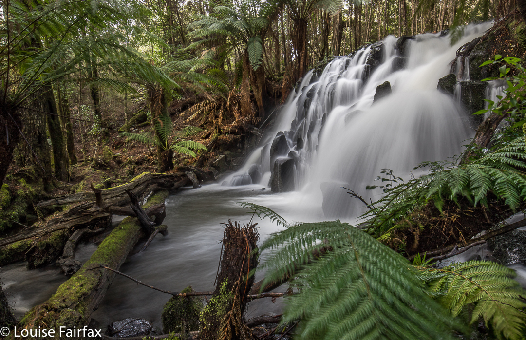
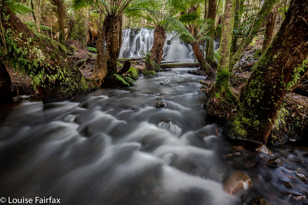
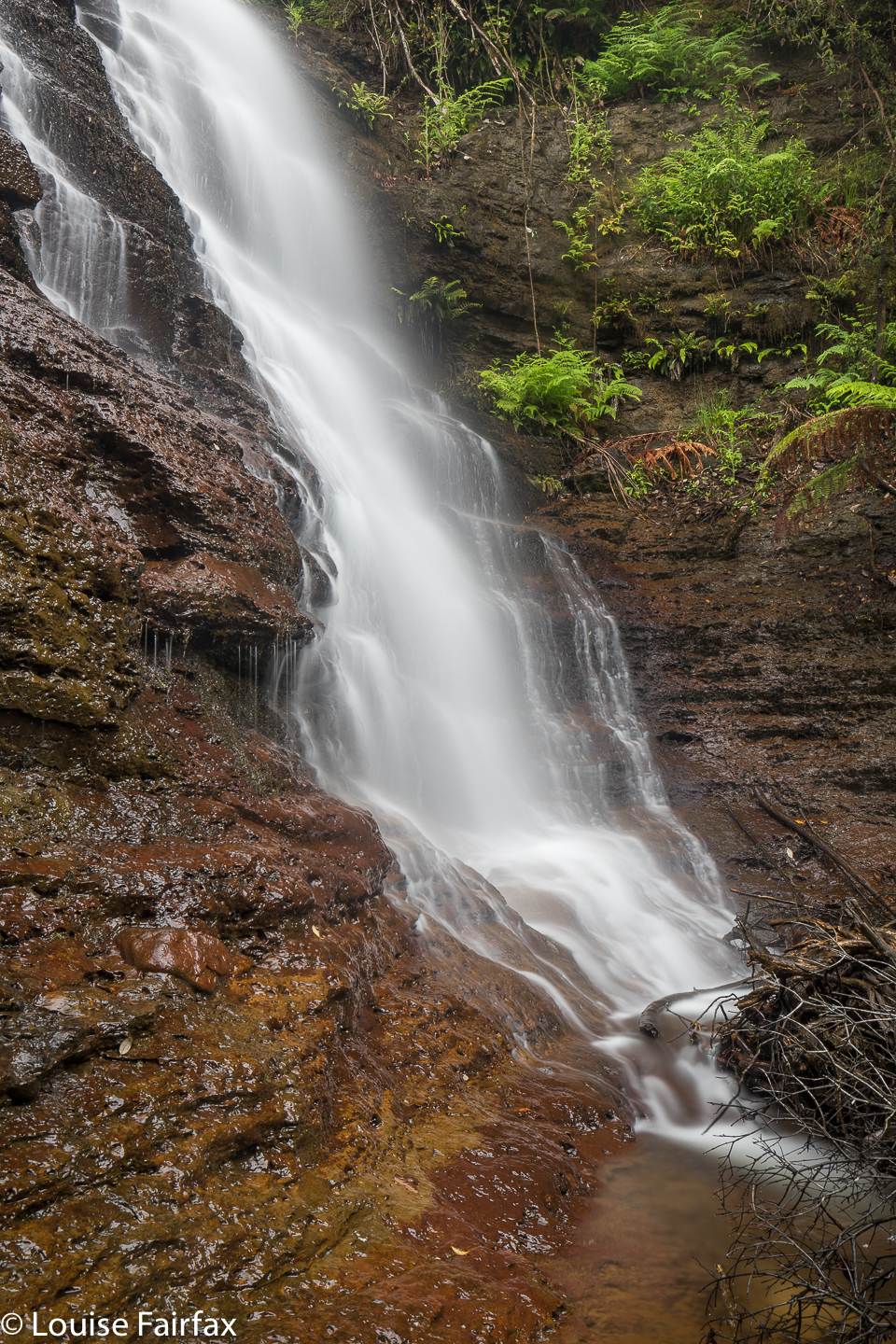
We had a free day on Thursday. It seemed like a nice waterfall sort of day. Off we set. I decided to tackle the easy one first (Upper Cam Falls), so that we didn’t return from the drive empty handed. Good idea. What a delightful waterfall this is! For directions, see
www.natureloverswalks.com/upper-cam-falls/


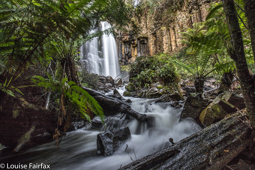
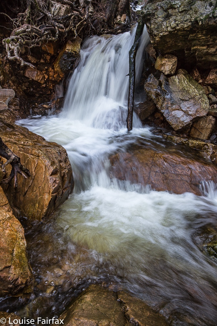
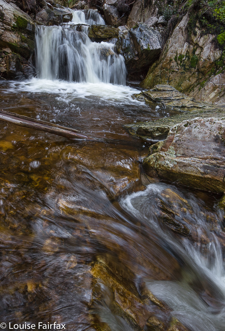
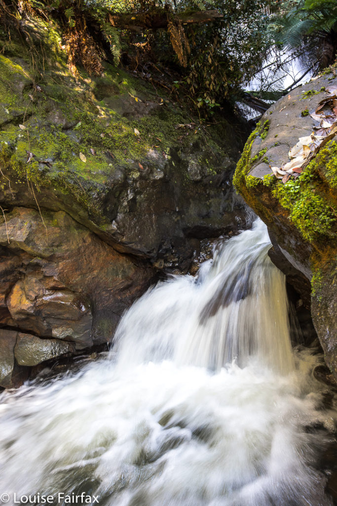
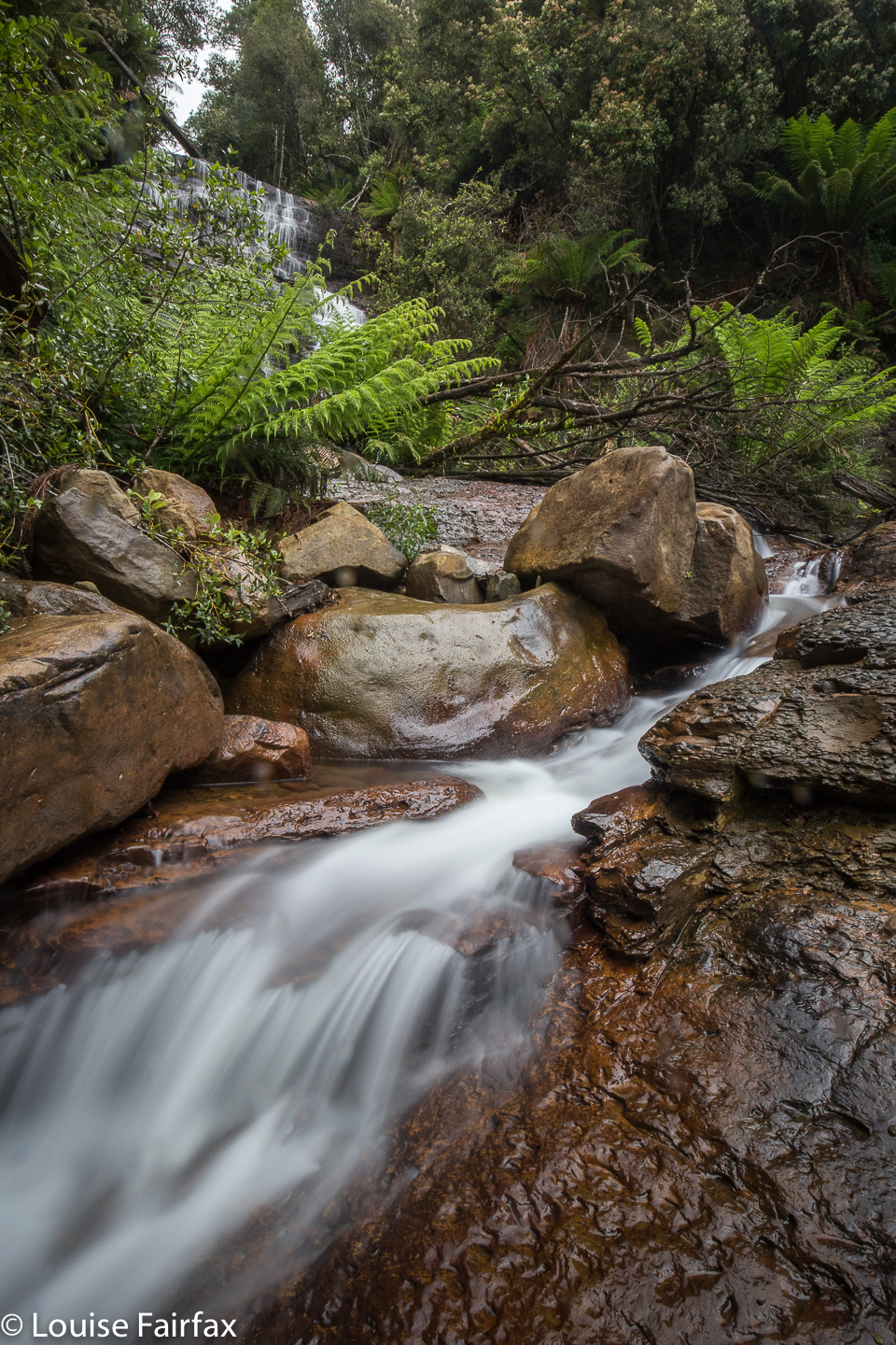
These are the Cam Falls (without an “Upper” prefix). I cannot find another web image of these falls.
To get to the Cam Falls, we travelled along the C103 until its intersection with the C101. Where they met, we turned left and went to the end of the bitumen.
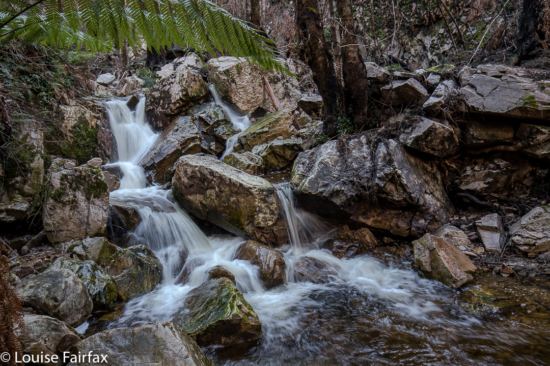
We parked by a green, corrugated shack (which I knew about from a different useful post), and I went to ask permission to see the Owen Brook Falls, which are in a paddock behind the house. My web source said this person was friendly and granted permission. However, there was no person, and the shack was broken down and vandalised. I decided to see the Cam Falls first, as these were also in walking distance from the dwelling, on the other side. This took a very long time, as I was super cautious descending the excessively steep and not-necessarily stable slope, choosing trees that might take my weight, finding footholds that wouldn’t give way. What an impressively steep gorge!! There is a railing up the top to allow you to view and lean a bit without killing yourself, but I would not take children near this place unless they were on a lead. I would also not descend unless really competent and experienced in this kind of untracked steep terrain. If you do, please remember that you do so at your very own risk and don’t think it is someone else’s responsibility to keep you safe. My husband did not attempt either descent.

The Cam Falls were on the East Cam River. The Owen Brook Falls are on Owen Brook, which joins the East Cam just below both falls. The gorge area was fantastic and I would have loved to have explored for longer, but we hadn’t brought our lunch, and I was (as usual) starving by now, so we left, contented, and eagerly headed for our next treat – savoury food at ETC, and dessert at the Raspberry Farm. We love this post-walk ritual. Tessa considers herself to have bagged three more falls.

Gads Falls 2017 (Lower)

Gads Falls 19 August 2017
Gads Falls truly intrigue me. I first read about them in a website that made them sound simple, although it said they’d been destroyed by fire, so wait a while. However, following the recent reopening of the Mersey Forest Road, I saw web shots  depicting images of what could now be seen.


Meanwhile, I heard an old-timer from LWC talking about them as we passed nearby last weekend, and he commented: “It depends what you mean by Gads Falls. There are many falls. The first few are easy. They get harder as you go along, and the final one (here he sighed), that one is very, very hard and only for the brave.” He shook his head. Hm. Now I was curious, to say the least, although, as I don’t see myself as being very brave, this wasn’t like a dare or goad. He implied it was very steep and that the scree was loose. A different old-timer pointed out the real ones to me, much higher up than any short walk would be; you could just see them peeping out very high above.


On Sunday, my husband and I happened to be passing by the base with time on our hands, so I decided to pop in and do a recce. As I had no idea what to expect – wasn’t sure how to interpret what I’d heard – and as this was therefore only a recce, I didn’t bother with a tripod. Thas quite good, for what I encountered just getting to some of the lower cascades, was very, very steep and loose, with slopes plummeting down into the various little falls (if you wanted to reach their base, and I did). River crossings needed two hands for balance. No single tumble would kill you, but it could easily break a bone or two, and I wasn’t in the mood for that on Sunday. Also, I didn’t know exactly what would happen if a landslide began, and my curiosity didn’t extend as far as wanting to test that one out. I was very cautious indeed, which meant that the short time indicated for each direction was way under what I took, especially as I did indulge in a few photos of each cascade. Meanwhile, I plotted my attack for what is called Gads Falls on the map, the ones indicated by my second old timer, and which are much higher than any web photos I have seen. A third knowledgable person told me the only photo he’s ever seen was taken with a drone. I’ll let you know if I get to the top ones. Don’t hold your breath waiting.


Re the spelling: Gads Falls seems to be favoured by Tourism Tasmania, whilst Forestry confused people by writing Gadds Falls on a signpost (not for the first time have sign posts in Tasmania confused people by having a cavalier attitude to spelling. Poor google has enough trouble trying to find our little island without that!). As ever, I let the map have the final say, and my map, having not consulted Forestry, spells it Gads Falls, so, Gads it is.
To go to the easier, lower cascades, park in the quarry to the north of Gads Creek. You can do as I did and bushbash to the creek and cross over, which is tricky in these winter high flows, or do yourself a favour, as I did on the way back, and cross the creek on the road, and proceed upstream from there. You will come across the odd marker that has survived the fire, and see bits of remnant track, but the distance is only a few hundred metres, so just work your way upwards. You can usually see where other humans have trodden. The moss has been mostly burned, but the cascades and stream are still very attractive.

Owen Brook Falls

Owen Brook Falls 2017 Aug.
Our trip to the Owen Brook Falls (south of Burnie in the Ridgley area) began with a trip to the Upper Cam Falls (route details in the blog of that name, viz.: www.natureloverswalks.com/upper-cam-falls


From these, we returned to the C103 and continued northish until that road intersected with the C101. At this stage I was a little unsure as to what to do next, but there was a very nice man nearby, a local, and I was wondering if he might be the person I needed to ask to get permission from to go to these falls (or might at least know whom I should ask), so I asked him about the finer details. He was very helpful, muttered nothing about private property or keep out, and told me exactly where to go, which was to turn left onto that branch of the C101, and to drive 3 kms to the end of the bitumen.
At this point there is a very rundown ex-house, where one used to ask permission. With no-one there, I just went across the paddock behind said “building” and headed for the falls, which were, as you can see below, rather hard to get a good view of. You would be mad to not take in the Cam Falls along with Owen Brook, as they are very close to each other, in gorges that meet just below each fall. (The Cam Falls were on the East Cam River. The Owen Brook Falls are on Owen Brook, which joins the East Cam just below both falls. ) Take your lunch, and then you can explore the gorges more than I did. Hunger pulled me away.
This is the base of the Owen Brook Falls from as near as I was game to go in the slippery conditions of the day. I was unwilling to climb any of the mossy, near-vertical rocks on offer to try for a better shot of the falls, which are huge, and whose base part A can be seen at the top of the image. I was also hungry, and if you haven’t yet worked it out, my stomach rules. This was as good as it was going to get this day, and this is the only web image of the Owen Brook Falls I can find, so you are not allowed to complain. 🙂


The top two pins are the Cam (R) and Owen Brook (L) Falls. The bottom pin locates the Upper Cam Falls.
See also www.natureloverswalks.com/cam-falls/

Upper Cam Falls 2017 Aug

Upper Cam Falls 2017 Aug

Many people count this delicate waterfall as one of their favourite falls anywhere – – or they did before some selfish vandal came in and hacked down some ferns to get a better instagram shot. Now the name caries with it a certain odour of corruption and distaste, which is a pity, as they are beautiful. It is nonetheless fitting that they kind of lie low for a while, so we can forget the damaging effect of social media on our environment.


Note, these are the Upper Cam Falls, sometimes incorrectly called the Cam Falls in the web.


To reach this gem, we headed south from Burnie along the B18, driving past Ridgley of Guide Falls fame, and continuing on to Hampshire. Here we turned west onto the C103, and continued until the western road swung to the north. At this point, Lockwood Rd is to the left, and this is the road you follow until a yellow boom gate stops you. The falls are then down to your right in a ferny glade. You can hear them from your car.
For a discussion of the route to the Cam Falls (and photos), please see the blog www.natureloverswalks.com/cam-falls

Westmorland Falls 2017, 2018

Westmorland Falls 7 May 2017.
It has been several years since I last visited Westmorland Falls, and I have wanted to return to take better photos. But then we had the big flood and the track was closed. At last this weekend I had my chance to return.


We drove along happily, delighting in the autumn scenery of rural landscape dotted with red and orange and yellow trees, and of the fresh snow on the Western Tiers. It had been nice and warm at home with our fire in the kitchen, so, in the comfort of the car, we did not translate that delectable white into the inevitable chill in the air that wind passing over it can bring. Brrr. We very quickly did our maths when alighting from the car.


Westmorland Falls; picture from Dec 2018 when the flow was better
Luckily, my happy memories of Westmorland extend to glowing images of all the fungi we found on the previous visit. These did not disappoint. The falls, however, were another matter. The devastation of that area is still all too visible, and the falls themselves seemed shockingly barren, stripped of the framing ferns. Fallen trees were all too abundant at the base. But at least they have been opened back up and heaps of repair of repair has been done – even if they have left, seemingly forever, two gigantic, unsightly and utterly unphotogenic bags at the base of the whopping viewing platform that has been built.
Repair was a smart move. We met about ten other people who were there to see the falls, including Japanese tourists. I hope all of them supported the local shops by buying food in Mole Creek or Chudleigh. If you want money from tourists, you have to give them something to do to keep them in your area – and something to spend their money on. By repairing flood damage so that tourists (and Taswegians) can reach attractions like waterfalls, you are hopefully supporting the local businesses.


The sign said two hours return. How do they know how long you want to spend photographing, or whether you want to have lunch there or not? I hope it is more helpful to tell you that I took 26 minutes in each direction, and maybe an hour photographing on top of that. As it was pelting with rain, I ate in the car after I’d finished. In 2017, I took nearly three hours, spending all the extra time lying in mud trying to fit under delicate mycena. Luckily the leeches weren’t out, or I would have been covered in them. (2018, Dec, they made up for it. I flicked off leeches the whole trip home. It made driving a challenge).
In 2018, I chose these falls on a day when it was due to rain all day. They were perfect for that, involving not too long a walk, and on a track that doesn’t have too many overhanging shrubs to drench you as you go past.


To reach the falls, head south from Mole Creek along Caveside Road for 5.9 kms. Turn right at a road signed Wet Cave Road, which the lady on google maps will tell you incorrectly is West Caveside Road. At the T-intersection of this point, there is your first sign to the falls you are wanting (spelled incorrectly). From here on, every turn has a sign. The sign that says you’ve arrived is spelled as per the map. (2018, I came straight in from Chudleigh instead of going via Mole Creek. Bad idea. The signs to Caveside dump you, abandoning you in the middle of beautiful countryside. It’s much clearer if you come via the Mole.)


As hinted above, there seems to be a great deal of confusion about the spelling of these waterfalls. I am using the spelling that is on both the 1:100,000 and the 1:25,000 maps. They get the call. Surely they are careful enough to spell the beastie properly. Not so the Meander council, which has some road signs directing you with the spelling having and e (as in Westmoreland Falls) and some without, as I have used consistently here, in line with the maps. I note that Waterfalls of Tasmania uses the other spelling. Google is rightly confused, and lumps all references in together – very wise. Official government map departments use the correct Westmorland spelling, but I note that the Touring Tasmania site uses the incorrect spelling. Mole Creek information uses it correctly. Whatever spelling you use, Google maps will tell you it doesn’t exist, and will try to direct you to some place in America, no doubt selling stuff that will last a short time. The falls are not what they used to be, but they are still worth seeing, and the fungi on the way are terrific.


Westmorland Falls Fairy Forest.
Route data: 1.75 kms in each direction, with over a hundred metres climb (and some climb on the return journey as well):