Sandbanks Tier 2013 Dec

Sandbanks Tier 16 Dec 2013

Elin above the summit of Sandbanks Tier
We were a bit frustrated at having only climbed one mountain, and the weather had now cleared up to be a magnificent day, so, even though we were passing by Sandbanks at nearly five o’clock, Elin and I decided to bag it. One extra point for both of us. My husband found our pace over the uneven ground a bit hot, so read the newspaper in the bush instead.
 
Sandbanks from below

The mountain looked uninviting with its scree and dry wasteland, but a point is a point. We were also unsure as to exactly which peak would be the summit, but headed for the one that seemed indicated by the VERY rough sketch in the Abels book (pictured above). 

Summit view of high land nearby
We had huge fun clambering up, and I was delighted that my calf didn’t slow me down TOO much, although I was pretty cautious, still protecting the muscle that was no longer able to function properly. That said, we were on the summit in 36 mins, and took even less to get down as my confidence in my calf grew. Elin, being an orienteer, danced over the rocks.

The lake below was beautiful in the late afternoon light
The view from the top was stunning. I had never imagined that Sandbanks Tier could offer anything, but there stretched out before us was not ony a wondeful expanse of shining blue water, but we could see Geryon, Acropolis, Ossa, Pelion East, Olympus, Byron, Cuvier and, to really cap it all off (sorry), Frenchmans with no shelf, but definitely the cut-off head of Frenchmans was sticking up clearly. I used my big zoom to get the mountains so we could show my husband that night. Now we were far more satisfied. Our trip had yielded two mountains. Home we went for a late dinner.

This is one of the zoom shots I took for B. It shows the mountains that we looked at from the west, namely Acropolis, Geryon and more, and here we were seeing them from the east as part of the same trip. It was rather special.

Abbotts Lookout 2013 Dec

Abbotts Lookout

Mts Anne, Eliza, Lot. Sarah Jane (from R to L)

I was very disappointed to discover that our group had not obtained a key to drive up the road to Abbotts Lookout, which would have then given us time to also summit Marriotts. Instead, it was announced that we would walk up the road to the first, and not have time for the second. Road walking is not really one of this bushwalker’s favourite activities. I’m a BUSHwalker, not just a walker. Oh well.

Looking west to the Thumbs

 The negatives of thwarted expectations and hopes (and one less summit) out of the way, I have to say that if you’re going to walk on a road, this is the one to choose, as all traffic is prohibited, and it could not be lusher or greener if you paid someone to water it daily (that’s already been taken care of). The real test – would I do it again? – has the answer, “most definitely yes”, and would do it again even next week if the opportunity arose.


The trip up, I really enjoyed as I do love exercise per se, and whilst strolling drives me crazy with impatience, being let off the chain and allowed to meet at the top gave me licence to just enjoy going at my own pace. Had I not been lugging a couple of kilos of camera gear plus warm clothes for the top, plus our lunch, I would have run, but at least I was not required to slam on the brakes or wait for long stretches as we went up the road, so that made it a pleasant outing.
At the top, if you could ignore the “Tourist Award Winning” structure, which today, like almost every other day, had not one single tourist (they paying about $100 to be driven up the same road and let inside the building), the view was monstrously fabulous. What a shame they don’t man their white elephant. We would have all very happily bought coffee and cake from the machine we could see on the bench inside. As it was, we sat on the verandah and alternately took a few more shots of the stupendous view and ate our lunch. Several members of the group took just over two hours to get up the mountain, and nearly as long to get down, so it ended up a full day’s activity. 

Telopea truncata

On the way down, I had a lovely time dreaming, singing aloud as no one was with me to get disturbed or annoyed, and gazing at the scenery. Up the top, where it was higher and dryer, with stunted vegetation (mostly dwarfed eucalyptus coccifera with a scrubby understory) and far more visibility, the road headed straight for Mt Anne. I walked along, my attention captured by one of the best views of her I can remember, while to my right was an eternity of white bauera that looked like a snow storm with so many tiny white petals, light as snow flakes. Walking gave me time to fully digest this mass of delicacy. The greens of cutting grass made a marvellous contrast to the otherwise olive colours on offer. Bright yellow pultenaea juniperina stood out amongst the green with white dots, as did the brilliant red of numerous telopea truncata. Naturally, I stopped a few times to photograph. Soon enough I reached a corner where direction and altitude changed, and first I encountered a wonderful myrtle forest, and after that the forest became more truly rainforest. It seemed like the variety of ferns was endless, each one with a slightly different shade of green, but all greens being the lime-spring green that always lifts my spirits. The fronds shook in the wind that had changed from raging on the higher slopes to a more pleasing breeze once in the protection of the bigger trees. The moss seemed as if it were at least ten centimetres thick – fresh and wonderful – and it spread sidewards to cover everything but the piece of road used for the few vehicles that are permitted that way.
So, whilst it seems silly to walk on a road when driving is possible (allowing time for the real bush), I do have to say that I enjoyed this little exercise, had a great workout, and the scenery was utterly wonderful. Given no time constraints, I would opt to walk rather than drive even if someone did give me a key. This is definitely a family-friendly walk.
To reach the start, take the Styx Road, shortly after Maydena, cutting under the main road. Roberts Road, which you walk up, is left off Styx Road. Park at the locked gate, and walk upwards to the top. The actual summit is a mound of rock on the right, just before you reach the building. The building, although a blot on the landscape, at least serves the function of providing a dry verandah and wind shelter for having lunch, if needed.

Jubilee 2013 Dec

Mt Jubilee Dec 2013

Richea scoparia from Mt Jubilee

Isophysis tasmanica
Having driven down from Launceston in a slow bus with several long stops, and having slightly misinterpreted instructions on how to get to the start of the walk (roads not being on the map), we were not ready to set out on our little trek until a fairly disastrous 11.25 – almost time for lunch, especially for this hungry person who had had breakfast at 5 a.m. This did not augur well for making our destination, and all my misgivings were realised as I saw how far we hadn’t got when we did have our midday meal.

 In fact, I feared that we weren’t even going to make Mt Jubilee, let alone the further high point of the Jubilee Range, the stated goal. Was a mass of dense melaleuca and bauera scrub to be our final destination? Would we get up to a view? Happily, the answer to the first question is “no”, and the second is “yes”. We did summit Mt Jubilee at least, and thereby gained a glorious vista. The club did not, however, do the times said in the book, and needed 2 hrs 30 mins plus breaks to get up (four hours in total), a bit less (and fewer breaks) to get down. Everybody adored the expansive views and the spacious feeling on the summit, to say nothing of the splendid scoparia in flower in numerous pockets up the top. I loved the rocky outcrops with their hippy lichen hair dangling as well. We stayed on top a lovely long time, absorbing this wonderful view, and having the names of the surrounding peaks pointed out for us by people who are far better than I am at recognising old friends from different angles. This mountain is not high enough to be an Abel; not even of enough interest to the point-allocation powers that be to be worth a single point, but it is a wonderful mountain, and one I would love to sleep on for the splendour of its views and for what my imagination can picture it must be like at sundown. Next time I want to be there with my proper pack and tent.

Getting nearer. Up on the high ridge with views at last.


Instructions on how to find the roads that are not on the map:
first take Jubilee Rd off Styx Rd (a right hand turn). Driving along this road, there is a left turn on offer, but with a clearly visible fallen tree only about 50 metres in. Obviously, don’t take that road. Then (and especially if your instructions say “Take a left turn”) you might be tempted to take the next left, which does go somewhere. We have thoroughly explored this one for you. It does not go where you want. The third offering to the left is a Y-shaped fork, where you may now take the left hand option, and, where it seems logical in terms of your final destination, look carefully for the “cairn” (a tiny gathering of dark grey rocks, very subtle, about 15-20 cms high at this time of writing) and a couple of rather faded ribbons. It is well worth the trouble of locating this starting point, as the pad (not track – you still have to use carefully-honed observation skills to stay on it) saves a lot of time that would otherwise be wasted finding the best route through the rather tightly-knit scrub. Do not undertake the route if you are not confident of navigating, as you can’t rely on seeing the pad, and I can guarantee there will be times you need to consult map and compass in order to get yourself to your destination.

Millers Bluff 2013 Nov

Millers Bluff Nov 2013


Epicurus said (a few thousand years ago – when no one had heard of Millers Bluff) that it is more important to have someone to eat with than to have something to eat. With the silly side issue of starving to death omitted, I absolutely agree. And I would add in a similar vein that, although sitting on a mountain is a wonderful thing in itself – solo or with company – it is often the case that the company we have on a mountain is more important in forming our emotional reaction to that mountain than the mount itself. I have summitted many mountains solo, but my favourite experiences are always ones where I’ve shared the mountain with like-minded friends.

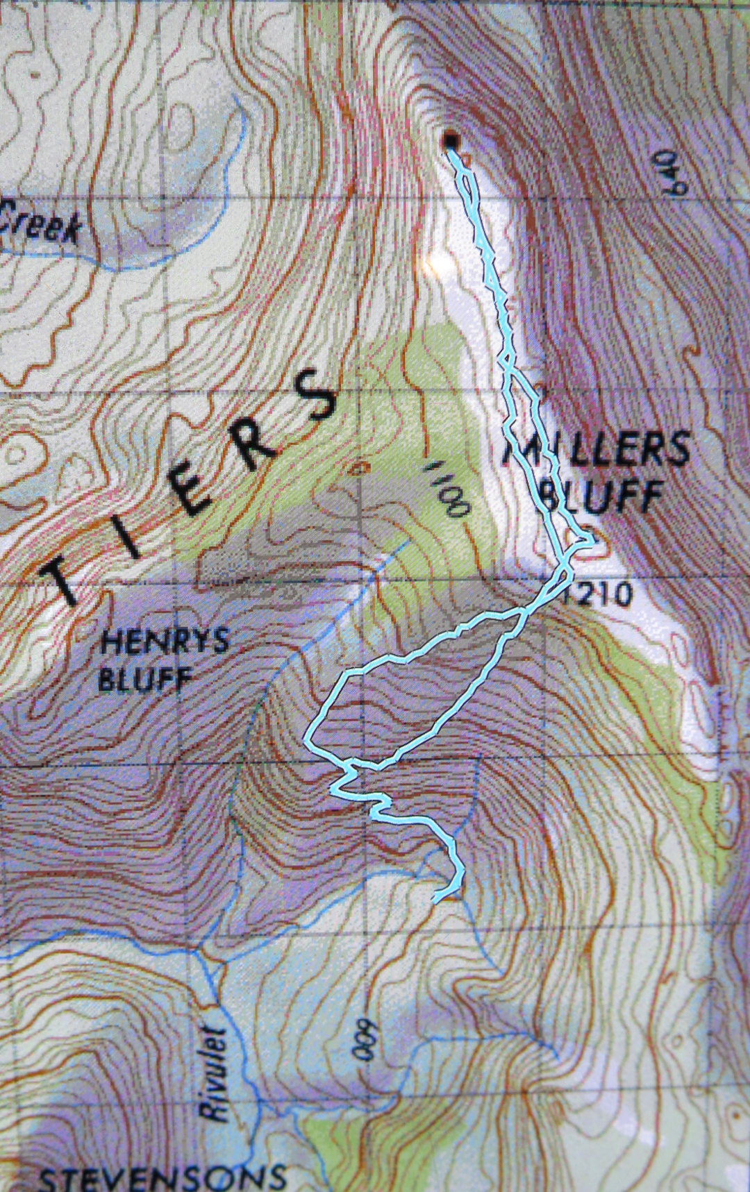
And so we come to Miller’s Bluff, a bitch of a mountain, a horror fight through prickly hakea, stabbing scoparia, tangling bauera and impenetrable walls of green junk that muster superior defences to defeat our best efforts to push through it. How many minutes did we spend in our monster epic to reach the summit perched on a rock looking at a sea of attacking, knife-edged greenery wondering which would be the route for the next 20 metres that might allow us to progress to the next rock where we could do the same? The actual summit never seemed to get any closer. In a trip that covered only 16 kms, we took 14 hours 36 in total, 9 hours 41 of which were spent in movement, according to my watch. My gps says only 5 hours were spent in movement, but I guess that just means we were moving so slowly that the system failed to define what we were doing as “movement”. (I guess I didn’t stop my stop-watch every time we halted to make another terrain decision). It was the dubious progress of snails. Lunch was only short due to lack of time; we didn’t get any dinner, and snacks were few and far between. The blank time was spent a little in regrouping, and quite a lot in making decisions about how to move forward. And I was with highly experienced and competent walkers.


The shadows were already lengthening by the time we reached the summit, and we got to enjoy sunset from the top, as we took over two hours (in each direction) to travel the slightly more than two kilometres-long ridgeline connecting the “nearly summit” to the actual summit, a mere 2 metres higher. The descent did not begin before we had passed nearby the fake summit again. I think for a mere two metres, it would be well worth tampering with the environment and gathering a few rocks; however, the views were much better from the real summit, and my favourite views were had along the ridge line coming back to the false one. There was a lake in the distance, beautifully lit by the crepuscular rays of sunlight, and the tiers to our right made wonderful silhouettes. That was a sight well worth savouring, and luckily we had plenty of time for that. Had someone heaped rocks on summit one, all that would have been missed, as would the adventure of descending in the dark.

For me, to sit on a highpoint in the glare of the midday sun is a bit of a waste of a mountain; the fact that it took us so long that we got to see sunset from the top was a bonus. I am never going to climb this mountain again, or be in that spot in the middle of a bed of green nails at sunset again; it’s good that I’m satisfied with the photographic memories I have. The collection will not be supplemented :-).

As we began our descent through the rubble, on went the head torches ready for complete darkness. Now we got to fight “blind” like knights of old on some valiant mission. At some stage someone announced it was her bedtime. I looked at my watch. It was now 11 pm. No wonder I was hungry. And tired. I like to be in bed by 10. I’d arisen at 5 in order to at our meeting place on time. It was already a long day. Blood sugar was not miraculously rising in the absence of dinner. On we pushed for another hour and three quarters.

I was dangerously tired on the way home, and after a momentary blackout where I started veering off the road, I bumped up my music to a volume that could possibly be heard for a radius of a kilometre, and drove at a mere 50-60 kms/hr for safety, so did not get home until about 3.15 a.m., and was not in bed before 3.45, as my poor dogs wanted food and attention, and, despite the rather odd hour to be showering, I decided it couldn’t wait until official morning.
Today, Sunday, I am weary but happy. That was a grand epic and I am delighted that I have found a group of similarly crazy people to do things like that with.

 
I nearly forgot to mention a rather scary incident that happened while we were climbing up. There were two of us a tiny bit ahead, which turns out to be fortunate, as no one was yet directly behind me. The guy had chosen a path to my left; I had chosen to ascend via an interesting chimney arrangement that offered good handholds at the top, using a crack that was 15-20 cms in from the edge. I tested it, as one always should. It felt solid, so I put all my weight (not much) into it to lever myself up. Suddenly this seemingly sturdy rock mass split away from the parent and I felt myself falling backwards down a steepish incline, closely pursued by a hunk of rock as large as a man’s torso. I find it astonishing the way that in an emergency like that, the body is able to push off nothing, and do superhuman feats. I pushed off air to lurch myself sideways so that the rock just grazed past me as it careened down the slope past me. I then lived in absolute terror for a second or two as I didn’t know where the others were – the scrub was too thick to see clearly – and I knew with certainty that that boulder would kill anyone it hit. For quite a while after that, my legs were jelly at the thought of what nearly happened. I include this here as a reminder of what one should always know and do anyway, which is to avoid being directly below someone who is climbing.
 

Arrowsmith and Calders Lookout 2013

Mt Arrowsmith and Calders Lookout 24 Nov, 2013

On Saturday I was getting really quite fidgety and full of anticipation. After all, it had been nearly a week since our last bushwalk. I was more than ready for the next adventure. 
This week we were going up two mountains I’d never heard of before and with a new club. Both (that is, the mountains and the people in the new club) were brilliant.
The button grass was pretty hard work; the few patches of pineapple grass, heaven; the bauera scrub a pretty welcome relief. It seemed like I was goose stepping, lifting my feet about 50 cms with every step the whole journey. Some people pay a fortune to get a full body workout in a dusty gym. We pay nothing and get the same in the beautiful outdoors, with grand vistas while we’re at it. The views of Gell, Loddons, King William !, Pitt, Milligan’s, Slatter’s, Diamond Peak, Frenchamn’s Cap and more were all wonderful. 
I didn’t want to turn around and go home after lunch, but the others said they weren’t allowed to leave me there forever, so I had to submit to group pressure and leave this enchanted spot and return to the car.
There were lots of wombats and wallabies on the road near the great lakes as we drove the final leg, and a spectacular piece of lighting as the setting sun broke through storm clouds. What a great day.