Billopp Bluff 2013 Nov

Billopp Bluff 2013 Nov

The top part of Billopp Bluff from below
I had never heard of Billopp Bluff until I read it on the club programme. That’s one of the things I love about being in a club: it introduces us to new peaks. I assumed it would be a bit like nearby Drys Bluff – along, then up a bit, maybe a bit of real climbing, and then vast views out over the plains below to the north and east. Fine. One point. Put our names on the list.
Only in the bus did I start to hear horror reports of thick bush and nasty scree – one club member said he’d prefer to be at work, and he hates his job. Oh oh.  My mental image switched to a long unpleasant day fighting thick, prickly scrub, then dancing interminably on scree as the summit ran away from us in the distance. We had an older member with us (73) so I feared we would not get to summit at all. Oh well, here we were.

Up they come

Medium-density scrub
The leader didn’t mind my choosing the route, and the former orienteer / wild animal in me enjoys that kind of thing. I love reading the bush for the best line through it. Up the spur we went – bush not too thick, lines made going pretty easy. The older member was keeping up famously. Life was good.

The knob-cliffline saddle
The first time we hit thick scrub was just near the cliff line, when really we were nearly there, so it was pretty short lived. The route we had been advised to take was to go left via a saddle between a bump and the cliffline (see photo), and then hang a right up the gully leading to the top. Follow your nose and common sense to the summit.

On the top. Vast views as expected
Fine, but my good friend and I were smitten with curiosity when we eyed up a different gully, and we both felt like experimenting and trying our luck in it – it looked so tempting. The leader trusted us, so off we went. It was more exciting than the real route, and we enjoyed trying to lever ourselves up the steep ledges; however, in the interests of safety and group harmony we eventually backed out of it and gave chase after the others. An added bonus of our exploits was that we found the only running water on offer for the day – and it was a very hot one.

some great rocks seen on the way down

So, up the real gully and along the tiniest bit and there was the summit waiting for us (and not running away at all). There was nothing at all that I call real scree at the top. In fact, there was no ‘real scree’ to play with the whole day. There were some stones in places. I have no idea where these horror stories came from. Of course, it was not a walk in the park, and should not be attempted unless you can navigate and are very comfortable off track, as you do have to find your own way there, but given those things as prerequisites it is NOT a mountain to avoid by devising new work at the office. The 73-year old made it, which was especially good as this was his third attempt. 

Olearia argophylla
We took nearly as long on the way down as we took to ascend, which says a lot to people who know about mountains.

Barrow 2013 Oct

Mt Barrow 29 Oct 2013

Yesterday was a perfect day – blue sky, no wind – just the sort of day that anyone who is sane and is not obliged to be working right now would decide to go up a mountain. So, my daughter, Elin and I  picked up my husband after work and told him we were going up Mt Barrow. I had packed his clothes.
Mt Barrow is a fabulous mountain if you don’t have much time. Both my daughter and I have run up it quite a bit from the bottom. Today, with toddler Gus in tow, we were just going to do the last climbing bit before the summit to give Elin another point. She’s enjoying this points game. She’s been in Tassie only a few days and has already accumulated three points to her great satisfaction. She’s plotting more mountains and more points on a return visit next month.

 We parked and did some mini-rock climbing with Gus before having a kind of summit relay that enabled a combination of babysitting and summitting for all who wanted to. Gus had a ball climbing smaller rocks and throwing stones into puddles while we all had an even better time jumping bigger rocks along the ridgeline from the top of the stairs to the trig.

We have been doing a “plank challenge” that is more than a little testing, but Elin said her legs were shaking, not from the planks, but from the precipitous drops we managed to find to increase the fun.
We were home in time for a not too late dinner. What a grand thing it is to live near mountains!!!

Arthur 2013 Oct

Mt Arthur 27 Oct 2013

I have been sick in bed for two weeks, so just wanted to do something small today – but boy was I keen to do SOMETHING after so much hanging around in bed.
One of the many fantastic things about Tasmania is that at 2.30 pm you can make an announcement like: “Let’s go climb a mountain”, and it’s possible. Off we set to go up Arthur and take some photos. I had been up Arthur lots about 15-17 years ago, but hadn’t been up since, and had never actually been beyond the first of the many steel structures up there. I had also never seen the view, despite having done the climb on numerous occasions.
We were in a rush, and I knew Arthur well, so we packed nothing and off we set. On the way I thought it was a shame that I’d neglected to bring my instructions on how to get there. No problems. We found a sign pointing to the track on the main road, so took it, but everything seemed very different from the last time. I must be getting old. Memory fading ….
We parked in the car park, which I also did not remember, and off we set. WHAT? Up a road??? I remembered a sweet little track and a rockslide. Oh well. Must be getting very old. Memory fading …

We found the funny tin shed thing. Ah. I remembered that. At last we had a small attractive path. The views were wonderful, and it was fabulous to see them after all these years. We could see a huge stretch of coastline and expanses of countryside and other mountains. We loved it. My only regret was that the lighting was still too strong for nice photography, and I had forgotten my GND filter. Oh well.

 Once on the summit, my daughter grew anxious, as she’d left her toddler in the car with my husband who was not well. She thus decided to run back down quickly, while Elin and I took more time enjoying the view and photographing. Now, in case you just think this mistake was made by someone who is not used to bushwalking, or not clever,  I will stress without going into details that would involve bragging, that my daughter is very, very smart and she also a brilliant navigator. She was flustered that what I am about to describe happened, and was angry that there was no indication that the path was about to split, with each sub-path leading to an entirely different part of the mountain.
For, unbeknown to her (or us), and completely without signage, the path forks in an important manner, and my daughter took the wrong one, not even seeing the fork. I am detailing this here by way of a warning. The map that we had consulted had one track on it, so why should she question anything? Yes, she was hurrying to get back to her toddler, but she is not unobservant.
Meanwhile, Elin and I had finished photographing, and set off down the mountain. We came to the point of division in the track, not knowing that we had. It’s just that I went right around a rock, and Elin left. “The track’s here”, I called. “No, it’s here”, she called back.
“My track’s good and is well marked”, I insisted.
“So’s mine”, she responded.
Now, Elin is a top orienteer who hopes to make the Swedish junior team next season. I trust her judgement, but I also trust my own. I called out to maintain our tracks and see if they merged, or see what happened. We began to diverge, but were still in voice contact. Elin called out that her track had the hut on it, so I went to join her.
“My track must be the one I was remembering from yesteryear, but I have no guarantee that it goes to the new car park, so let’s take the road for speed”.
 This we did, and found a very happy baby Gus with my homemade muesli bars kind of spilling out of his grinning, satisfied mouth. However, my stomach felt very ill, when my husband asked where our daughter was, and we realised she had not returned.
Had she twisted her ankle or injured herself right up the top, or was she on the “other” track? Probably the latter. Let’s sound the horn in case that can guide her in. It didn’t.
Frantic with worry as she ran downhill, she realised she was on the wrong track, but reasoned it must be going somewhere useful, so she might as well follow it to the bottom and find someone who would let her use their phone. After much horn bipping, with the sun getting lower in the sky and with me wondering whether we should think about calling Search and Rescue, the sound of her phone ringing was music to our ears. She had found a very nice lady and called her phone which was still in the car, knowing we’d answer. Her track ended up at a place that was 11 kms away by car. Toddler Gus kept munching his muesli slabs, unconcerned at the absence of his very worried mother. But now all was well. We drove to collect her.

Emmett 2013 Sept

 Mt Emmett   28-9 September, 2013

Above Twisted Tarns
This trip was so very beautiful, we sounded like a pack of dogs going “Wow, wow, wow” all the time. I took an unconscionable number of photos, from which fourteen appear here. Even that number seems rather large, but having only just come back today, I find it hard to eliminate any more than that. I need a bit more distance to be more selective.

The track between Scott-Kilvert Hut and the Emmett-Cradle saddle was a major cascading waterfall with deep pools in it, and the bushes overhanging it were laden with water, so that we were sopping by the time we reached said saddle and its furious wind, having managed to somehow keep our boots dry the whole morning, despite the snow and rivulets on parts of the track.

From the saddle, we began a kind of goose-step march through thick snow over / around (bit of both) the nameless hump on the map, down to the Emmett-Hump saddle and then through the thick scrub of that next saddle where we had to fight closely packed bushes as well as deep snow. The wind was so strong and the going so tough (and the clouds so thick) that I didn’t take any photos in this section.


Climbing Hanson’s Peak


The rocks on Emmett
In fact, this here is the first photo I took after leaving Scott-Kilvert Hut. This was, alas, our turning around point. It depicts the final few hundred metres before the summit. Maybe those boulders don’t look very big. They’re not as big as, say, those on Pelion West. However, the snow made them treacherous, and we knew that a slip in between rocks that wedged a foot, or a breakage would be disastrous. And daylight was running out. It was already way too late for any help to come, and to be out there overnight would be death. We were only 400 ms from the top, but it was time to say “goodbye” and try again another, hopefully rather less snowy, day.
We arrived back at the hut sopping wet, and cold from the icy blast that had raged on the exposed flanks of the back of Cradle. We had been planning to sleep in our tent, but changed our minds. Scott-Kilvert Hut was by this stage a kind of island in the middle of a flowing lake. A hot cup of soup and dinner were in order. We hung up our sodden gear, pretending that might help it dry, but knowing that we’d have to don it again in the morning.
My sleeping bag was warm and cosy. Every now and then I could hear the wind having a bit of a rage during the night, but mostly I slept warm and snug, despite the lack of real heat in the hut. (For European readers, and I see I have many [thanks], these huts are not like yours. They are shelters with floor to sleep on, and no electricity. You bring your own stove, food, mattress and sleeping bag, and if you want a shower, you go outside for five minutes and stand in the rain.)
 

Maurice 2013 Sept

Mt Maurice: the Mystery of the Missing Mountain Sept 2013

View to Mt Victoria and Mt Albert

Is this the place? Nothing much matched up with the book (Abels Vol 1).
“17 kms along the road”, it said, but was that counting from the Targa (Chapel Hill Rd) or the Diddleum turn off? The book was, alas, ambiguous. (Answer: it was counting from Targa).
The mountain, too, was “ambiguous” – ‘shy’ the book dubbed it. Reclusive, elusive, downright evasive are other possible descriptors. Was there actually a mountain hiding behind those trees? We’d seen no sign of it so far whilst driving.
We hadn’t even been supposed to be on that particular road: there was a nasty “detour” sign that I determinedly ignored, knowing that if a mountain existed, it lay straight ahead. Perhaps Mt Maurice was nothing but an in-joke for the cognoscenti?

Welcomed after all
Over St Patrick’s River I drove – a good sign, as it is promised by the book – but it was still possible that I was making a parallel error. Nothing else matched, as we had been promised wet sclerophyll forest – one of my favourites with its refreshing, soothing greenness – but it hadn’t really been in evidence, and as. a special alternative, we were proffered a kind of autobahn – a dry, wide, grey, levelled-out-of-all-individuality road – with dull grey corpses of trees to match, and a boom gate forcing us to park near the river.
I thought of William Blake’s poem, Garden of Love, which depicts a somewhat similar situation, reciting it to myself as I walked:

I went to the Garden of Love,

And saw what I never had seen:
A Chapel was built in the midst,
Where I used to play on the green.

And the gates of this Chapel were shut,
And “Thou shalt not” writ over the door;
So I turned to the Garden of Love,
That so many sweet flowers bore;

And I saw it was filled with graves,
And tombstones where flowers should be;
And Priests in black gowns were walking their rounds,
And binding with briers my joys and desires.

Just substitute “And trucks with their drones felled trees with loud moans” for the second last line and you have a revivified Blake over two hundred years down the track.

Ancient mama of the forest. A VERY old myrtle

So, we marched up this ugly scar feeling the force of “Thou shalt not” and the absence of beauty where it had once flourished, trying not to attend too much to the corpses of trees and the couple of remaining desiccated, dusty imitations of tree ferns that had somehow missed the shove to oblivion.

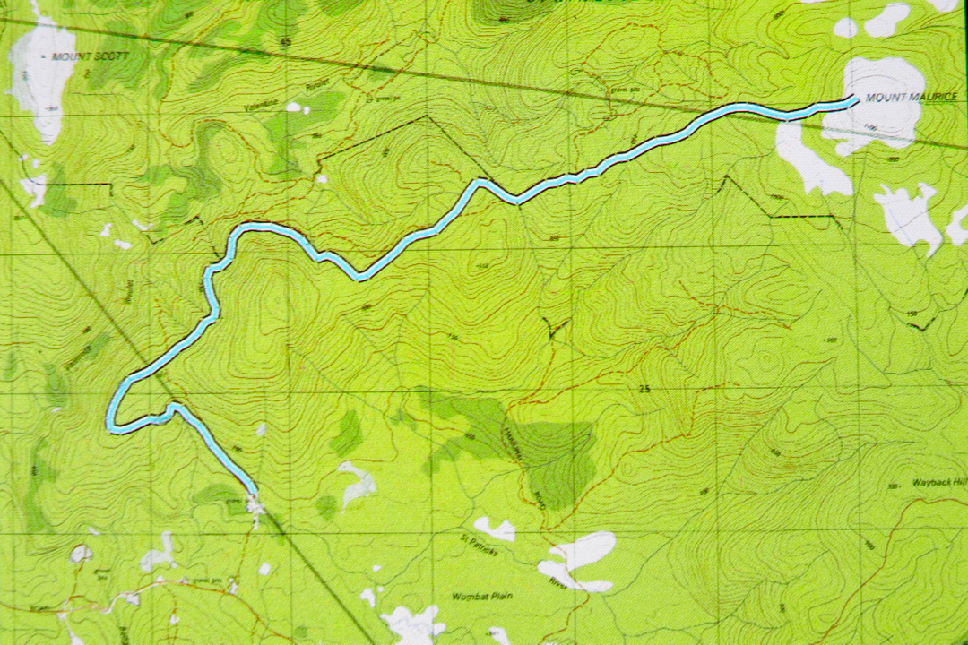
After about 40 mins, I got out my gps to have a check while we walked. This was interesting. We were on a highway that was not on the map, and the road on the map was nowhere to be seen. Hm. (See map/ route below). Better pay careful attention to contours now. They’ve completely changed the forest. Contours roughly in order at this stage, but we were about maybe 400 ms south of where a road should be. I switched map scales, but the next map said the same. Maybe the original drawers of the road had been careless and just stuck in an approximation. Nonetheless, contour-vigilance was required in case this autostrada led to nowhere that I wanted to go.


After 58 minutes (putting this in, in case it is helpful), we came to a post with two reflectors on it. No track corresponded to my gps location, but I decided the contours and general direction were good, so we’d take it. Three minutes more, and we found a sign that said: “Welcome”. We just about roared with laughter. I photographed it in case it was the only nice thing we should find this day. We still hadn’t seen any sign of our mountain. This was a real exercise in faith.

It was so much nicer once we’d left the wide, levelled road. There were now some soft, mossy sections under foot and the myrtle count increased. Birdcalls could be heard for the first time. And we had shade, blissful, soothing shade. Ahhhh. This wonderful section of forest lasted a full twenty five minutes. The trees were huge – tall, wide and stately. Ents watched our progress. Every now and then there were magnificent pink granite tors covered in moss. I delighted in them. The only problems were that we still hadn’t seen a mountain, or even a hint of a mountain, and we also hadn’t found the sort of contours that a mountain has. The map had a little gang of them, huddling together before the summit, and we were just gently easing our way along, only vaguely upwards. Somewhere we needed to encounter and cross contours if we were to climb a mountain.

All too soon our lush green primeval forest ceded to dry sclerophyll shrubbery (after 25 mins), and after another five, we encountered our first scoparia bush. Now we were on a flat, wet patch with not only scoparia but also fallen dry enmeshing bushes that resisted our progress. And there ahead, at last, were a couple of contours and a knob that I guessed was our mountain. Hoorah. Through a short but beautiful section of quite open and tall melaleucas, we hit wind and more scrub, and three minutes after that we were by the trig. I could see that much better views could be had from the other, non-summit end of this dome, so we fought scoparia and wet pools and went over. Yes, great views of all the surrounding mountains, but in particular of Mt Victoria, Albert, Saddleback, Ben Lomond, Barrow and Arthur – and we could see the sea.  We photographed, snacked, and descended. The descent took a couple of minutes longer than the ascent, which roughly translated means I was hungry.

St Patrick’s River crossing is a beautiful spot (and would make for great camping if you’ve come up from the south to bag this peak). It would have been great to have lunch there, but I hadn’t packed any, so drove back to Launceston in time for a late lunch instead.