
I am not someone who enjoys dashing huge distances on a holiday, and thus, on my first trip to Iceland, I only saw the south-eastern corner, and took two weeks doing it. This trip, I opted to see the Snaefellsnes Peninsula, and the coast along the north east. This particular itinerary meant I would be mostly having a huge waterfall bagging spree, with climbing mountains most days for my daily exercise … which makes this trip not much different from the last one.
I wan’t as excited about this trip as I was before the last one, as this time I would be all alone, whereas last time, I shared all the fun and excitement with my daughter, Yelena. However, I’m used to doing stuff alone these days, so I am not sure why this hassled me. I guess because Lenie and I had had such enormous fun last year, I couldn’t help but feel lonely about this year’s prospects. Na ja. Off I set into the blue yonder.
I’m not actually sure what other people do when in Iceland, but I obviously have an impoverished imagination, as I can think of nothing better to do than visit the island’s many fabulous waterfalls. As usual, I spent not a single second in the capital (or any other city). I landed, collected my car, and drove for nearly 2 hours to a tiny farm in the middle of absolutely nowhere, which is just how I like it. My base for the first four days was at Fludir. I had my own little house on a farm.
Day 1, I arrived fresh off the plane from Tasmania, forty long hours of travel behind me, at about 7.30 pm, so the hospitable farmer’s wife gave me enough goodies to see me through until the shops opened the next day. Out my window lay the huge River Hvita. I don’t actually like my rivers quite so enormous, but it was still nice to be near a river. The noises of cows and sheep and blackbirds could be heard on occasion. The trees out the window were just coming into bud. Spring was on its way. The snow was mostly in the process of melting, when it didn’t decide to have a last fling, which it did a few times. Due to snow melt, all waterfalls had massive volume. I hadn’t thought about that when I opted for May. I only thought of choosing “fewer tourists”.
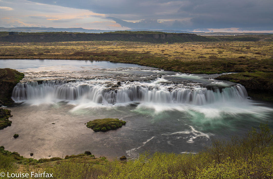
Day 2‘s major fall was the Bruarfoss, easily accessible from my farm. En route, I passed a sign that said Faxafoss (given a different name on my Michelin map for some reason), so pulled in there to spend some time with it. The sky was moody; the day cold. The water was a pleasant colour, and I felt right into the swing of things by the time I continued on to my goal. Googlemaps was guiding me, which was helpful. I merely typed in “Bruarfoss carpark”.
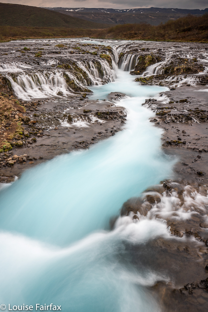
There is a track to these falls which is 3.5 kms in each direction. It is very clear, and mostly follows the river Bruar, which contains not only the object of one’s quest, but also the lesser known – but nearly as magnificent – Midfoss and Hlauptungufoss. It was (ambling upstream, taking everything in) 23 mins to Hlauptungufoss, 12 more to Midfoss, and 15 beyond that (ie, 50 in total) to Bruarfoss. On the rebound, my gear was tucked away and I was faster: 50 mins up, but only 40 back. The blue of this river is spellbinding. It remains one of my favourites.
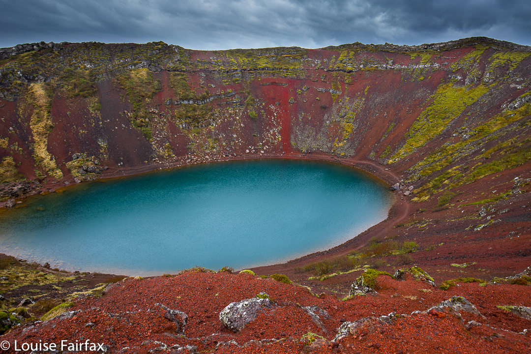
After lunch it was raining, but I decided to see this “thing” called Kerid, which announced itself as a major attraction, and wasn’t far from my intended route to my next waterfall, the rather boring Urridafoss, noted for being the most voluminous waterfall in Iceland, but, as pure volume fails to impress me, this was merely a box ticking exercise – although I photographed it for the records, of course.
Kerid was a pleasant surprise. Due to the now heavy rain, I decided it was just a bit of tourist hype, and was about to go away, when two other travellers came back from having visited. I asked was it worth the cost. The girl sat in my car and showed me her phone photos. I put on my raincoat straight away. What amazing colours! There were even some fun trails to walk. I loved it there.
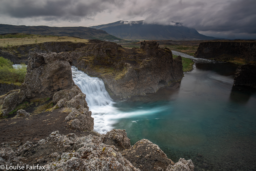
Day 3 was a bit of a mixture of a day, with possibly more failures than successes. I won’t bore you with names, but several of the falls I had planned using the map were either not accessible at this time of year, or were non-events lying on the huge and unimpressive glacial river, the Þjórsá. I have now learned that what I love is “run off” rivers, and the big glacial ones, which tend to be a dull, milky olive green colour and full of sediment, fail to impress. But we are all different, I know others for whom “the bigger the better” is what gives them kicks. And so it was that I drove quite a long way along this monster, not delighting in its offerings, until at last I reached the Hjálparfoss, which is on the Fossa River, just before it merges with the Þjórsá. (How many Fossa Rivers are there actually in this country?? When in doubt, call your river “Fossa”.)
Hjálparfoss was a very pleasant diversion after so much milky mirk. It was the fabulous Iceland blue, with interesting knobs and bobs about the place, so I had fun climbing this and that, partly to get a different vantage point, but probably more because I do love climbing things. Apparently my antics were being watched from below by a trio of Koreans, for we met each other later, at the next waterfall, and they commented on their spectator sport at Hjálparfoss.
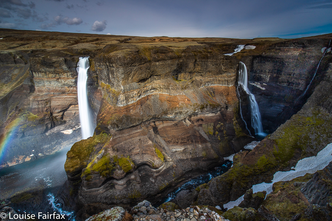
Content, I headed of for Haifoss and Granni. Luckily my googlemaps was cooperating, as there were no signs to these falls on the main road 32. The paper map said I needed rd 332, which is cute, as it wasn’t named either. Anyway, Siri spoke to me, so all was well, and I bounced along the gravel, happy that I’d decided to pay for comprehensive insurance. This road was, for me, pretty scary, and I drove like a snail, not wanting to ding the car (despite the insurance). My Subaru would have waltzed in , but this Hyundai was very low slung, and made me nervous. An unnerving number of stones mercilessly whacked its underbelly.
With enormous relief I parked at last, prepared for what I had been told was a three hour hike. Alas, the falls were about two hundred metres from the car. The challenge, yet again, was in the driving, and not in any physical exertion. I had fun meeting the Korean guys here. They were much braver drivers than I was.
On way back, I had intended to then visit Gjarfoss at Gjain (signed), but the road looked muddy and a sign indicated they wouldn’t rescue you if you got stuck, and I got too scared to go, so gave it a miss. Sadly. The photos others have taken look appealing.
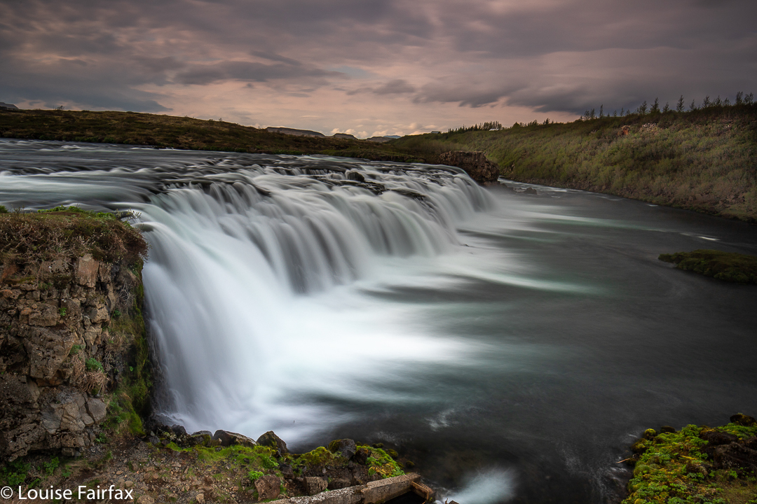
That was the first of many waterfalls I was locked out of that afternoon. I did an enormous amount of driving, but was pulled up short each time. By now the wind had worked up a temper, and I was less sorry about not being able to hike or see any falls than I might have been. Pjofafoss, which I did get to see on the way back after all this failure, was lovely, even if the mountain behind it, normally providing the perfect backdrop, was not visible due to heavy, low clouds. Not only had I failed on many waterfalls this day, but my exercise tally was a dismal twenty minutes. Not my favourite day in Iceland.
I thought I was by now (Day 4) due for a pretty pink sunrise or sunset, but the rain continued.
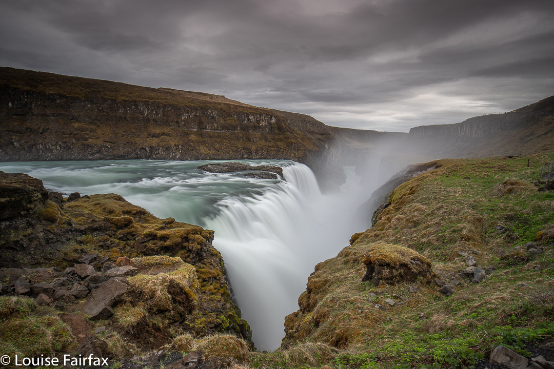
My first stop for the day was the famous Gullfoss. It looks as if it is normally pretty touristy, but I shared it with only two others. It felt like it was about minus ten, and I was a bit miserable. The solution was to go into the shop (lucky it was touristy and had one), and to buy a pair of windproof, waterproof gloves and a sturdy yellow coat. Now I was set to enjoy myself, and went back to the falls. I could not have tolerated them or anything much else if I hadn’t done that. If you’re going to throw yourself at Iceland, you need to wear the right gear.
And now I could give myself over to the power and might of this place. The volume of water was absolutely mesmerising.
Thingvellir was a huge disappointment. The idea of what it was thrilled me, but you weren’t allowed to go anywhere, or do or anything. You had to stick to a highway indicating that just out of sight was something lovely, but you may not have a look, in case someone with an IQ of 20 does some damage. Beauty was always a step or two away, if you wanted to get the proper angle. They teased and tantalised us, but never delivered. My ‘hike’ was a non event. There is no hiking in this park. And no real maps, and no information on what you can do (basically, nothing, other than a couple of granny strolls). What they should do is cull the numbers by making the path small, uneven and difficult. Instead, they’ve simplified, widened, smoothed and evened it all so they can attract millions of people who have turned up in busses and don’t seem remotely interested in what they’re looking at. They’re busy consuming food, the wrappers of which they throw on the ground as they go. I looked over the edge at one stage, and I have never in my entire life seen so many cigarette butts. These had company in the form of paper cups, tissues, and wrappings. That’s what happens when you go fishing for tourists at any price. How I would have loved to walk on a little path between those incredibly important tectonic plates and seen them in nature rather than with a road through the middle. I expected heaps of this park and got almost nothing back. My best photos were from outside it.
Just in case you don’t happen to know what this park is actually about, it has enormous interest if your inclination is for history, or for geology. Historically, if you have done any reading of the sagas or of Icelandic history in general (and I had read up big time before my previous visit), this is the spot where the annual kind of parliament met, in the amphitheatre where you can stand. Lots of incredibly important matters pertaining to Icelandic history were decided in this very spot – like the decision to change from worshiping gods to becoming a Christian nation (in order, mainly, to stop Norway from attacking). This mammoth decision was made around 1000 AD. The sagas changed their tune a bit after that.
Interesting as all that is, for me the most fascinating aspect, however, is the geology. The Þingvellir NP is located in a rift valley created by the drifting apart of the North American and Eurasian tectonic plates. Is that not totally amazing? This drift of the tectonic plates is not exactly at the speed of summer lightning, so you are not going to do the splits if you put one foot each side: they are travelling in opposite directions at the rate of about 2cm per year. As they move apart like this, they cause the land between them to subside, and that is what is in the park. But they want to steer all tourists into one spot, so it is tricky to get a good look at what you’ve gone to see. In some of the gaps created by the rift, water has seeped in, and it is as clear as could possibly be, and also is, of course, that fabulous deep blue of Iceland. Whilst being very annoyed, I was also in love, so returned the next day very early so I could have the park to myself, and have a better explore.
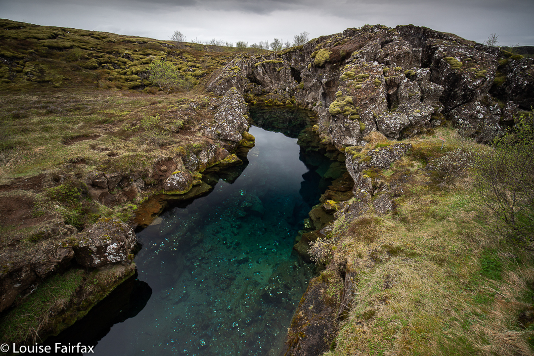
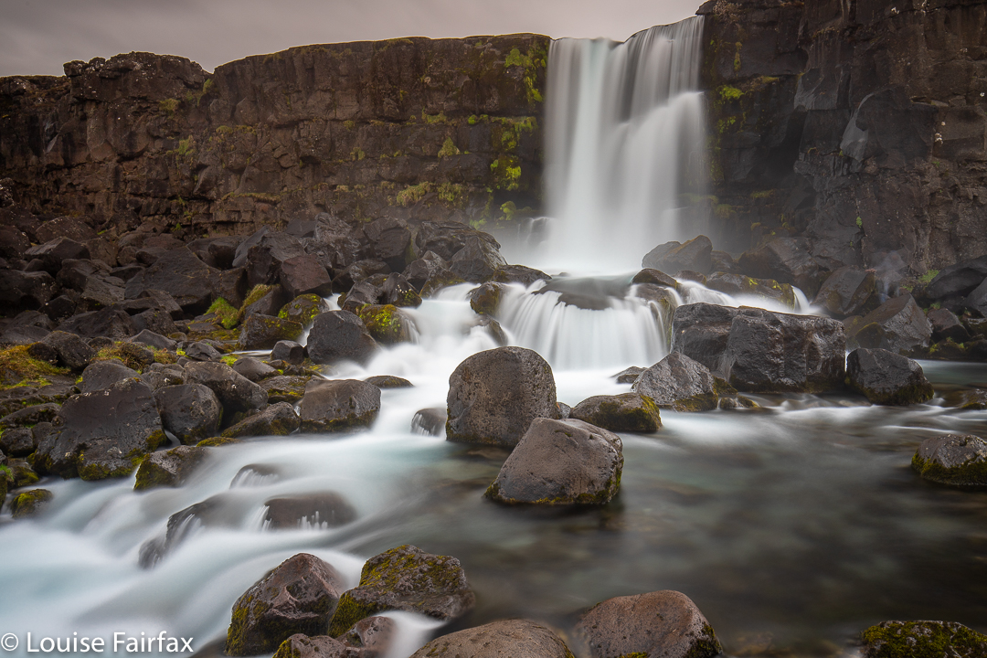
The Almannagjá gorge path goes between the edge of the North-American plate and an old part of the wall that collapsed. Most tourists mistakenly think this is the corridor between the two continents. The gorge basically ends at Öxaráfoss, which used to look quite beautiful before they built the viewing platform. The beautiful ravines made by the tectonic movement have filled with the Langjökull glacier’s water, which has travelled underground for decades through porous lava rock, undergoing a very thorough filtration process. When it enters the ravines, the water is pristinely clean and crystal clear. This is nice. People are allowed to pay to go scuba diving there, but photographers are not allowed to get an angle on any of the ravines that demonstrates this beauty of colour. I did not go scuba diving.
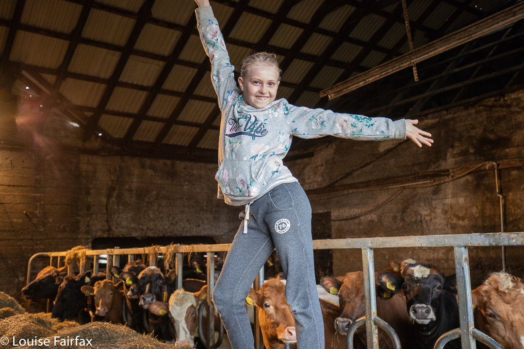
This night, my fourth on the farm, was my final night at this location. The next day I would proceed to Borganes, further west. (Seriously, there was some logic to my route). That late afternoon, the children of the farm knocked on my door. They wanted to show me the newborn calves and lambs and to generally chat to me. They were 8, 10 and 13, and spoke excellent English. Quite apart from having fun seeing newborns and being-borns, and smiling at the children’s exuberance and their pride in their farm, one of my happiest memories was of us all walking down the muddy road, singing Abba songs together. I didn’t tell them that I have lived on a pseudo farm for most of my long married life, and have annually had my own newborns.