Hyperion 2016 Mar

Mt Hyperion March Long Weekend 2016

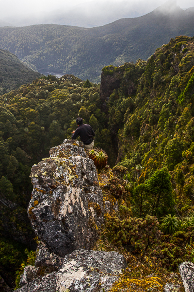
What is it about a mountain like Hyperion that demands our respect and makes it impossible for us to take it for granted? Sometimes it’s the shape, sharp and steep, where no easy way seems possible from afar. Other times, it may be the stories we are told of it, or warnings we are given. I had received plenty of these with regard to Hyperion: “Don’t do that one solo, Louise”; “Don’t climb it in mist. You want to be able to clearly see the dangerous drop-offs”; “It’s very airy up there”; “Hm. You and Angela are very short, I’m not sure you can do it. Maybe if you help each other you can”. Some people give a slight (very reassuring for me, the listener) shudder when they recall the exposure. I was certainly not going to take this one lightly.

It is now cool enough for fungi. Yippee. 

If you want to see quaint, tasteful bridges like this in the Lake St Clair area, you’d better hurry. Pukes and Wildspite are ripping them out and replacing them with monsters made of synthetic material, a metre or more wide and giant handrails, of course, because if we fell into the water we might get our tootsies wet and sue them. I weep for the loss of the rustic, picturesque and natural. They are even thinking of replacing darling Pine Valley Hut with something bigger – perhaps something as utterly unsuitable, chilling and unwelcoming as the Bert Nichols Hut. Who knows? If they think it will get more tourist dollars, that’s what they’ll do.

I set out a little in awe of what might be my fate on this mountain of the stories and warnings, and rather anxious. Rock chutes, and reaches that are challenging do not scare me, but the possibility of toppling to my death from a ledge in a moment of carelessness does, and not just because of the recent accident of Feder. Ledges bother me. Could I summit this mountain? I don’t usually doubt my ability to get to the top, but with Hyperion, I was unsure, AND I certainly did not welcome the last-minute change in the weather forecast that now promised us rain and mist every day of our possible attempt.

En route. I have dubbed these “Geryon Base Camp Falls”

The first day was so wet and gloomy that we, a group from NWWC plus the Fairfaxes, stopped short at Pine Valley Hut, thus allowing us to keep our tents dry (and lighter) for a bit longer before the climb. Any excuse to spend time in this valley is a good one, and Bruce (my husband, still with us at this stage) and I enjoyed wandering and photographing in the light drizzle of the afternoon.

Russula sp coloured the forest

Next day, we climbed in mist and rain, up through glorious forest and onto the Du Cane Range, ultimately descending to Lake Helios for our campsite, pitching our tents shortly after 3pm. We all expressed astonishment and pleasure while we set up camp at the brief appearance of the sun. Our leader, Greg, announced that if we were to make a summit attempt, as soon as our tents were up was probably the best moment, as we did not know what the morrow would bring. This was a great call. The next day, we now know in hindsight, would not have been suitable.

Climbing to our base camp at Lake Helios.

The group gains height on the Du Cane Range

The beautiful Lake Helios, perched under Hyperion, our goal.

I didn’t find any particular moment of the climb itself (the manoeuvres involved) to be scary. What concerned me was the weather, which closed in and fogged us up so that good routes up the next stage were harder to sight. I feared the unknown that lay ahead, and I was anxious about the time, as it was getting later than I liked should we have trouble getting back down. I think we all probably harboured our own little anxieties as we forged on upwards, hoping it would work.

The final stage lies ahead. We can get there.
Six happy summiters. The group minus me. I was too cold, and in too much of a hurry, to use auto timer and find a rock to balance my camera on.

When anticipating summitting Hyperion, I always thought I would be joyous and whoop with delight when I reached the top. In fact, all I did was heave a sigh of relief, grab a few photos in the icy wind, and clear out of there, back down to safety. Tempered joy would come later. Relief is still the dominant emotion.

Clouds await us below.
An aspect of the ascent that interested me was that I was hit by (another) falling rock, this time on the thumb. I have always thought that if this happened, I would lift my hand in pain, lose my grip and possibly fall from my position. I am delighted to report that the worst that happened was pain and that I did not let go. This is quite a comforting thing to know. I had to keep moving so the pain didn’t overwhelm me, and the others understood. Movement took my thoughts away from my thumb onto things I could control, like making the next climbing step. I was fine for now.
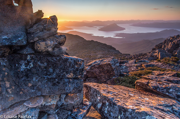
Sunrise next day. I hope you like this shot. I had nearly as much hand pain taking this as I had from the falling rock. Temperatures were sub-zero while I took this tripod long exposure with no gloves on.
The next morning, it was so cold we had to wipe sheets of ice from the tents. Rocks were slippery. Climbing Hyperion would have been treacherous.

We exited through the Labyrinth, making an attractive circuit, and descended to my husband, who had climbed the Acropolis while we were away.

Mt Ossa and Pelion East from the northern end of the lake shortly after dawn.

Othrys 2016 Mar

Mt Othrys Mar 2016

Leeawuleena spread out before us
Mt Othrys has one of my favourite summits. Leeawuleena (Isn’t that the prettiest name imaginable? It is the Aboriginal moniker for what white people labelled Lake St Clair, and means Sleeping Water) sparkles below, and the broken dolerite pillars jut and thrust their way in odd but attractive directions, making for a jagged and interesting framing of the scene and a dragon-spine skyline.


Blue and green should always be seen

I could have spent an hour up there, or more, but will have to do that next time. On this occasion, we were in a hurry. Angela had been on call, so we could only begin our exploits at 11 a.m., and she needed us to keep to the book’s estimated 7 hours for the climb. That sounds like plenty of time for a 25 km equivalent exercise, and it was – just – but only by keeping up a pretty smart pace throughout the day, and allocating a mere 25 minutes for lunch and photographs at the top, for, you see, this beauty is rather inhospitable to visitors, and the mountain has grown a rather nasty patch of protection to prevent all but the most handsome of princes from entering. We are neither handsome nor princes, but did manage to find a way through. Othrys has a bad reputation amongst bush gossipers, and for quite a good reason.

We lost a bit of time on the way there trying to find the track amongst the button grass plains, but as we figured this was faster than making our own way, persisted in searching for it. We left the pad at a rock with a cairn on top, which fell a bit short of my intended point where the summit-to-path projected line intersected perpendicularly with the path. To put us back on the route I wanted, we headed for a waypoint I had made on this imaginary line, and found an excellent route through the melaleuca scrub hugging the creek at this point. Our route through the forest for at least half the journey was also relatively easy, much better than reputation has it. However, in the upper reaches we struck a band of young, dense melaleucas that left me exhausted by the time they’d finished their sport with me, but we did win through, and from that point, headed straight up rocks for the summit, which was reached without much difficulty.


Different view of Olympus

On the descent, we were able to stay on the rocky nose for longer, it now being visible from above, and had a trip down that was an hour faster than the ascent of four hours.


Summit dragon spine

Unfortunately I cannot give you my normal jpeg version of the screen image of our route, as about 200ms from the top I checked the gps to see how we were going, and undid “screen lock” and then bumped something (I know not what), with the result that my machine stopped recording, not only for the route up, but also refused to cooperate on the way down. It wouldn’t even show me my gps position. This morning it seems in better health, so I have no idea what I did, but there is no track for the remainder of our climb, or for our good descent route, alas.

Should this interest you: The mountain offers a fascinating angle on Mt Olympus and the shapely Mt Ida is directly opposite. In the distance lie many other mountain friends from this much-loved region, while directly below to the other side, the Cuvier Valley spreads out for display, with Lake Petrarch adding more blue sparkle to the scene. Particularly interesting for Angela and me, as we had climbed there only a week before, was a new perspective on Hugel and Little Hugel, with the Cheyne Range clearly visible behind. So many loved places visible at once; it was grand.

Geikie 2016 Mar

Getting near sunset at our camp spot, day 1

Mt Geikie at last.
If you would like a little shot of adrenalin, then borrow someone who’s had Parkinson’s Disease for fourteen years, and take him up Mt Geikie alone on a misty day on which the way is a point at the end of a compass needle and the route, an uncertain traipse through small and large cliffs and patches of scrub. The mist was so thick at times that the mountain was not even a dark shape in the gloom. It just wasn’t there. And if you’d like a bigger dose, then take said gent through the thick band of tanglefoot (Nothofagus gunnii) and scoparia that runs from The Bastion, due west.

Sunset approaches. The light was eerie – and beautiful

The watery sunset arrives (long exposure)
Last time I attempted to take my husband up this mountain, we got as far as The Bastion, but in the thick mist and with darkness rapidly approaching, I pulled the plug. We had already exceeded my predetermined turnaround time, and I could see no ready way of getting down to the saddle that lay between where we were and our goal. There was no time to search, and certainly no time to try and fail. The mist was ominously dark. I do not regret what I still see as a wise move that day (you can read about it on:
http://natureloverswalks.blogspot.com.au/2014/11/mt-tyndall-and-bastion-89th-nov-2014.html), but Geikie still remained, so here we were, having another go … on a similar day, but with more time up our sleeves to play with. Although we set out after breakfast, I packed my head torch, so pessimistic was I after last time. Don’t be fooled by my photos: they were taken in brief interludes of visibility. The theme for the day was thick mist.

 Day 2. Off we set across a water filled landscape to our goal
Rocks and tarns: what a great combination

As we had all day to do this, I took us on a scenic Tour des Lacs, ever working our way south. It was glorious. However, even with this stalling tactic, we eventually neared The Bastion – the blockade from last time. I decided to be super-smart and outwit this recalcitrant mountain, and not go near the “summit” that had turned us around, but save my husband a climb by traversing directly to the saddle on contour. Smart, eh? Trouble is, the map doesn’t tell you that the band of green oozing out of The Bastion to the west is a very nasty brand of dark green. It is also lavishly replete with boulders about four metres high with vertical walls and no cracks to get a hold. I lost count of the number of culs-de-sac we landed in. Each time, we had to back out and try again elsewhere, yet elsewhere presented us with an impenetrable wall of bush or more rock. By climbing on top of scoparia bushes – wondering if they would snap and dump us two or three metres below in a pile of prickles and tangles from which we could not be extricated – or doing likewise over the tanglefoot (both treacherously slippery when wet), we managed to inch our way southwards. I was stunned that Bruce managed to keep progressing. I was trying to choose a Bruceable route, but there was not much on offer.


Here a tarn, there a tarn, everywhere a tarn, tarn
When we finally burst out into ground you could walk on, it was a moment of great joy. The actual climb of the mountain was a snack and quickly dispensed with. It took my husband only twenty minutes up, thirteen down to do the bit we’d come for, once he could begin.
Out into the clear, hooray
And we even get to see our mountain for a second or two before she runs away and hides again

If you assume you’re going to bag a summit with no problems, there is only moderate joy in the dubious accomplishment. You have invested only a little emotional energy in the exercise. Taking Bruce to Geikie, however, nothing was taken for granted, and so we both felt elation sitting up there under that trig. Bruce had done the unexpected (I had thought he’d choose to read a book at camp while I summitted solo), and we were alive to the momentous nature of what he had just done.

Once on top, the clouds did part for long enough for us to get a partial glimpse of our surroundings.

Our best view. We found it quite exciting

On the return, we did not opt to save contours, but headed straight for The Bastion, skirting only the initial rampart by hugging (literally) the cliffs to the east, eventually going up a chute to the top. I enjoyed this route, but Bruce found it tested his vertigo. This was 45 minutes faster than the outward journey! The rest was Sound of Music walking over glorious alpine gardens, decorated with pink rocky stripes and more fabulous tarns. It had been a day of great (landscape) drama and subtle beauty. As we sat back in camp eating our lunch, the sun came out. We leant back and basked in its warmth, in no hurry to pack up and leave.

Me on The Bastion on the way back, taking a peak over the edge at the cliffs we’d been hugging

I made sure the trip back was filled with water too 🙂

We had approached the Tyndalls via the north (Burnie), so I decided to leave via the south, so drove to Queenstown, and then east along the beautiful Lyell Highway to Derwent Bridge, waving hello to my many mountain friends as I went. I have on many occasions spoken about delicious meals had here at the end of expeditions. It was time to let Bruce have this fun too. He was not disappointed. Sated and satisfied, I had to blast us both with opera and sing at the top of my voice the whole way home to prevent falling asleep at the wheel. I am dangerous on a full stomach.

Maps will be added by Thursday


Horizontal Hill 2016 Feb

Horizontal Hill 8 Feb 2016

Angela on top of Horizontal Hill, the Guardians behind
Our friend, Mark, first mooted the idea of climbing Horizontal Hill in the dead of last winter, when the nights were frozen and the days icy. I wanted to climb this too, but had decided reservations, for the route involves a 350ms wade through Lake Marion before you begin ascending. I thought about wearing my wetsuit, and meanwhile bought a pair of light, padded Wellingtons. I was not looking forward to the ordeal, but, as Malcolm Fraser said, “Life wasn’t meant to be easy”, and well, you take what comes in this business of trying to climb all the Abels.

Moody sunrise at Lake Marion
Luckily, on the appointed day, it was snowing, as well as icy and freezing, and we climbed Mt Hobhouse instead. We waited for the next opportunity, but other mountains pushed the queue for one reason or another, until last weekend, when I noticed that, with a little rearrangement of several programmes, our old intrepid trio could climb this together before returning to our separate agendas. Now hyperthermia and dehydration could replace hypothermia – a much more comfortable way to damage your body.
Now, the dreaded icy lake was a delightful warm bath. Padded Wellingtons were replaced by open crocs and the wetsuit allowed to continue gathering dust in the laundry. The wade was fun, even if I did keep sinking, and then we left the water behind to head upwards on bearing through rather lovely pandani forest, travelling towards the head of a pointy spur. Punishment for the unexpected ease here was the inevitable band of scoparia, but I have seen a lot worse and we swallowed our medicine, and in under two hours were doing the last climb up a sandstone cliff to the summit area, to at last sit up there and eat and drink in both view and water.

Our route up Horizontal Hill
Next morning, after a relaxed beach breakfast, Angela and I set off for our next goals, vi.z, Falling Mountain and Castle Crag.
http://www.natureloverswalks.com/castle-crag-falling-mountain/
It was actually too hot to climb them that afternoon, so we got ourselves into position for an early assault in the coolness of the next morning. It was good we didn’t go up that afternoon, as Angela was not feeling at all well, and the next day she found a tick on her body that we assume was the cause of the malaise.

Pandani Shelf and Eves Peak 2016 Jan

Pandani Shelf and Eves Peak to begin the New Year 2016

“Ah this is the life”, I said with meaning as I gazed around at our tents pitched amongst King Billy Pines and Pandanis, with swathes of pineapple grass nearby, burgeoning lumps of lurid green cushion plants, a creek of superbly clear water maybe 50 metres away, and Mts Anne and Lot clearly visible, brooding darkly above. Light accentuated the claret edges of the curling green pandani leaves.


The Wilderness offers many different things to different people, as well as a range of various pleasures to a single person, depending on his / her current mood or needs. It can be a quiet place for reflection or meditation; a place where you can submerge yourself in the almost overwhelming beauty of a vista or detailed minutiae. Or it can be the venue for an adventure – solo or with friends. Some use it as a sporting arena in which they can pit themselves against the challenges of nature, or as the most beautiful workout place imaginable. Many harbour it as an escape from the stresses of work or of modern life in general (it should not surprise you to learn that bushwalking was very popular in the Great Depression of the 1930s; walkers went bush, where the woes of debt and unemployment could easily be forgotten for the time they were there). For many of us, it is a place where our soul finds peace.

 Wilderness means all of those things on different occasions to me, and there are thus times like last weekend when I go there, not to climb a new peak or have a grand workout in nature, but just to be there, pure and simple: to sit back and stare at the wonder of it all. What better place for that than a circuit that encompasses Eliza Plateau and Pandani Shelf? (Many other places, of course, equal this venue for the purposes).


Here, roughly, is our rather meagre itinerary:

Day 1: Drive down from Launie, avoiding (with enormous self-restraint on my part) the temptation to eat cake at The Possum Shed en route. Even so, we started so late I was already desperate for lunch before my pack was on my back. I was promised l could dine at the cute little hut at High Camp, which seemed like a very late lunch to me. Going was much slower than expected, as, not only was the day exceptionally hot (33 in Launie), but one of our party (who claims he didn’t overindulge on New Year’s Eve) was rather ill, and looked the colour of a garish IG sunset after a mere ten minutes. Our schedule became akin to “walk fifteen, stop thirty”. No matter. The view on the ridge was lovely despite the general haze of the day and we had all day to go almost nowhere. We switched from Plan A, which was to camp on Pandani Shelf, to a new plan to sleep the first night on Eliza Shelf. We camped with a massive view, tarns to drink from, and a mountain for me to climb for sunset (Eves Peak).

Day 2 was even shorter. We went from this spot to the Anne / Eve saddle, and then circled Anne on the non-walkers’ route side (i.e., to the west). Most climbed Anne from here, before the whole group continued on to the shelf, which we briefly explored before setting up camp. I was not feeling at all well myself this day, so once my tent was up, just sat around enjoying the mood of the place and chatting to the others. It is such a treat to have the leisure to do precisely that and take some time out from always being underway, much as I love movement and summiting new peaks. Mountains offer me healing to refresh me for my role of being my husband’s carer. I was so enjoying this existential pleasure I didn’t even bother going off looking for photographic opportunities.

Day 3: On this day, we exited the shelf, walking along the fabulous ridge on which it lies for a while to near where a most dramatic sinkhole can be seen far below. From the small group of King Billy Pines before the hole (biggish cairn), we then dropped steeply off the edge, following an assortment of tags in the rather enthusiastically marked pad through King Billy forest up high, and later, rainforest (lots of wonderful Myrtles) to the button grass plains below. From there it was a trudge along a pad as wide as a pinelog plank on mostly dry mud – although one of our small party of six went in up to her thighs in the goo. After the shade of the forest, the button grass with stunted, face-high melaleucas to be pushed out of the road nearly every step felt glary and relentlessly hot, but the medicine did not take too long to swallow. Unexpectedly, we popped out onto the road. In less than a minute a car appeared, travelling in the wrong direction, but I managed to uphold my unblemished record of success in these matters, and procured us a lift with the very nice driver who agreed to turn around and go backwards for 10km to take two of our party back to get the vehicles.

We made it to the Possum Shed before it closed and so had a wonderful time sharing cake and coffee at table together beside the river before continuing our drive home. (No, they do not sponsor me. I say this simply because I love home-cooked food and quality caffeine).

 Rolfe photographing the sinkhole.