Lots Wife 2016 Apr

Lots Wife  Apr 2016

Sunrise day 2. Mt Sarah Jane in the background
Weee; an expedition to climb Lots Wife. Happy to have my pack on my back and to be off bushwalking again, I played dodgem in the mud-swamp bogs that surround the Lake Judd area, weaving to avoid the more treacherous, neck-deep holes and swinging like an orangutang at times from one melaleuca sapling to the next in an attempt to avoid death by mud suffocation. Not only do I find this to be an unpreferred way to die, but also I have my precious camera strapped to my chest, so also fear a mere face plant.

Andrew, huddled, admiring the gold

It did not rain, but all three of us were pretty wet by the time we breasted the ridge that forms the springboard for Mt Sarah Jane, so that the 80 km/hr winds that greeted us chilled us to the bone. We had rather been hoping to burst into balmy, warming, drying sunshine. The wind was a rude and unexpected shock.

Down they drop

We had all planned to camp here: the other two to avoid carrying the packs back up the slope the next day, and me because I wanted to sleep close to the magic panorama on all sides that this spot offers. It was a deal, despite the wind, so we searched around for a moderately protected niche. So much for my desire to have an expansive and photogenic vista out the tent window: there was no sunset that night. No views regaled us. Mist encinctured us. Two of us were so cold we elected to go straight to bed without even having any dinner. I was far too cold to cook, and just wanted to be snug in my bag. I was in my bag, but not snug. The wind blasted a fury all night, but died down somewhat by dawn, when the world filled with golden, misty light, and the full moon still pierced a hole in it to the west.

We set out at around 8: late enough for the sun to have cleared the mist, but early enough for us to enjoy the crisp, early light in the mountains. Along we went with vast views to left and right, then down to Spanner Lake, and then up, up, up through glorious rainforest until we reached the ridgeline that leads to Lots Wife. Getting close now.

Approaching Lots Wife – stone, not salt. Might be easier to climb.
I am told that a friend, not at all given to swearing of any kind, when greeted with the sight of Lots Wife that confronts you when you pop out of the forest and onto the ridge, said: “Oh shit”. These words pretty adequately describe my own feelings. I walked along, gazing at this monstrosity, wondering how we were going to find a way up. The face does not have a notice out saying “Welcome stranger”. The fact that that very morning we had met a young guy returning from a failed attempt did not fill my heart with hope. Lucky I was not just here for the summit. I was having a ball and the views were fantastic, and maybe that was all I was going to get out of this trip (plus some sunrise photos already in the bag).

Summit view from Lots Wife
We followed the pad along, further admiring the surrounding cliffs and peaks, but concentrating on our tower, wondering if we’d get to look back at it on the rebound with a successful feeling, or whether we, too, would be defeated by this giant. The pad led to a chute that did not look promising, but we gave it a bit of a go, Andrew leading, before deciding it was too dangerous. Pete remembered a conversation with a club member in which he’d been told to go past the obvious-looking chute and drop down a bit, proceed further and then choose the next chute, a scrubby one. This we did. This chute, too, had its challenges, especially the way I took it, going around a buttress, hanging for dear life by fingertips and toes to the narrowest of ledges (4 cms) with a shocking feeling of space (not looked at, but all too easily felt) below me. Pete, following behind, cleverly spotted a route over the top that was much safer (and used by me, too, on the return).


Another summit view from Lots Wife

It was a superb feeling to burst out of the cavernous chimney onto the giddy heights and see the summit cairn, problem free, just ahead. We sat there for an hour, eating and enjoying the scene before beginning our rather reluctant way down. It was such a privilege to be in the presence of a view like that, and as if victory and the view were not enough, nature gave us a pair of wedgetailed eagles circling quite close to us overhead, riding the thermals, as a bonus.

The close of day from our camp spot
Looking towards Lake Pedder

I felt deeply satisfied as we descended through the lush rainforest, each musing over the joy of a climb like this. I was hungry back at camp, and wanted to enjoy dinner in the light and the open, and to concentrate on photography at sunset, so cooked tea at 4.30 (I have never eaten that early before), enjoying the last of the day’s warmth before I froze my hands off shooting the golden rays of the western sun as it sank behind the mountains surrounding Lake Pedder.

On the way home, we made up for lost calories with burgers and cake (and more) at the fabulous Possum Shed, toasting our success with coffee.

And Alpenglow to the east

Claude 2016 Apr

Mt Claude Apr 2016.

The view to the left before you leave the track to embark on the rocky climb
In terms of having intricate directions in the final stage of the climb, Mt Claude is one of the trickier mountains, so instead of my usual sort of entry, I am going to try to provide extra details in words and pictures to augment the already excellent instructions we had from www.bushwalk.com, the bushwalking forum. Despite their helpfulness, we did have two “detours” where we managed to stray, so hopefully the pictures and text below will help others who want to use this much safer route of climbing Mt Claude. I came across it last week and thought it looked fun. Angela agreed, so off we set.
Follow the main path (that begins on Olivers Road at the Lookout, and that, after you leave it, continues on the northern side of Claude, heading for Van Dyke) for about three kilometres, turning right and slightly down (ESE) where an arrow tells you to, rather than heading for the tower. We had a diversion to the tower due to not quite understanding the instructions. I’m not sad that I had the extra climb. It was quite interesting, but the excursion gave us a huge warning about how very slippery the conglomerate was today. I had already felt how greasy the rock was, but still got a horrid shock when I saw Angela’s foot come unexpectedly away from her in the descent back to the track, and she began gathering momentum as she fell. I watched in horror as her first attempt to grab something to arrest her fall failed. Luckily the second obstacle worked as I did not like the speed with which she was dropping. Of course, all this occupied maybe a single second, but it felt like an eternity as audience.
Back on the track we went to the south of the tower clump, and along to the flat saddle before the actual summit block. Below is a picture of where, in that saddle, you leave the path that continues more NE to drop down below the northern side of the impressive summit boulders. This little pad here goes to a slot that you climb up. There’s a cairn at the top, and the cairns were generally close enough to follow.

This is the pad you follow to exit the main track
Below you can see Angela climbing a slope, because I called her up. However once we were both up and consulted the notes from bushwalk.com she’d copied into her phone, we saw that we weren’t supposed to be lured by this steep, narrow path, so went back down. It was quite a nice little climb – not slippery like the rest of the day. However, if you get this view, you know you’re wrong.

Along and up we went, consulting the forum notes quite heavily now. They warned us not to proceed along the likely looking trail, pictured below, tempting as it is.

 Instead, the notes say, head for the sky, so that is what you can see Angela doing in this next image.
The notes then say that on the right, just a bit below where Angela is in the picture above, there is a turning to the right. Take it, and it leads to the entrance of the infamous cave. We were both a little apprehensive about how this rope section was going to be in such slippery conditions. Angela was worried about her knee that she’d hurt in the fall, and I wondered if my upper body could drag me up, if that was required, as I had had an operation the previous week and even running still hurts a bit, so my torso’s strength is compromised. Oh well, there was one way to find out.

When we looked into the cave, it was dark and foreboding. At first our eyes couldn’t make out anything at all, but gradually the rope that we’d been promised could be discerned. I could see that it had knots and loops in it, so that would help. The entrance was very narrow, and we didn’t have a clue what lay ahead, so both decided to leave our packs behind – a very sad decision, as that meant no camera, and no food on top. The entrance was so narrow that we wondered, not for the first time that day, how large people managed to use this route. I took the rope, put one foot in the loop, and set out, feeling in the dark for the next loop. It was too much trouble to get my foot in, and my upper body was coping, so I used my knees against the rocks – they had better traction than my boots – and hauled myself up. The series of knots gave good grabbing points, and my knees found indentations in the rock that held me. It worked, although that method hurt Angela’s injured joint. Once up, the summit was very close, and we happily touched it. Thick mist was now rolling in, rising to engulf us. We wanted to see to try to find our way down this slippery dip of a mountain, so set out pretty quickly. I was starting to feel nauseous with anxiety at choosing a route blind. I also didn’t know how it would be lowering ourselves on the rope when the rock offered absolutely no grip at all. It was a long way to fall. However, on the descent, I found I could decelerate by leaning my back into the wall above, creating a bit of pressure to combat gravity.

Hoorah, soon we were down and gathering packs again (Angela is buttoning hers up in the picture above). I wanted to get below the rock section before stopping for our snack so as to ensure visibility. It was with enormous relief that we sat with the view below, still rocky enough for beauty, but by this stage, all the potentially tricky route finding had been accomplished, and, although we were cold, we made time to eat. I needed to eat to relax more than to fill my stomach, I think.

Snack view, down low and out of danger of further falls
In front you see the pad that we followed to do the climb. Angela is standing at the pad-path intersection waiting for her friend who is now taking rather a lot of photos.

Goodbye pretty boulders. They really are wonderful if you’re not climbing up them when they’re moist.  Down we climbed, both looking forward to the food we were anticipating at the Raspberry Farm, which is fast becoming a traditional calorie replacement station.

I’m not happy with the clarity of this. I’ll add a map of just the last section in the morning. Hopefully that will give better detail.

Wild Dog Tier 2016 Apr

Wild Dog Tier 2016 Apr

An early view of my mountain after I had climbed the first swag of contours and emerged out of the forested slopes.
I have never heard or read anything about Wild Dog Tier that has made me itching to turn up at the start line (other than the fact that maybe I could take my own wild dog with me, but she is too portly to get up even this mountain). I have always pictured a dull canvas-green landscape with equally dull taupe scree, and that’s essentially what I got. There are few dramatic points on the horizon, although Quamby Bluff made my life pleasant on the homeward journey, and every now and then I could see well-delineated cliffs to the west for a bit of spice. I had been hoping great things of Sales Lake by way of redemption from this expected monotony, but it failed to deliver.
Summit cairn

 So why on earth summit a mountain that has so little to offer? Because I am a completer of things I have started (my dinner, bad books, almost anything). I have started this Abel List (which contains mountains), so I am in its thrall; it is a Pied Piper calling me to finish what I have begun. In addition to this mindless slavery to a list is the fact that I believe in variety. I don’t eat my favourite meal every night, or only stare at my very favourite photos, or keep reading my favourite book ad infinitum. I risk experiences that will not match up to the best, and, if nothing else, this enhances the merits of things I love most by comparison – and it makes my life richer. And I love expending my energy – even on Wild Dog Tier. It was a fun workout in a different place.
In case you haven’t done it yet, please don’t let me put you off. It wasn’t bad in any way; it just wasn’t exciting or special.

Possibly the prettiest moment of the trip, after I had descended to the plateau surrounding the lake.

 My experience was greatly enhanced by Tortoise’s recommendation to go via Sales Lake rather than the normal route. This meant I got in some extra height gain over the normal route (which pleases me) and much of this was through quite nice, albeit a little dried out, myrtle forest. I had ascended from the car up onto the plateau and reached the lake in just over forty minutes. The mountain was now visible, and didn’t seem all that far away, but the ground was soft, so I knew it would take longer than expected. Indeed, this next section took 1 hr 12, still placing me on top in under two hours.
The way down was a bit faster, which meant I was back home in Launceston for a late lunch. I even baked an apricot tart for desert to help replace calories.

The most “exciting” part of the trip, if one needs this to be satisfied, was negotiating the hole in the road mentioned by my helpful advisor. She had said it was marked with a taped stick, so I saw it coming and got out to inspect it before I drove past, as her description had been accompanied by faces suggesting great fear. The hole was deep, but also easy to get around, so I drove on, puffed up with pride. Timorous tortoise; that was no problem. However, in one more kilometre (roughly) my hubris was cut short. Here were two holes, placed in such a way that whilst swerving to avoid the second, your back wheel was sure to fall a meter down into the partially passed first. I got out of the car at least four times to check my progress across this trap. Nervous Naturelover was not very comfortable, and thoughts of the retry invaded my mind for most of the walk.

On the rebound, however, I managed to squeeze through, keeping left wheels to the left of the first hole and right wheels to the left this time of the second one. Much easier. I didn’t even get out more than once to check.

Route 1:100,000
 
Road approach (Bessells Rd), with hole waypointed.

Philosopher Falls 2016 ii Apr

Philosopher Falls 2016 ii Apr

We set out from home late, not reaching Waratah until a bit after lunchtime. We were now in a rush. In the Tourist Bureau, a man overhears that I’m on my way to the bottom of Philosopher Falls and asks if he can join in. He’s already had a failed attempt. I size up his physique for the likelihood of rapid movement. No obvious problems. Jeans. Confident enough to have at least made a failed attempt (the average tourist stays on the track).
“Yeah. Sure, as long as you can keep pace.” (I have driven several hours to be here. I don’t want my attempt scuppered if he can’t keep up with us. He is a total stranger, after all).
“Are you certain?”
“Yeah, that’ll be fine as long as you can keep pace,” I repeat.
He joins us in the carpark at the falls. He’s changed, out of jeans and into boots (good) … and pants that you’d wear out to dinner. Hm.


Off we set, me in the lead, hubby and Man following obediently, down the track to the point where we depart and go bush, from whence I head off on contour along the gps’d track I made last time. Man follows Gretel and Hansel through the forest, repeating oft that he could never do this by himself, and neither could he find his own way back. I stop after 7 minutes to check on how closely the tapes that have now appeared are sticking to the route I marked in last time. He is panting heavily. From exertion or fear? I decide both. Should I take him back and lose time that I don’t have? Not time to give up yet. He makes strongly panicky noises to my husband while I sort things out on the next short stop. Bruce is unsure what to say. What if he encourages him only to find out I’ve decided to take him back? Or if he agrees with the man (that we should turn around) when I’ve decided I can get him there despite the panic? Bruce makes equivocating mumbles. (He’s expert at that).


For the present I continue, believing I still have enough light to get them down. Coming back up will be tricky, but I think things are still OK (apart from the obvious angst) for now. Terror noises grow in volume and frequency. After 20 mins I head back in the direction from whence we came, ending back on the precious path. Man is overjoyed to see it. He totally ignores the fact that we have failed to reach our destination and celebrates his safety. No one gets to see Philosopher Falls (bottom) that day.


I photograph some pretty cascades elsewhere on the Arthur River, still accompanied by Happy Man, who is effervescent now we are near a navigational handrail he can relate to (flowing water). We then part, he returning to Waratah, while we continue on to Corinna. He tells us the road is shocking and will take us two and a half hours. We take this with a grain of salt, and do it in one. We have no booking and are very hungry on arrival. Luckily, this story has a happy ending today (unmitigated pathos is hard to endure). There is room for us at the inn, and we even get to eat a hot dinner.

Rats Castle 2016 Apr

Rats Castle. April 2016

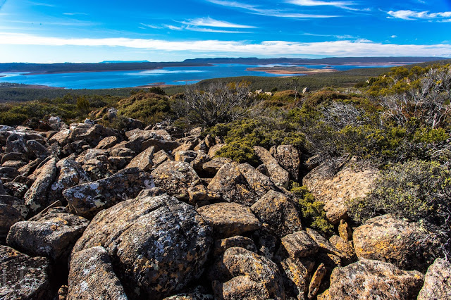
Unfortunately the wide-angle lens has flattened things out a bit. This shot is taken over 300ms above the lake.
In a long-gone era, when orderliness and reason were supreme values, mountains – with their jumbly chaos, their “hideous” height and irregular form – were so hated and feared that they were regarded as part of an angry God’s judgement on a sinful earth. Others argued that such undigested heaps of confusion could not come from a God of order and beauty, but from some other chaos. These jumble haters would have sure hated Rats Castle!

Preferring to invoke Norse mythology than these myopic understandings of God, when in a landscape such as that provided by this citadel for rats, I picture Thor in his fury, smashing stones like marbles in his wrath, tossing slabs of rock about the place in a wild mess.

From Rats Castle, near the summit

I thought of this image as Angela and I spent the best part of an hour negotiating the upper part of the ridgeline that leads to Rats Castle. We had adhered to the instructions in the book and forum, following an old fence, then climbing to the top, and finally following the ridge south to the summit. The junky rocks were exactly as those commentators on reason had depicted in their rather jaded, moralistic accounts. As we tiptoed through the field of discarded, ossified footballs, we had time for such musings. It took a little less than an hour to gain most of the height we’d needed, but another hour to traverse the mess, weaving in and out and around about, dextrously avoiding scoparia and other obstacles of a more jagged nature.

Summit view from Rats Castle
Three things saved the area, I decided, as we sat on top enjoying a leisurely … whatever the meal is called when it’s not lunchtime yet but you’re hungry, so eat your lunch ’cause you’re on top anyway:
(1) an amazingly blue lake (Great Lake) below, with patterns of mirror and ruffle on the shimmer (hardly the “blue scrofulous scum” as the mountain-hating Charles Cotton called a lake in 1681. It seems he was not keenly alive to the beauty of lakes either);
(2) tiny shapes we could recognise way in the distance: the Acropolis and Geryon to the west; Ben Lomond to the east, with Arthur and Saddleback rising out of localised clouds even further afield;
(3) the knowledge that we should make the most of this view, as the chances were highly unlikely that we would ever be back this way again. It wasn’t horrid or anything: it just lacked any “wow” factor that lifts the spirits, and life is short. On the smorgasbord of mountains, when I’m choosing second and third helpings, other treats will be more on my mind.
Sitting up there, chewing our cud, we could see no good reason at all for the oddly-shpaed route we had been advised to take, so opted for a direct descent and take whatever consequences came. The only one that did was a descent that was half an hour quicker than the inward journey. Angela, knowing what a rebel I am in every other way, asked what had ever possessed me to adhere to instructions on this occasion. I had no adequate answer for that unprecedented and unwarranted conservatism that had momentarily taken over.
Conservative ascent, following advice (top); creative descent, going for it (bottom / south).