Mayson 2016 Jul

Mt Mayson. Freycinet National Park. July 2016.

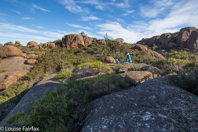
Angela stops for lunch after we have been to the summit of Mt Mayson.
What a messy, untidy mountain is Mt Mayson! Such a huge and daunting amount of giant-sized rubble with scrubby bush in between. I felt like a mouse in an elephant’s maze – assuming that such mice feel not only small and overwhelmed by the size of the blockades, but also frustrated. The scrub was only a little bit of a nuisance as the far bigger problems – posed by our inability to see what lay on the other side of the humungous boulders – kept us quite fully occupied.

After the summit we rewarded ourselves with lunch at this view of Wineglass
Progress was stunningly slow and my plait a total mess. Why do I mention my hair? Have I become very girly all of a sudden? No. It’s just that I’ve discovered that the state of disintegration of my plait after a walk is a very good indication of how horrid the scrub was. I emerged looking like a Very Wild Woman. As I was also wearing hideous orienteering pants that the Swiss team thought funny about twenty years ago (they are white with cow patterns on them. I keep wearing them in awful scrub to try to rip them so I can throw them out, but they will NOT be destroyed), I looked decidedly odd. It’s surprising that Angela was not too embarrassed to be seen with me in public. She is very tolerant. A man asked me about my outfit in Zeps in Campbeltown, and I told him I had been terrorising all the cows between there and Freycinet. He believed me and only wanted to know why. Fortunately my panini was ready at this stage, so I didn’t have to be creative and furnish him with a daft reason.
Looking towards Mt Amos – nice mountain with a track. What a difference a track makes!
As the crow flies, it is only about 500 ms between an internal saddle on Mayson and the summit. We had gone really well to this saddle, but it was this final 500 that was so slow it made the waddle of a fully pregnant pig look speedy. We took over an hour to cover that horizontal distance. At that stage you only have 160 ms left of vertical progress, so the steepness of the terrain is not to be blamed. The pattern of movement went something like: sigh, here’s another wall of rock in our nose. We suss out left and right and take a vote. Sometimes there’s a chute, so we also vote on whether to go up it or around. The danger, of course, is that you can haul yourself up, grabbing tiny bushes to save you from bone-breaking falls, yank yourself further up with a mighty heave, only to discover it’s a dead end. You can also go left or right and find yourself faced with a twenty metre drop to a rocky death below as a different kind of dead end.
In addition, there was the problem of runaway summits.
“Angela, this is it”, I call excitedly, eying up the shape of the land and the extreme height of the rock pile in front of me.
I crest the rise. Dashed. “Na. Forget it. There’s a higher bit over there.”

On we .. well, I was going to write “trudge”, but you can’t even trudge in territory like that. This made scampering up 2,000 ms of height gain in Europe seem such a wonderfully easy thing to do. You just put one foot in front of the other, dream and sing a bit and you’re there. Not so in this stuff!

 Behind where Angela is standing, near that precariously balanced rounded boulder on a boulder, we really could see the summit, so dumped our packs to make things easier. We decided, without yet seeing the summit view, that this spot was where we would return to to have our well-earned lunch. It was overlooking Wineglass Bay at just the aspect we fancied for a luncheon view. Sitting there munching, we decided that we were really quite over this mountain.

The way back down was way quicker, not just because it was down, but you can actually see far more going down, and also, of course, you can remember this and that chute, so you feel far more heartened, as you know it will work. I found all the trial and error to be psychologically exhausting. I would need a very huge bribe to tempt me to go back.

I can’t resist adding this to the blog, as Angela and I both got such a huge laugh out of it. Here is Stu Bowling sitting on top of the summit rock that no one else climbs. Stu and Martin Doran carted that ladder through all that jumble of boulders and heavy scrub for hours, so that they could touch the actual tippy top while the rest of us are content to touch some part of the stone that connects to the top. Thanks for sharing Stu :-), and for giving us a good laugh.

Proteus 2016 Jun

Mt Proteus

Dawn, summit day
Angela had three days clear (as did I); we decided Mt Proteus was a suitable mountain for this time of year and that time span. We knew Maureen needed Proteus on her way to completing all the Abels, so invited her too, and an expedition (albeit a little one) was born. Off we set excitedly on the Arm River track, heading west, and then the Overland Track heading north until our camping spot, just north of Pelion West (Pine Forest Moor). What lay in store for us? For the moment, light drizzle and not much of a view. Happy to have the day completed so we could get cozy in our tents, we filled up with water from the idyllic creek below, so lush you almost needed sunglasses to cut the vibrance, and retreated to our colourful homes among the pencil pines (Athrotaxis cypressoides – which grows between 700 and 1300 ms asl and has nothing to do with the pine family at all [or with pencils]. Homesick early settlers called anything evergreen “pine”). It was protected enough there under cover for us to have a relatively leisurely setting up process, and to spend a little time carefully choosing our piece of real estate for the night.

Frosted button grass, with Pelion East, Mt Ossa and Paddys Nut behind.

You should have heard me gasp with delight when I emerged into the open on the morning of the second (summit) day and saw the expanse of white depicted in the two photos above. I was thrilled with the freshness and delicacy of it all. This is the terrain we had to cross for many kilometres to meet our mountain. We found it tiring, as we had to lift our legs very high to get over that grass, sometimes unexpectedly falling in holes – often filled with water – hardly a welcome outcome on a morning such as this. We had had to don wet socks and boots at the start of the day, so accidental soakings were not quite as disastrous as might be imagined, but our toes were numb and frozen nonetheless. There were also two bands of pretty dense bauera bush, but they didn’t last very long, being narrow, and just as I was starting to wonder if it was going to be a fight the whole way, the vegetation became calf high, and we had easy access to the summit, now not far away.

Angela (L) and Maureen (R) at the summit cairn. Maureen looks very happy to only have ten Abels left to go.

It had taken 2 hours 38 to reach the summit. The book had said two; I had feared three, so this was a pretty good compromise. I had allowed for a possible ten-hour day when I asked the others if they minded starting at 7.30, so maybe we had won a little time. Off we set on our return journey. Once we knew which type of undergrowth in this area fared better (scoparia scattered amongst fern grass was faster than button grass, which we managed to mostly avoid on the rebound), we were able to cut a bit off our time, and after a tidy 2 hrs 7 mins we were back at our wonderful fairyland campsite, ready to relax with a cuppa before packing up our tents and moving on.

Angela photographing Ents at our campsite.

We squandered a little of our won time by being a tiny bit slow at packing up (I’d allowed an hour), and we were not ready to set out before 3.15. Maths said it would probably be dark by the time we reached Pelion Hut. Maths was unfortunately right, but we knew this was likely. I wanted a tiny break for a drink at Pelion Creek, and another for photography at Frog Flats. I also couldn’t resist a set of photos as we rounded a corner and saw Pelion West in the clear afternoon light. Cathedral mountain also looked a treat. These things take time …. Angela had predicted that we’d be able to do without head torches until 5.45 and she was right to the exact minute. By this stage it was becoming downright dangerous, as the boardwalk has steps that you couldn’t see in the dark, and falling would have been treacherous. Also, many of the boards lacked chicken-wire, and the ice of the morning had lingered on boards and leaves the whole day, turning the Overland Track into an elongated skating rink. The final twenty minutes were done by torchlight.

Paddys Nut and Mt Thetis as evening approaches from Frog Flats

I was hoping for another lovely frosted morning next day, but thick mist regaled us in our waking moments. At least it meant I didn’t hold the others up with too much photography. Off we set into the mist, hands burning with the cold, hoping that the climb to the high point on this track would warm us up.

The high point on the Arm River track, and the sun breaks through
We had only been going one and a half hours, but I was starving. Besides, some photos were in order!!! Don’t be put off by Angela’s shorts. It’s FREEZING.
Mt Pillinger bursting into the blue realm above.
A different tarn on the way home. I didn’t say I took NO photos – just not as many as I might have done.
It was all downhill from there, and thus ends another perfect little expedition. Mt Proteus is a wonderful mountain to have in my collection, and already the happy memories of our time there circle and recircle in my contended mind as I relive moments of beauty and wonder.

Brewery Knob 2016 May

Brewery Knob.

 Cortinarius levendulensis.

Angela in her new (unmarred) red anorak approaches the summit cairn

The weather map looked very colourful (= lots of rain forecast) for the day of our intended walk, and high winds were also predicted. However, Angela and I were more than keen to climb something – anything – despite the weather, so took a look at our options. The map ruled out anything south or west; east just didn’t call us; so we settled for north of central, and chose to re-climb Brewery Knob, which fell into a Goldilocks zone: not too high (i.e. windy), not too long a drive … not too anything really, and a nice little mountain sitting there at 1293 ms asl, protected a tiny bit by bigger friends close by. It got the foul-weather guernsey.

We came back the way we went out, and I’m glad we did. It gave us longer on this half-hour stretch of open moorland which we found to be fun.

Good choice. It was a perfect mountain for the conditions. First, we climbed through a stretch of rainforest that is always rich and glorious, but especially so at this time of year when bright orange pilelets of fagus leaves clump together, attractively caught in the interconnected mosaic of shining roots that make mini-swimmingpools along the track. The contrast between the burnt orange leaves and the lurid green moss makes for a mesmerising beauty. We both vowed to do some photography on the way back down, but I am a goal-centred person, so we stuck to the programme of climbing first, games afterwards (not that climbing isn’t the grandest game of all).

The path

As we changed gradient and forest type (after a tad under 30 mins’ walking), and took our first steps on the open Hounslow Heath, the expected wind hit us. On went coats, windproof gloves and more as we leant into the wind to continue. It was so loud – whistling in our ears and bashing our heads with its force – that conversation was impossible.

Similar to the first time I climbed this Knob with my husband, we struck a small band of thigh-high scoparia once on our compass bearing for the final part of the climb (the bearing revealing a slightly darker shape in the mist that we took to be our mount: I have yet to actually see it). We passed very cautiously through, both of us nervous about pin-pricking our beautiful new anoraks. Once on the plateau on top, vegetation was only about ankle high, and we were free to enjoy the huge sense of space made possible precisely because we could see nothing, but could feel infinity in the distance.

We were both delighted by our choice of mountain. It was perfect for that kind of weather, and, well, there’s a lot more to a mountain than the view it offers. The summit cairn is very attractive, and the feeling of being in a wild place, marvellous. It almost felt as if we were the only two living souls left on earth up there; it’s wonderful to escape the treadmill of modernity with its reduction of creativity and freedom, and its terror of risk and litigation that stifles every move and suffocates being kind and decent to one another.


Lord 2016 May

Mt Lord  7 May 2016

The first (and last) chunk of the walk is in rainforest.

I was surprised by my own reaction to Angela’s confirmation that she could still climb Mt Lord with me: I was excited to be going on another adventure together. What, you ask, is surprising about that? Well, I’d always thought I went bushwalking to see more beauty and to have a great workout in nature. I had never really thought of what I do as having an adventure per se. But there it was. The meaning of “adventure” is: an unusual, exciting or daring activity. I guess going bushwalking, in that it doesn’t happen every day, is unusual (but not very); it is exciting, as I am out in free nature, taking up the challenges of summiting another mountain. Daring? Well, I guess there’s always an element of slight risk. Whatever the definition, my mind saw it as being a fun adventure, and I just couldn’t wait.

We drove down after dinner on Friday, and pitched our tents close to a gurgling river that we could hear all night, and breakfasted next morning under stately gums. Our task for the day was short, and we had done most of the drive; there was no need to rush, so we were not ready to begin climbing until a bit after 9 o’clock.

There was a kind of a road sort of thing – maybe used by trucks to turn in – so we hitched a ride for the grand 15 metres it offered us, diving into the thick forest at a spot that perhaps looked more agreeable than the rest. Once in, and past the tangle of young saplings that grew near the source of light, things greatly improved, and we made our way up through the very steep yet pleasant rainforest, marvelling at the extreme size of the stumps that existed, rotting away, in that early part. I reckon it would take 30 Angela-Louises to occupy the surface area of some cuts.

Mostly the fungi were big, like these, although on the descent we saw some examples of smaller genera such as mycena, entoloma and cortinarius, in blue, red, green and purple.
The route was not easy, and we had to weave quite considerably to make progress. I was always a bit unsure of whether the direction I was pursuing would take us into a bosky cul-de-sac, so didn’t enjoy it quite as much as I might have. My concentration was on other things, but I still had a sense of the greenness and the clumps of large fungi.

After about an hour we emerged into the inevitable band of Bauera – but, oh joy, no Scoparia – and a jumble of washing-machine sized boulders to negotiate, with the odd buttressy cliff making an appearance.

Summit view
As we neared the wider summit area, the bushes thinned, but the going was still slow as the rocks were treacherously slippery, each one offering its own private, sloped rink to anyone who’d brought up skates. We hadn’t.

So slippery was it that I couldn’t even be bothered moving around to get a good shot from the summit. The “views” didn’t warrant the effort. It wasn’t quite 11 yet, but we had lunch nonetheless, as we’d carried it up there, and that’s what you do on top of a mountain. It was cold; the views were not great; neither of us is a mad-keen collector of peak bagging points, so, whatever the number attached to Lanes Peak across the way was, it failed to interest us – I also think we are both brewing some virus; we were not feeling fantastic – so we came straight down. One mountain was enough of an adventure for today. After half an hour on top, we began our descent, this time staying nearer to the creek for no particular reason; it’s just where we ended up and we saw no problem with that.

A different summit view.

The descent route was more beautiful that the outwards journey, but marginally slower in the endgame, as there were a lot of huge fallen trees, some with diameters over our heads that made climbing over their rich, mossy surfaces next to impossible. There was no room under them either, so a small expedition was required to follow each obstacle to one or other end to get around. I was glad we hadn’t climbed that close to the creek when outward bound, as that procedure might have been depressing. On the descent, knowing the end was nigh, we were not put off at all.

The route was short: only 1.6 kms in each direction, with 530ms climb in that short distance, so, as the contours above also indicate, very steep – but fun. The min/km rate of travel – roughly 1 km per hour!!! – gives an idea of the thickness of the bush and the number of obstacles. That said, the shortness meant that we finished quite early, could go straight to the Possum Shed for delicious food, and be back at home in the north before dinner time. Bring on the next one. (Cyan with a border is the downwards route)

Claude 2016 Apr

Mt Claude Apr 2016.

The view to the left before you leave the track to embark on the rocky climb
In terms of having intricate directions in the final stage of the climb, Mt Claude is one of the trickier mountains, so instead of my usual sort of entry, I am going to try to provide extra details in words and pictures to augment the already excellent instructions we had from www.bushwalk.com, the bushwalking forum. Despite their helpfulness, we did have two “detours” where we managed to stray, so hopefully the pictures and text below will help others who want to use this much safer route of climbing Mt Claude. I came across it last week and thought it looked fun. Angela agreed, so off we set.
Follow the main path (that begins on Olivers Road at the Lookout, and that, after you leave it, continues on the northern side of Claude, heading for Van Dyke) for about three kilometres, turning right and slightly down (ESE) where an arrow tells you to, rather than heading for the tower. We had a diversion to the tower due to not quite understanding the instructions. I’m not sad that I had the extra climb. It was quite interesting, but the excursion gave us a huge warning about how very slippery the conglomerate was today. I had already felt how greasy the rock was, but still got a horrid shock when I saw Angela’s foot come unexpectedly away from her in the descent back to the track, and she began gathering momentum as she fell. I watched in horror as her first attempt to grab something to arrest her fall failed. Luckily the second obstacle worked as I did not like the speed with which she was dropping. Of course, all this occupied maybe a single second, but it felt like an eternity as audience.
Back on the track we went to the south of the tower clump, and along to the flat saddle before the actual summit block. Below is a picture of where, in that saddle, you leave the path that continues more NE to drop down below the northern side of the impressive summit boulders. This little pad here goes to a slot that you climb up. There’s a cairn at the top, and the cairns were generally close enough to follow.
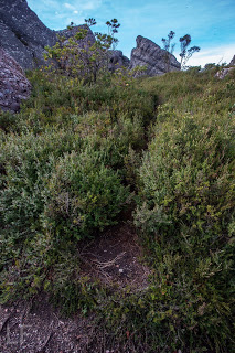
This is the pad you follow to exit the main track
Below you can see Angela climbing a slope, because I called her up. However once we were both up and consulted the notes from bushwalk.com she’d copied into her phone, we saw that we weren’t supposed to be lured by this steep, narrow path, so went back down. It was quite a nice little climb – not slippery like the rest of the day. However, if you get this view, you know you’re wrong.

Along and up we went, consulting the forum notes quite heavily now. They warned us not to proceed along the likely looking trail, pictured below, tempting as it is.

 Instead, the notes say, head for the sky, so that is what you can see Angela doing in this next image.
The notes then say that on the right, just a bit below where Angela is in the picture above, there is a turning to the right. Take it, and it leads to the entrance of the infamous cave. We were both a little apprehensive about how this rope section was going to be in such slippery conditions. Angela was worried about her knee that she’d hurt in the fall, and I wondered if my upper body could drag me up, if that was required, as I had had an operation the previous week and even running still hurts a bit, so my torso’s strength is compromised. Oh well, there was one way to find out.

When we looked into the cave, it was dark and foreboding. At first our eyes couldn’t make out anything at all, but gradually the rope that we’d been promised could be discerned. I could see that it had knots and loops in it, so that would help. The entrance was very narrow, and we didn’t have a clue what lay ahead, so both decided to leave our packs behind – a very sad decision, as that meant no camera, and no food on top. The entrance was so narrow that we wondered, not for the first time that day, how large people managed to use this route. I took the rope, put one foot in the loop, and set out, feeling in the dark for the next loop. It was too much trouble to get my foot in, and my upper body was coping, so I used my knees against the rocks – they had better traction than my boots – and hauled myself up. The series of knots gave good grabbing points, and my knees found indentations in the rock that held me. It worked, although that method hurt Angela’s injured joint. Once up, the summit was very close, and we happily touched it. Thick mist was now rolling in, rising to engulf us. We wanted to see to try to find our way down this slippery dip of a mountain, so set out pretty quickly. I was starting to feel nauseous with anxiety at choosing a route blind. I also didn’t know how it would be lowering ourselves on the rope when the rock offered absolutely no grip at all. It was a long way to fall. However, on the descent, I found I could decelerate by leaning my back into the wall above, creating a bit of pressure to combat gravity.
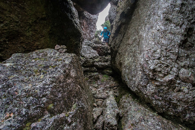
Hoorah, soon we were down and gathering packs again (Angela is buttoning hers up in the picture above). I wanted to get below the rock section before stopping for our snack so as to ensure visibility. It was with enormous relief that we sat with the view below, still rocky enough for beauty, but by this stage, all the potentially tricky route finding had been accomplished, and, although we were cold, we made time to eat. I needed to eat to relax more than to fill my stomach, I think.

Snack view, down low and out of danger of further falls
In front you see the pad that we followed to do the climb. Angela is standing at the pad-path intersection waiting for her friend who is now taking rather a lot of photos.

Goodbye pretty boulders. They really are wonderful if you’re not climbing up them when they’re moist.  Down we climbed, both looking forward to the food we were anticipating at the Raspberry Farm, which is fast becoming a traditional calorie replacement station.

I’m not happy with the clarity of this. I’ll add a map of just the last section in the morning. Hopefully that will give better detail.