Mt Elephant 5 Jan 2014
Head high in cutting grass
I was in a defiant mood today. Not only had the weather forecast cheated me of yesterday’s walk (quite rightly – the wind predictions were grim), but I used the day to line up my intended walks for the summer, only to be told that every single walk I wanted was full. Another summer of doing our own thing zu zweit. Boo.
So, that mood had me announce that we would ignore the unalluring weather forecast for today with its silly bright colours indicating rain all over the state and go climb a mountain anyway – the best antidote to sulking. We hadn’t done Mt Elephant yet, and it was in the east, which had the least dramatic BoM colours for rain, so we downed a hurried breakfast and got out on the road. This time I packed gear for blizzards, just in case.
Summit cairn perched on a rock
Driving along, the weather was magnificent, and we both revelled in the play of light on the mustard-coloured grasses waving in the light breeze. The outline of the Lomond massif to our left as we progressed along the valley was clear and cheering, even if the air was not as crisp and fresh as in winter. It was a beautiful trip.
We tried to eye up our elephant as we approached, but I decided you needed as much imagination for that one as is required to see a Boa who has swallowed a pachyderm rather than a hat at the start of Antoine de St Exupery’s The Little Prince.
Victory salute
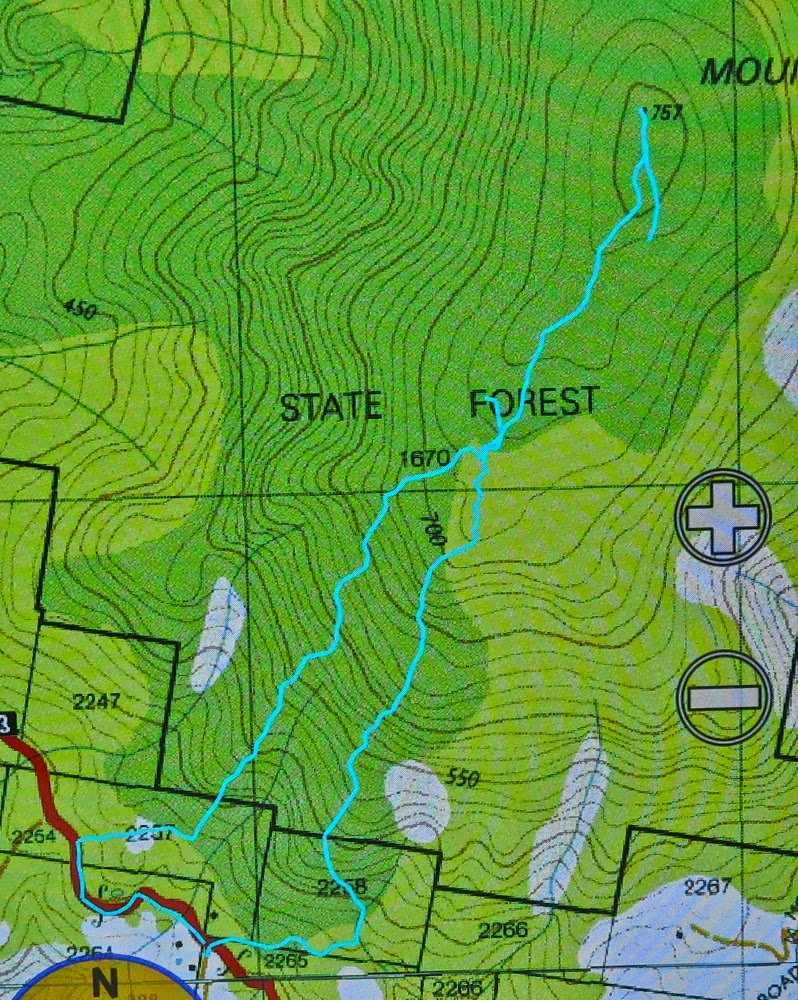
We looked for the spot described in my friend’s blog where the Pandani club had started, but were unsure as to its exact location, and we had no coordinates to help, so chose our own start, basically opposite the pancake parlour. Could come in handy at the end. A ridge came to meet the road there, so that suited me. We found a little track that got us maybe two hundred metres – away from the ridge, but what the heck – before we had to start earnestly uphill in a bush bashing spree. We both barked in two separate cough sonatas, our lungs objecting to the pollen we sent flying as we pushed through bushes that offered quite a bit of resistance. And then it got even thicker. No matter, we were on the ridge, so just had to be patient and, logically, if we kept putting one foot in front of the other, we must get there. Next came cutting grass that was over our heads high, and a forest of thick ferns.
A friendlier patch of smaller cutting grass
Visibility was not good, either in terms of vistas, or of the ground. I started getting a little unnerved about the fact that I never knew what I was treading on down there. I know what it is to be bitten by a tiger snake, and don’t wish to repeat the experience. This seemed like exactly the kind of country and undergrowth where i had my first encounter and I decided I was verging on tigriphobia (or serpentiphobia) today.
Na ja. Soon enough we were on the flat top of the mountain and I navigated us towards the dot on the map that marked the summit at the far end, still quite some way away. With visibility negligible, I was hoping I’d be accurate enough to see the tiny cairn that announced victory. 1 hr 27 mins after leaving our car, we touched it. Olay. The skies were getting decidedly darker and the wind was moaning. I was not looking forward to the return journey, so, in order to give some passing helicopter a chance to float by and offer us a lift – which we would accept – I decided we should eat, as I hate eating in the rain, and we might get hungry later, even though lunch time was still nearly two hours away.
We both felt that we made much better progress on the way down, firstly being further east than our ridge route up, and then swinging to be further west of our ascent. Admittedly, we did end up in some pretty stern dead ends of barricaded branches that brooked no arguments, but we also minimised the tall cutting grass, and we were going downhill. Our time of 1 hr 24 to get back to the car surprised us in that it barely bettered our time up. Going up, we were heading for a point feature, so I was careful about navigation; coming down we were heading for a line feature (road) so I decided to just go with whatever leads were easiest and walk along the road to the car at the end. This tactic brought us out in someone’s backyard about 300 metres west of the pass. The owner came onto his verandah to tell us we were trespassing, but was very nice in the presence of our humble apologies, so all was forgiven …. and now it was time for a pancake lunch. Hoorah.
It rained on the way home, and poured as we entered our driveway.
(Sorry the cyan line is broken. I was new to this toy and accidentally turned it off during the descent).